Three Pagodas Pass: Difference between revisions
KittenKlub (talk | contribs) →History: ce |
RodRabelo7 (talk | contribs) |
||
| (11 intermediate revisions by 9 users not shown) | |||
| Line 1: | Line 1: | ||
{{Short description|Mountain pass between Myanmar and Thailand}} |
|||
{{Infobox mountain pass |
{{Infobox mountain pass |
||
| name = Three Pagodas Pass |
| name = Three Pagodas Pass |
||
| Line 17: | Line 18: | ||
}} |
}} |
||
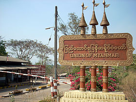
[[File:Three Pagodas.jpg|thumb|270px|The Three Pagodas]] |
[[File:Three Pagodas.jpg|thumb|270px|The Three Pagodas]] |
||
'''Three Pagodas Pass''' ([[Eastern Pwo language|Phlone]] {{my|ကၠံင်သိုင့်ဖၠုံးလါင့်ဆေါတ်ဖိုင်သာ့}}; {{lang-my|ဘုရားသုံးဆူ တောင်ကြားလမ်း}}, ''Paya Thon Zu Taung Za Lang'', {{IPA-my|pʰajá θóʊɰ̃ zù tàʊɰ̃ dʑá láɰ̃}}; {{lang-th|ด่านเจดีย์สามองค์}}, {{RTGS|''Dan Chedi Sam Ong''}}, {{IPA |
'''Three Pagodas Pass''' ([[Eastern Pwo language|Phlone]] {{my|ကၠံင်သိုင့်ဖၠုံးလါင့်ဆေါတ်ဖိုင်သာ့}}; {{lang-my|ဘုရားသုံးဆူ တောင်ကြားလမ်း}}, ''Paya Thon Zu Taung Za Lang'', {{IPA-my|pʰajá θóʊɰ̃ zù tàʊɰ̃ dʑá láɰ̃}}; {{lang-th|ด่านเจดีย์สามองค์}}, {{RTGS|''Dan Chedi Sam Ong''}}, {{IPA|th|dàːn tɕeːdiː sǎːm ʔoŋ}}) is a pass in the [[Tenasserim Hills]] on the border between [[Thailand]] and [[Myanmar]] (Burma), at an elevation of {{convert|282|m|ft}}. The pass links the town of [[Nong Lu#Sangkhla_Buri|Sangkhla Buri]] in the north of [[Kanchanaburi Province]], Thailand, to the town of [[Payathonsu]] in the south of [[Kayin State]], Myanmar. |
||
==Etymology == |
==Etymology == |
||
The pass is named after three small, crumbling [[stupa]]s or ''chedis'' which were probably built at the end of [[Ayutthaya Kingdom|Ayutthaya period]] as a symbol of peace. The pagodas are now on the Thai side of the border in the village of Phra Chedi Sam Ong.<ref name="dispute"/><ref name="fight2021"/> Parts of the border are still disputed.<ref name="dispute">[http://www.thailandhighlight.com/kanchanaburi-riverkwai/Three-Pagodas-Pass.html Thailand Highlight]</ref> These three chedis appear in the [[Seals of The Provinces of Thailand|provincial seal]] of [[Kanchanaburi Province]] in stylized form.<ref>[http://www.ratchakitcha.soc.go.th/DATA/PDF/2547/E/129/001.PDF Seals of The Provinces of Thailand]</ref> The pass gives its name to the [[Three Pagodas Fault]]. |
The pass is named after three small, crumbling [[stupa]]s or ''chedis'' which were probably built at the end of [[Ayutthaya Kingdom|Ayutthaya period]] as a symbol of peace. The pagodas are now on the Thai side of the border in the village of Phra Chedi Sam Ong.<ref name="dispute"/><ref name="fight2021"/> Parts of the border are still disputed.<ref name="dispute">[http://www.thailandhighlight.com/kanchanaburi-riverkwai/Three-Pagodas-Pass.html Thailand Highlight]</ref> These three chedis appear in the [[Seals of The Provinces of Thailand|provincial seal]] of [[Kanchanaburi Province]] in stylized form.<ref>[https://web.archive.org/web/20070930181854/http://www.ratchakitcha.soc.go.th/DATA/PDF/2547/E/129/001.PDF Seals of The Provinces of Thailand]</ref> The pass gives its name to the [[Three Pagodas Fault]]. |
||
== History == |
== History == |
||
The pass has been the main land route into western Thailand since ancient times. It is one of the few passes in the [[Tenasserim Hills]], and is believed be the point at which Buddhist teachings reached the country from India in the 3rd century.<ref name="asien">{{cite web|url=http://asienreisender.de/sangkhlaburi.html |title=Sangkhlaburi / Thailand|website=Asien Reisender|access-date=3 February 2022}}</ref> |
The pass has been the main land route into western Thailand since ancient times. It is one of the few passes in the [[Tenasserim Hills]], and is believed be the point at which Buddhist teachings reached the country from India in the 3rd century.<ref name="asien">{{cite web|url=http://asienreisender.de/sangkhlaburi.html |title=Sangkhlaburi / Thailand|website=Asien Reisender|access-date=3 February 2022}}</ref>{{Unreliable source?|date=July 2024}} |
||
During the [[Ayutthaya kingdom|Ayutthaya]] period in Thai history (14th–18th centuries), the pass was the main invasion route for the Burmese, but at times was also used against them by Siamese armies. The first Burmese invasion through the pass occurred in 1548 during the [[Burmese–Siamese War (1547–1549)]].<ref name=Damrong>Rajanubhab, D., 2001, ''Our Wars With the Burmese'', Bangkok: White Lotus Co. Ltd., {{ISBN|9747534584}}</ref>{{rp|15–16}} |
During the [[Ayutthaya kingdom|Ayutthaya]] period in Thai history (14th–18th centuries), the pass was the main invasion route for the Burmese, but at times was also used against them by Siamese armies. The first Burmese invasion through the pass occurred in 1548 during the [[Burmese–Siamese War (1547–1549)]].<ref name=Damrong>Rajanubhab, D., 2001, ''Our Wars With the Burmese'', Bangkok: White Lotus Co. Ltd., {{ISBN|9747534584}}</ref>{{rp|15–16}} |
||
During World War II, Japan built the infamous [[Death Railway]] (officially Taimen – Rensetsu Tetsudo) through the pass. There is a memorial to commemorate the thousands of British, Australian, Dutch and American prisoners of war, and Asian forced labourers who died |
During World War II, Japan built the infamous [[Death Railway]] (officially Taimen – Rensetsu Tetsudo) through the pass. There is a memorial to commemorate the thousands of British, Australian, Dutch and American prisoners of war, and Asian forced labourers who died during the construction of the railway.<ref name="asien"/><ref>{{cite web|url=http://www.plaques.satlink.com.au/misc/supporters.htm |title=Supporters of the plaques project |website=Australian Bronze Commerative Plaques|access-date=3 February 2022}}[sic]</ref> |
||
The region is home to several hill tribes, including [[Karen people|Karen]]s and [[Mon (ethnic group)|Mon]]s, who are unable or unwilling to obtain citizenship from either country. Separatist armies have repeatedly tried to |
The region is home to several hill tribes, including [[Karen people|Karen]]s and [[Mon (ethnic group)|Mon]]s, who are unable or unwilling to obtain citizenship from either country. Separatist armies have repeatedly tried to seize the pass from Myanmar, with the Mons in effective control until 1990, when Burmese troops regained it.<ref name="interpret">{{cite web|url=https://www.lowyinstitute.org/the-interpreter/incident-three-pagodas-pass |title=Incident at Three Pagodas Pass |author=Andrew Selth |website=The Interpreter at Lowy Institute|access-date=3 February 2022}}</ref> There is still occasional fighting in the area.<ref name="fight2021">{{cite news|url=https://www.bangkokpost.com/thailand/general/2105171/battle-erupts-in-myanmar-opposite-three-pagodas-pass |title=Battle erupts in Myanmar opposite Three Pagodas Pass |date=25 April 2021 |website=Bangkok Post|access-date=3 February 2022}}</ref> |
||
==Tourism== |
==Tourism== |
||
| Line 35: | Line 36: | ||
==Festivals== |
==Festivals== |
||
With the rambling strutting [[rooster]]s of the Buddhist temple of Wat Suwankhiri<ref>[http://www.lonelyplanet.com/thailand/phuket-province/sights/other/wat-suwankhiri Lonely Planet Thailand - Wat Suwankhiri ]</ref> on a [[Payathonsu]] cliff near by, during April, Three Pagodas Pass becomes a site of the [[Songkran (Thailand)|Songkran Festival]] with [[Cockfight (sacred)|cockfights]], [[ |
With the rambling strutting [[rooster]]s of the Buddhist temple of Wat Suwankhiri<ref>[http://www.lonelyplanet.com/thailand/phuket-province/sights/other/wat-suwankhiri Lonely Planet Thailand - Wat Suwankhiri ]</ref> on a [[Payathonsu]] cliff near by, during April, Three Pagodas Pass becomes a site of the [[Songkran (Thailand)|Songkran Festival]] with [[Cockfight (sacred)|cockfights]], [[Lethwei|Burmese kickboxing]] and various folk dancing.<ref>{{cite book|url=https://books.google.com/books?id=pmm6AAAAIAAJ&q=Songkran+Festival+cockfight|title=Lonely Planet Thailand|edition=8th|first=Joe|last=Cummings|author-link=Joe Cummings (travel writer)|year=1999|page=380}}</ref> |
||
==References== |
==References== |
||
Latest revision as of 00:27, 4 September 2024
| Three Pagodas Pass | |
|---|---|
 Myanmar–Thailand border checkpoint at Three Pagodas Pass. | |
| Elevation | 282 m (925 ft)[1] |
| Standort | Myanmar–Thailand border |
| Range | Tenasserim Hills |
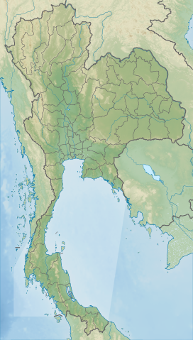
| Coordinates | 15°18′6″N 98°24′7″E / 15.30167°N 98.40194°E |

Three Pagodas Pass (Phlone ကၠံင်သိုင့်ဖၠုံးလါင့်ဆေါတ်ဖိုင်သာ့; Burmese: ဘုရားသုံးဆူ တောင်ကြားလမ်း, Paya Thon Zu Taung Za Lang, Burmese pronunciation: [pʰajá θóʊɰ̃ zù tàʊɰ̃ dʑá láɰ̃]; Thai: ด่านเจดีย์สามองค์, RTGS: Dan Chedi Sam Ong, Thai pronunciation: [dàːn tɕeːdiː sǎːm ʔoŋ]) is a pass in the Tenasserim Hills on the border between Thailand and Myanmar (Burma), at an elevation of 282 metres (925 ft). The pass links the town of Sangkhla Buri in the north of Kanchanaburi Province, Thailand, to the town of Payathonsu in the south of Kayin State, Myanmar.
Etymology
[edit]The pass is named after three small, crumbling stupas or chedis which were probably built at the end of Ayutthaya period as a symbol of peace. The pagodas are now on the Thai side of the border in the village of Phra Chedi Sam Ong.[2][3] Parts of the border are still disputed.[2] These three chedis appear in the provincial seal of Kanchanaburi Province in stylized form.[4] The pass gives its name to the Three Pagodas Fault.
History
[edit]The pass has been the main land route into western Thailand since ancient times. It is one of the few passes in the Tenasserim Hills, and is believed be the point at which Buddhist teachings reached the country from India in the 3rd century.[5][unreliable source?]
During the Ayutthaya period in Thai history (14th–18th centuries), the pass was the main invasion route for the Burmese, but at times was also used against them by Siamese armies. The first Burmese invasion through the pass occurred in 1548 during the Burmese–Siamese War (1547–1549).[6]: 15–16
During World War II, Japan built the infamous Death Railway (officially Taimen – Rensetsu Tetsudo) through the pass. There is a memorial to commemorate the thousands of British, Australian, Dutch and American prisoners of war, and Asian forced labourers who died during the construction of the railway.[5][7]
The region is home to several hill tribes, including Karens and Mons, who are unable or unwilling to obtain citizenship from either country. Separatist armies have repeatedly tried to seize the pass from Myanmar, with the Mons in effective control until 1990, when Burmese troops regained it.[8] There is still occasional fighting in the area.[3]
Tourism
[edit]Three Pagodas Pass is popular with tourists, who are allowed to obtain a one-day visa from the Thai side to visit Payathonsu. Attractions on the Burmese side include wooden furniture, jade carvings, and textiles. Thai tourists are allowed in as of 2011, while other tourists are not, due to its status as a temporary border checkpoint which only allows day trips between the two neighbouring countries.[9][10]
Festivals
[edit]With the rambling strutting roosters of the Buddhist temple of Wat Suwankhiri[11] on a Payathonsu cliff near by, during April, Three Pagodas Pass becomes a site of the Songkran Festival with cockfights, Burmese kickboxing and various folk dancing.[12]
References
[edit]- ^ Three Pagodas Pass, Encyclopædia Britannica
- ^ a b Thailand Highlight
- ^ a b "Battle erupts in Myanmar opposite Three Pagodas Pass". Bangkok Post. 25 April 2021. Retrieved 3 February 2022.
- ^ Seals of The Provinces of Thailand
- ^ a b "Sangkhlaburi / Thailand". Asien Reisender. Retrieved 3 February 2022.
- ^ Rajanubhab, D., 2001, Our Wars With the Burmese, Bangkok: White Lotus Co. Ltd., ISBN 9747534584
- ^ "Supporters of the plaques project". Australian Bronze Commerative Plaques. Retrieved 3 February 2022.[sic]
- ^ Andrew Selth. "Incident at Three Pagodas Pass". The Interpreter at Lowy Institute. Retrieved 3 February 2022.
- ^ List of Temporary and Permanent Border Checkpoint in Thailand, Foreign Affairs Division Office of the Permanent Secretary for Interior (Thai)
- ^ Senator Committee on Temporary and Permanent Boundary Checkpoints
- ^ Lonely Planet Thailand - Wat Suwankhiri
- ^ Cummings, Joe (1999). Lonely Planet Thailand (8th ed.). p. 380.
External links
[edit] Media related to Three Pagodas Pass at Wikimedia Commons
 Three Pagodas Pass travel guide from Wikivoyage
- Thailand By Train: Kanchanaburi and the River Kwai
- Thailand Travel Guide for Kanchanaburi

