
Krumbach, Bavaria: Difference between revisions
m robot Adding: da:Krumbach (Schwaben) |
page completed |
||
| Line 1: | Line 1: | ||
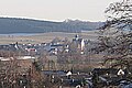
[[File:Krumbach vom Reschenberg aus.jpg|thumb| look at Krumbach (Swabia) from westen]] |
|||
{{Infobox German Location |
{{Infobox German Location |
||
|Name = Krumbach |
|Name = Krumbach |
||
| Line 20: | Line 21: | ||
}} |
}} |
||
'''Krumbach''' is a |
'''Krumbach (Swabia)''' is a town with about 12.500 residents in the district [[Günzburg (district)|Günzburg]] in the [[Bavaria|Bavarian]] administrative region [[Swabia (administrative region)|Swabia]], Germany. It is the second biggest town in the district. |
||
== Geography == |
|||
Krumbach ([[Elevation]] 512 m (1680 ft)) is situated in the [[natural regions of Germany|natural region]] [[Iller-Lech Plateau|Lower Iller-Lech Gravel Plateau]] (region between [[Danube]] and the Alps) in the valley of the [[Kammel]], a tributary of the [[Mindel]] river and so an indirect tributary of the [[Danube]] river. The landscape is of forests and areas in agricultural use (fields and grassland).<br> |
|||
The next bigger cities respectively towns are [[Ulm]], approximately 40 kilometres northwest of Krumbach, [[Augsburg]], 48 kilometres northeast of Krumbach and [[Memmingen]], about 40 km kilometres southwest of Krumbach. The distance to [[Munich]] is approximately 120 kilometres.<br> |
|||
== History == |
|||
In 1156 Krumbach was documentary mentioned the first time, in 1370 the village got the right to hold a market. From 1305 until 1805 Krumbach was part of the [[Burgau#History|Margraviate of Burgau]], which was part of the [[Habsburg|Habsburgian]] [[Further Austria]]. In the year 1805, by the [[Peace of Pressburg]] Krumbach became Bavarian. 90 years later Krumbach became a town. In the year 1902 the previously-independent municipality ''Hürben'', a neighbouring village of Krumbach, merged into Krumbach. Until the time of the the town had a high percentage of Jewish residents in comparison to the Bavarian average. |
|||
Until 1972 Krumbach was the district town of the administrative district “Krumbach (Swabia)“. |
|||
Bavarian regional reforms merged the previously-independent municipalities of Hohenraunau (1972/01/01), Billenhausen with Hirschfelden (1972/07/01), Edenhausen with the Krumbad (1973/01/01), Attenhausen (1977/01/01) and Niederraunau (1978/05/01) into Krumbach. |
|||
The Krumbad is a health resort approximately one kilometre east of Krumbach. It is the oldest health resort of Swabia. |
|||
== Coat of arms == |
|||
The colours of the town – red and white – as well as the arms – a silver-coloured waved thik line in red – remind one on the one hand of the longaffiliation to [[Further Austria]] on the other hand it is a canting arms – the crooked stream. In this context it is important to know, that the meander of the stream Kammel are in high gear. |
|||
== Attractions == |
|||
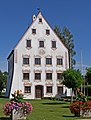
* market place and historic town hall |
|||
* church St Michael |
|||
* church St Ulrich in Hürben |
|||
* church ''Maria Hilf'' |
|||
* church ''Lindlkirche'' |
|||
* mills-chapel |
|||
* castle of Krumbach |
|||
* moated castle of Hürben |
|||
* ''Landauer building'' |
|||
* Middleswabian lokal heritage museum |
|||
* waxart museum MORSA |
|||
* Krumbad |
|||
* church of Niederraunau |
|||
* castle of Niederraunau |
|||
* ''Dossenberger parsonage'' Billenhausen |
|||
<gallery> |
|||
File:KRU-St-Michael.jpg|church St Michael |
|||
File:KRU-St-Micha02.jpg|church St Michael |
|||
File:KRU-St-Micha04.jpg|church St Michael |
|||
File:St Michael und Schloss vom Stadtpark aus.jpg|Church St Michael and Castle of Krumbach from the municipal park |
|||
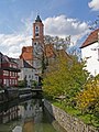
File:KRU-MuehlK01.jpg|mills-chapel at the stream Kammel |
|||
File:Krumbach centrum.JPG|market place and historic town hall |
|||
File:KRU-WaSchl01.jpg|moated castle of Hürben |
|||
File:Gesundbrunnenplatz Osterbrunnen.jpg|fontain at the ''Gesundbrunnenplatz'' in Krumbach – decorated in the Eastertide |
|||
File:KRU-KruBad03.jpg|Krumbad |
|||
File:Niederraunau.jpg|Niederraunau |
|||
File:Haseltal Kammel.JPG|Landscape near Krumbach |
|||
</gallery> |
|||
== Economy and Traffic and Public Institutions == |
|||
In Krumbach there are car suppliers, a paintfactory, plant construction factories, weaving mills, waxfactories and a wall-to-wall carpetingfactory. |
|||
Two [[Bundesstraße|Bundesstraßen]] pass Krumbach: the [[Bundesstraße 16]] (B 16) [[Günzburg]]-[[Mindelheim]] and the [[Bundesstraße 300]] (B 300) Memmingen-Augsburg. The distances to the [[Autobahn|Autobahnen]] [[Bundesautobahn 7|7]], [[Bundesautobahn 8|8]] and [[Bundesautobahn 96|96]] are each approximately 25 kilometres. Furthermore Krumbach has a railway station at the railway from Günzburg to Mindelheim ([[Mittelschwaben Railway]]), a loop line, which connects the main lines [[Bavarian Maximilian Railway]] (Munich-Augsburg-Ulm-[[Stuttgart]]) and [[Augsburg–Lindau railway]] (Munich-[[Buchloe]]-Memmingen-[[Lindau (Bodensee)]]).<br> |
|||
In Krumbach there are quite a view public institutions: police station, forestry commission office, planning department and several schools: secondary schools, grammar school and vocational schools; |
|||
== Miscellaneous == |
|||
In the valley of [[Günz]] – approximately six kilometres western of Krumbach there is the ''Oberrieder Weiher'', a flooded gravel pit and popular greenbelt recreation area. At the shores of this lake tere is a campingsite, too. |
|||
== References == |
|||
''This article incorporates text translated from the article [[:de:Krumbach (Schwaben)|Krumbach (Schwaben)]] from the [[German Wikipedia]], retrieved on 2 August 2009'' |
|||
== See also == |
|||
* [[Günzburg (district)]] |
|||
* [[:de:Liste der Gemeinden Ortschaften und Sehenswürdigkeiten im Landkreis Günzburg]] (page on the municipalities, places and places of interest in the district Günzburg) from the [[German Wikipedia]] |
|||
* [http://commons.wikimedia.org/wiki/Krumbach_(Schwaben) page on Krumbach (Schwaben) at Wikimedia Commons]''' |
|||
{{Günzburgdistrict-geo-stub}} |
|||
{{Cities and towns in Günzburg (district)}} |
{{Cities and towns in Günzburg (district)}} |
||
Revision as of 20:08, 2 August 2009

Krumbach | |
|---|---|
 Coat of arms | |
Location of Krumbach  | |
| Land | Deutschland |
| State | Bavaria |
| Admin. region | Schwaben |
| District | Günzburg |
| Regierung | |
| • Mayor | Hubert Fischer ("Junge Wähler-Offene Liste e.V.") |
| Area | |
| • Total | 44.75 km2 (17.28 sq mi) |
| Elevation | 512 m (1,680 ft) |
| Population (2023-12-31)[1] | |
| • Total | 13,940 |
| • Density | 310/km2 (810/sq mi) |
| Time zone | UTC+01:00 (CET) |
| • Summer (DST) | UTC+02:00 (CEST) |
| Postal codes | 86381 |
| Dialling codes | 08282 |
| Vehicle registration | GZ |
| Website | www.krumbach.de |
Krumbach (Swabia) is a town with about 12.500 residents in the district Günzburg in the Bavarian administrative region Swabia, Germany. It is the second biggest town in the district.
Geography
Krumbach (Elevation 512 m (1680 ft)) is situated in the natural region Lower Iller-Lech Gravel Plateau (region between Danube and the Alps) in the valley of the Kammel, a tributary of the Mindel river and so an indirect tributary of the Danube river. The landscape is of forests and areas in agricultural use (fields and grassland).
The next bigger cities respectively towns are Ulm, approximately 40 kilometres northwest of Krumbach, Augsburg, 48 kilometres northeast of Krumbach and Memmingen, about 40 km kilometres southwest of Krumbach. The distance to Munich is approximately 120 kilometres.
History
In 1156 Krumbach was documentary mentioned the first time, in 1370 the village got the right to hold a market. From 1305 until 1805 Krumbach was part of the Margraviate of Burgau, which was part of the Habsburgian Further Austria. In the year 1805, by the Peace of Pressburg Krumbach became Bavarian. 90 years later Krumbach became a town. In the year 1902 the previously-independent municipality Hürben, a neighbouring village of Krumbach, merged into Krumbach. Until the time of the the town had a high percentage of Jewish residents in comparison to the Bavarian average.
Until 1972 Krumbach was the district town of the administrative district “Krumbach (Swabia)“.
Bavarian regional reforms merged the previously-independent municipalities of Hohenraunau (1972/01/01), Billenhausen with Hirschfelden (1972/07/01), Edenhausen with the Krumbad (1973/01/01), Attenhausen (1977/01/01) and Niederraunau (1978/05/01) into Krumbach. The Krumbad is a health resort approximately one kilometre east of Krumbach. It is the oldest health resort of Swabia.
Coat of arms
The colours of the town – red and white – as well as the arms – a silver-coloured waved thik line in red – remind one on the one hand of the longaffiliation to Further Austria on the other hand it is a canting arms – the crooked stream. In this context it is important to know, that the meander of the stream Kammel are in high gear.
Attractions
- market place and historic town hall
- church St Michael
- church St Ulrich in Hürben
- church Maria Hilf
- church Lindlkirche
- mills-chapel
- castle of Krumbach
- moated castle of Hürben
- Landauer building
- Middleswabian lokal heritage museum
- waxart museum MORSA
- Krumbad
- church of Niederraunau
- castle of Niederraunau
- Dossenberger parsonage Billenhausen
-
 church St Michael
 -
 church St Michael
 -
 church St Michael
 -
 Church St Michael and Castle of Krumbach from the municipal park
 -
 mills-chapel at the stream Kammel
 -
 market place and historic town hall
 -
 moated castle of Hürben
 -
 fontain at the Gesundbrunnenplatz in Krumbach – decorated in the Eastertide
 -
 Krumbad
 -
 Niederraunau
 -
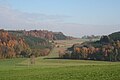 Landscape near Krumbach


Economy and Traffic and Public Institutions
In Krumbach there are car suppliers, a paintfactory, plant construction factories, weaving mills, waxfactories and a wall-to-wall carpetingfactory.
Two Bundesstraßen pass Krumbach: the Bundesstraße 16 (B 16) Günzburg-Mindelheim and the Bundesstraße 300 (B 300) Memmingen-Augsburg. The distances to the Autobahnen 7, 8 and 96 are each approximately 25 kilometres. Furthermore Krumbach has a railway station at the railway from Günzburg to Mindelheim (Mittelschwaben Railway), a loop line, which connects the main lines Bavarian Maximilian Railway (Munich-Augsburg-Ulm-Stuttgart) and Augsburg–Lindau railway (Munich-Buchloe-Memmingen-Lindau (Bodensee)).
In Krumbach there are quite a view public institutions: police station, forestry commission office, planning department and several schools: secondary schools, grammar school and vocational schools;
Miscellaneous
In the valley of Günz – approximately six kilometres western of Krumbach there is the Oberrieder Weiher, a flooded gravel pit and popular greenbelt recreation area. At the shores of this lake tere is a campingsite, too.
References
This article incorporates text translated from the article Krumbach (Schwaben) from the German Wikipedia, retrieved on 2 August 2009
See also
- Günzburg (district)
- de:Liste der Gemeinden Ortschaften und Sehenswürdigkeiten im Landkreis Günzburg (page on the municipalities, places and places of interest in the district Günzburg) from the German Wikipedia
- page on Krumbach (Schwaben) at Wikimedia Commons
- ^ Genesis Online-Datenbank des Bayerischen Landesamtes für Statistik Tabelle 12411-003r Fortschreibung des Bevölkerungsstandes: Gemeinden, Stichtag (Einwohnerzahlen auf Grundlage des Zensus 2011).