Rosava: Difference between revisions
Appearance
Content deleted Content added
←Created page with '{{Infobox river | river_name = Rosava River | image_name = Rosava.JPG | caption = Rosava near village Hamarnja | origin = North from village Rasavka,...' Tags: Mobile edit Mobile web edit |
m Moving Category:Rivers of Kiev Oblast to Category:Rivers of Kyiv Oblast per Wikipedia:Categories for discussion/Log/2020 October 6#Category:Kiev Oblast |
||
| (16 intermediate revisions by 9 users not shown) | |||
| Line 1: | Line 1: | ||
{{Infobox river |
{{Infobox river |
||
| |
| name = Rosava River |
||
| |
| image = Rosava.JPG |
||
| |
| image_caption = Rosava near village [[Hamarnja]] |
||
| |
| source1_location = North from village [[Rasavka]] |
||
| mouth = [[Ros |
| mouth = [[Ros (river)|Ros]] |
||
| mouth_coordinates = {{coord|49.63464|31.45755|type:river_region:UA|format=dms|display=it}} |
|||
| ⚫ | |||
| subdivision_type1 = Country |
|||
| length = 90 km |
|||
| ⚫ | |||
| watershed = 1,720 km² |
|||
| length = {{convert|90|km|abbr=on}} |
|||
| basin_size = {{convert|1,720|km2|abbr=on}} |
|||
| progression = [[Ros (river)|Ros]]→ {{RDnieper}} |
|||
}} |
}} |
||
'''Rosava''' ({{Lang-uk|Росава}}; {{Lang-pl|Rosawa}}) is a [[river]] in [[Ukraine]] located in the [[Dnieper Upland]], a left-bank tributary of the [[Ros |
The '''Rosava''' ({{Lang-uk|Росава}}; {{Lang-pl|Rosawa}}) is a [[river]] in [[Ukraine]] located in the [[Dnieper Upland]], a left-bank tributary of the [[Ros (river)|Ros]]. It is 90 km long and drains a basin area of 1,720 km². The river flows through [[Kyiv Oblast]] and [[Cherkasy Oblast]]. |
||
==Cities and towns on the Rosava== |
==Cities and towns on the Rosava== |
||
| Line 17: | Line 20: | ||
==References== |
==References== |
||
*http://www.encyclopediaofukraine.com/display.asp?linkpath=pages%5CR%5CO%5CRosavaRiver.htm |
*[http://www.encyclopediaofukraine.com/display.asp?linkpath=pages%5CR%5CO%5CRosavaRiver.htm Encyclopedia of Ukraine - Rosava River] |
||
[[Category:Dnieper Upland]] |
|||
[[Category:Rivers of Kyiv Oblast]] |
|||
[[Category:Rivers of Cherkasy Oblast]] |
|||
{{Ukraine-river-stub}} |
|||
Latest revision as of 00:40, 6 November 2020
| Rosava River | |
|---|---|
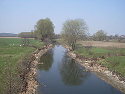
 Rosava near village Hamarnja | |
| Standort | |
| Land | Ukraine |
| Physical characteristics | |
| Source | |
| • location | North from village Rasavka |
| Mouth | Ros |
• coordinates | 49°38′05″N 31°27′27″E / 49.63464°N 31.45755°E |
| Length | 90 km (56 mi) |
| Basin size | 1,720 km2 (660 sq mi) |
| Basin features | |
| Progression | Ros→ Dnieper→ Dnieper–Bug estuary→ Black Sea |
The Rosava (Ukrainian: Росава; Polish: Rosawa) is a river in Ukraine located in the Dnieper Upland, a left-bank tributary of the Ros. It is 90 km long and drains a basin area of 1,720 km². The river flows through Kyiv Oblast and Cherkasy Oblast.
Cities and towns on the Rosava
[edit]References
[edit]
