Albán: Difference between revisions
Appearance
Content deleted Content added
m Bot: Migrating 1 interwiki links, now provided by Wikidata on d:q1524751 |
m Repair or remove missing or deleted templates |
||
| (20 intermediate revisions by 11 users not shown) | |||
| Line 1: | Line 1: | ||
{{other uses|Alban (disambiguation)}} |
{{other uses|Alban (disambiguation)}} |
||
{{Infobox |
{{Infobox settlement |
||
|name =Albán |
|name = San José de Albán |
||
|native_name |
|native_name = |
||
|nickname = |
|nickname = |
||
|motto = |
|motto = |
||
|settlement_type = [[Municipalities of Colombia|Municipality]] and town |
|settlement_type = [[Municipalities of Colombia|Municipality]] and town |
||
|image_skyline = |
|image_skyline = Alban.jpg |
||
|imagesize = |
|imagesize = |
||
|image_caption = |
|image_caption = View of Albán |
||
|image_flag = |
|image_flag = Flag of Albán-San José (Nariño).svg |
||
|image_seal = |
|image_seal = ESCUDO_MUNICIPIO_DE_ALBAN.jpg |
||
|image_map = Colombia - Nariño - |
|image_map = Colombia - Nariño - Albán.svg |
||
|mapsize = 250px |
|mapsize = 250px |
||
|map_caption = Location of the municipality and town of Albán in the Nariño Department of Colombia. |
|map_caption = Location of the municipality and town of Albán in the Nariño Department of Colombia. |
||
|pushpin_map = |
|pushpin_map = |
||
|pushpin_mapsize =300 |
|pushpin_mapsize = 300 |
||
|pushpin_map_caption |
|pushpin_map_caption = Location in Colombia |
||
|subdivision_type = Country |
|subdivision_type = Country |
||
|subdivision_name = {{flag|Colombia}} |
|subdivision_name = {{flag|Colombia}} |
||
|subdivision_type1 |
|subdivision_type1 = [[Departments of Colombia|Department]] |
||
|subdivision_name1 |
|subdivision_name1 = [[Nariño Department]] |
||
|subdivision_type2 = |
|subdivision_type2 = |
||
|subdivision_name2 = |
|subdivision_name2 = |
||
| Line 28: | Line 28: | ||
|established_date = |
|established_date = |
||
|area_magnitude = |
|area_magnitude = |
||
|area_total_km2 = |
|area_total_km2 = 43.47 |
||
|area_total_sq_mi = |
|area_total_sq_mi = |
||
|area_land_km2 = |
|area_land_km2 = |
||
| Line 39: | Line 39: | ||
|area_metro_km2 = |
|area_metro_km2 = |
||
|area_metro_sq_mi = |
|area_metro_sq_mi = |
||
|population_as_of = Census 2018<ref name="Censo">{{cite web|url=https://sitios.dane.gov.co/cnpv/#!/ |title=Censo Nacional de Población y Vivienda 2018|publisher=[[Departamento Administrativo Nacional de Estadística |DANE]]|lang=es |access-date=23 April 2020}}</ref> |
|||
|population_as_of = |
|||
|population_note = |
|population_note = |
||
|population_total = |
|population_total = 8197 |
||
|population_density_km2 = |
|population_density_km2 = auto |
||
|population_density_sq_mi = |
|population_density_sq_mi = |
||
|population_metro = |
|population_metro = |
||
|population_density_metro_km2 = |
|population_density_metro_km2 = |
||
|population_density_metro_sq_mi = |
|population_density_metro_sq_mi = |
||
|population_urban = |
|population_urban = |
||
|coordinates = {{coord|1|28|28|N|77|5|1|W|display=inline}} |
|||
|latd=|latm=|lats= |latNS=N |
|||
|longd=|longm=|longs= |longEW=W |
|||
|timezone = Colombia Standard Time |
|timezone = Colombia Standard Time |
||
|utc_offset = -5 |
|utc_offset = -5 |
||
| Line 60: | Line 59: | ||
}} |
}} |
||
'''Albán''' is a town and municipality in the [[Nariño Department]], [[Colombia]]. |
'''San José de Albán''' is a town and municipality in the [[Nariño Department]], [[Colombia]]. The town was established on 15 June 1573. As of 2018 it had a population of 8,197.<ref name="Censo"></ref> |
||
==Veredas== |
|||
| ⚫ | |||
The municipality contains the following ''veredas'': |
|||
{| style="background: #F5F5F5; padding:0em 1em 0em 1em;" |
|||
{{coord|1.47444|N|77.0836|W|source:kolossus-itwiki|display=title}} |
|||
| style="vertical-align:top" | |
|||
| width = "300" | |
|||
* 1. El Diviso |
|||
* 2. Betania |
|||
* 3. San Antonio de Guarangal |
|||
* 4. La Primavera |
|||
* 5. El Socorro |
|||
* 6. San Bosco |
|||
* 7. Tambo Alto |
|||
* 8. Tambo Bajo |
|||
* 9. Viña |
|||
* 10. El Cebadero |
|||
| valign="top" | |
|||
| width = "300" | |
|||
* 11. San Luis |
|||
* 12. Alto de Las Estrellas |
|||
* 13. Buena Vista Las Palmas |
|||
* 14. Casco Urbano |
|||
* 15. El Carmelo |
|||
* 16. Campobello |
|||
* 17. Fátima |
|||
* 18. El Salado |
|||
* 19. Chapiurco |
|||
|} |
|||
==References== |
|||
{{reflist}} |
|||
| ⚫ | |||
{{DEFAULTSORT:Alban}} |
|||
| ⚫ | |||
[[Category:Populated places in the Nariño Department]] |
|||
| ⚫ | |||
{{Nariño-geo-stub}} |
{{Nariño-geo-stub}} |
||
Latest revision as of 16:12, 23 December 2020
San José de Albán | |
|---|---|
Municipality and town | |
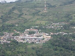
 View of Albán | |
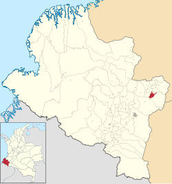
 Location of the municipality and town of Albán in the Nariño Department of Colombia. | |
| Coordinates: 1°28′28″N 77°5′1″W / 1.47444°N 77.08361°W | |
| Land | |
| Department | Nariño Department |
| Area | |
| • Total | 43.47 km2 (16.78 sq mi) |
| Population (Census 2018[1]) | |
| • Total | 8,197 |
| • Density | 190/km2 (490/sq mi) |
| Time zone | UTC-5 (Colombia Standard Time) |
San José de Albán is a town and municipality in the Nariño Department, Colombia. The town was established on 15 June 1573. As of 2018 it had a population of 8,197.[1]
Veredas
[edit]The municipality contains the following veredas:
|
|
References
[edit]- ^ a b "Censo Nacional de Población y Vivienda 2018" (in Spanish). DANE. Retrieved 23 April 2020.


