Alto Alegre, Roraima: Difference between revisions
Appearance
Content deleted Content added
m fmt coor |
RodRabelo7 (talk | contribs) m deprecated |
||
| (43 intermediate revisions by 30 users not shown) | |||
| Line 1: | Line 1: | ||
{{Infobox settlement |
|||
| ⚫ | |||
| official_name = Alto Alegre |
|||
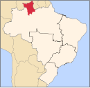
[[Image:Roraima Municip AltoAlegre.svg|right|thumb|250px|Location of Alto Alegre]] |
|||
| native_name = |
|||
'''Alto Alegre''' is a [[city]] in the [[Brazil]]ian [[Brazilian state|state]] of [[Roraima]]. The [[population]] in [[2004]] was 19,970, the population density is 0.78/km² and the area is 25,567 km². |
|||
| settlement_type = [[Municipalities of Brazil|Municipality]] |
|||
| image_shield = Brasao Alto Alegre RR.jpg |
|||
| image_flag = Bandeira Alto Alegre RR.jpg |
|||
| image_skyline = |
|||
| image_caption = |
|||
| image_map = Roraima Municip AltoAlegre.svg |
|||
| map_caption = Location in Roraima state |
|||
| pushpin_map = Brazil |
|||
| pushpin_map_caption = Location in Brazil |
|||
| ⚫ | |||
| subdivision_type = [[List of sovereign states|Country]] |
|||
| subdivision_name = Brazil |
|||
| subdivision_type1 = [[Regions of Brazil|Region]] |
|||
| subdivision_name1 = [[North Region, Brazil|North]] |
|||
| subdivision_type2 = [[States of Brazil|State]] |
|||
| subdivision_name2 = [[Roraima]] |
|||
| subdivision_type3 = [[Mesoregions of Brazil|Mesoregion]] |
|||
| subdivision_name3 = |
|||
| subdivision_type4 = [[Microregion (Brazil)|Microregion]] |
|||
| subdivision_name4 = |
|||
| subdivision_type5 = [[Metropolitan area#Brazil|Metrop. region]] |
|||
| subdivision_name5 = |
|||
| established_title = |
|||
| established_date = |
|||
| leader_party = [[Social Democratic Party (Brazil, 2011)|PSD]] |
|||
| leader_title = [[Mayor]] |
|||
| leader_name = Pedro Henrique Machado |
|||
| elevation_m = |
|||
| area_footnotes = |
|||
| area_total_km2 = 25,567 |
|||
| area_metro_km2 = |
|||
| population_footnotes = |
|||
| population_total = 15,380 |
|||
| population_as_of = 2020 <ref>[https://cidades.ibge.gov.br/brasil/ro/porto-velho/panorama IBGE 2020]</ref> |
|||
| population_metro = |
|||
| population_density_km2 = auto |
|||
| population_demonym = |
|||
| blank_name_sec1 = [[Human Development Index|HDI]] |
|||
| blank_info_sec1 = |
|||
| timezone1 = [[Time in Brazil|AMT]] |
|||
| utc_offset1 = −4 |
|||
| timezone1_DST = |
|||
| utc_offset1_DST = |
|||
| postal_code_type = [[List of postal codes in Brazil|Postal code]] |
|||
| postal_code = |
|||
| area_code_type = [[List of dialling codes in Brazil|Area code]] |
|||
| area_code = |
|||
| website = [http://altoalegre.rr.gov.br/ altoalegre.rr.gov.br] |
|||
}} |
|||
'''Alto Alegre''' ({{IPA|pt|ˈawtu aˈlɛɡɾi}}) is a [[city]] in the [[Brazil]]ian [[Brazilian state|state]] of [[Roraima]]. The [[population]] in 2020 was 15,380, and the area is 25,567 km².<ref>{{Cite web|url=http://cod.ibge.gov.br/J6E|title=IBGE {{!}} Cidades {{!}} Roraima {{!}} Alto Alegre|website=cidades.ibge.gov.br|access-date=2016-06-15}}</ref> |
|||
Its limits are [[Amajari]] to the north, [[Boa Vista, Roraima|Boa Vista]] in the east, [[Mucajaí]] and [[Iracema, Roraima|Iracema]] in the south, and [[Venezuela]] in the west. |
Its limits are [[Amajari]] to the north, [[Boa Vista, Roraima|Boa Vista]] in the east, [[Mucajaí]] and [[Iracema, Roraima|Iracema]] in the south, and [[Venezuela]] in the west. |
||
Alto Alegre was founded by Pedro Costa, a gold miner. In 1982, it became an independent municipality.<ref>{{cite web|url=https://cidades.ibge.gov.br/brasil/rr/alto-alegre/historico |title=Alto Alegre |website=[[IBGE]]|access-date=15 April 2021|language=pt}}</ref> It can be accessed from the RR-205 highway from [[Boa Vista, Roraima|Boa Vista]].<ref>{{cite web|url=http://altoalegre.rr.gov.br/3/pagina |title=sobre Alto Alegre|website=Municipality of Alto Alegre|access-date=15 April 2021|language=pt}}</ref> |
|||
The municipality contains part of the [[Roraima National Forest]].<ref>{{citation|language=Portuguese |title=Características da UC|publisher=ICMBio |url=http://flonarr.blogspot.ca/p/caracteristicas-da-uc.html|accessdate=2016-05-19}}</ref> |
|||
==References== |
|||
{{reflist}} |
|||
==External links== |
|||
* [http://altoalegre.rr.gov.br/ Official website] (in Portuguese) |
|||
* {{commons category-inline}} |
|||
{{Geographic Location |
|||
|title = '''Destinations from Alto Alegre''' |
|||
|Northwest = |
|||
|North = [[Amajari]] |
|||
|West = [[Alto Orinoco Municipality|Alto Orinoco]] ([[Venezuela]]) |
|||
|Center = Alto Alegre |
|||
|East = [[Boa Vista, Roraima|Boa Vista]] |
|||
|Southwest = |
|||
|South = [[Iracema, Roraima|Iracema]]<br>[[Mucajaí]] |
|||
|Southeast = [[Mucajaí]] |
|||
}} |
|||
{{Municipalities of Roraima}} |
|||
[[Category: |
[[Category:Municipalities in Roraima]] |
||
| ⚫ | |||
| ⚫ | |||
[[fr:Alto Alegre (Roraima)]] |
|||
[[it:Alto Alegre (Roraima)]] |
|||
[[no:Alto Alegre (Roraima)]] |
|||
[[pt:Alto Alegre (Roraima)]] |
|||
[[ru:Алту-Алегри (Рорайма)]] |
|||
[[vo:Alto Alegre (Roraima)]] |
|||
Latest revision as of 07:10, 9 August 2024
Alto Alegre | |
|---|---|
 Location in Roraima state | |
| Coordinates: 2°59′16″N 61°18′16″W / 2.98778°N 61.30444°W | |
| Land | Brasilien |
| Region | North |
| State | Roraima |
| Regierung | |
| • Mayor | Pedro Henrique Machado (PSD) |
| Area | |
| • Total | 25,567 km2 (9,871 sq mi) |
| Population (2020 [1]) | |
| • Total | 15,380 |
| • Density | 0.60/km2 (1.6/sq mi) |
| Time zone | UTC−4 (AMT) |
| Website | altoalegre.rr.gov.br |
Alto Alegre (Portuguese pronunciation: [ˈawtu aˈlɛɡɾi]) is a city in the Brazilian state of Roraima. The population in 2020 was 15,380, and the area is 25,567 km².[2] Its limits are Amajari to the north, Boa Vista in the east, Mucajaí and Iracema in the south, and Venezuela in the west.
Alto Alegre was founded by Pedro Costa, a gold miner. In 1982, it became an independent municipality.[3] It can be accessed from the RR-205 highway from Boa Vista.[4]
The municipality contains part of the Roraima National Forest.[5]
References
[edit]- ^ IBGE 2020
- ^ "IBGE | Cidades | Roraima | Alto Alegre". cidades.ibge.gov.br. Retrieved 2016-06-15.
- ^ "Alto Alegre". IBGE (in Portuguese). Retrieved 15 April 2021.
- ^ "sobre Alto Alegre". Municipality of Alto Alegre (in Portuguese). Retrieved 15 April 2021.
- ^ Características da UC (in Portuguese), ICMBio, retrieved 2016-05-19
External links
[edit]- Official website (in Portuguese)
 Media related to Alto Alegre (Roraima) at Wikimedia Commons


