Villanueva de la Vera: Difference between revisions
Appearance
Content deleted Content added
Nick Number (talk | contribs) repaired link(s) to disambiguation pages (you can help) - Cáceres; dmy dates |
Minor fix Tags: Mobile edit Mobile web edit Advanced mobile edit |
||
| Line 5: | Line 5: | ||
| nickname = |
| nickname = |
||
| image_flag = Bandera de Villanueva de la Vera.svg |
| image_flag = Bandera de Villanueva de la Vera.svg |
||
| |
| image_shield = Escudo de Villanueva de la Vera.svg |
||
| image_map = Mapa de Villanueva de la Vera (Cáceres).svg |
| image_map = Mapa de Villanueva de la Vera (Cáceres).svg |
||
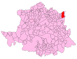
| map_caption = Map of Villanueva de la Vera, Cáceres |
| map_caption = Map of Villanueva de la Vera, Cáceres |
||
Latest revision as of 17:42, 15 March 2021
Villanueva de la Vera, Spain | |
|---|---|
municipality | |
 Town of Villanueva de la Vera in the province of Cáceres | |
 Map of Villanueva de la Vera, Cáceres | |
| Land | Spanien |
| Autonomous community | Extremadura |
| Province | Cáceres |
| Municipality | Villanueva de la Vera |
| Area | |
| • Total | 132 km2 (51 sq mi) |
| Elevation | 498 m (1,634 ft) |
| Population (2018)[1] | |
| • Total | 2,046 |
| • Density | 16/km2 (40/sq mi) |
| Time zone | UTC+1 (CET) |
| • Summer (DST) | UTC+2 (CEST) |
Villanueva de la Vera is a municipality located in the province of Cáceres, Extremadura, Spain. According to the 2005 census (INE), the municipality has a population of 2,163.
References
[edit]- ^ Municipal Register of Spain 2018. National Statistics Institute.


