
Whairepo Lagoon: Difference between revisions
Added meaning of Whairepo, mentioned fountain. |
m reverted change to gallery |
||
| Line 8: | Line 8: | ||
==Gallery== |
==Gallery== |
||
<gallery> |
|||
<gallery mode="packed" heights="150" caption="Whairepo Lagoon and surrounds">> |
|||
Pedal Boat Lake (27095178232).jpg|Pedal boats on the lagoon |
Pedal Boat Lake (27095178232).jpg|Pedal boats on the lagoon |
||
A performance at the waterfront, Wellington (screenshot).png|A performance at the waterfront |
A performance at the waterfront, Wellington (screenshot).png|A performance at the waterfront |
||
Revision as of 04:41, 29 September 2021

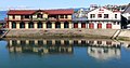
Whairepo Lagoon is an open public area at the centre of Wellington, New Zealand. It is a small man-made lagoon filled with sea water and connected to Wellington Harbour through a narrow channel. It is surrounded by The Boat Shed, City-to-Sea bridge, and the Wellington Rowing, Star Boating Club, and Te Raukura buildings. Tanya Ashken's Albatross fountain sits on the north side of the lagoon between it and Frank Kitts Park.
On 17 December 2015 the lagoon was officially named Whairepo Lagoon, as it previously had no official name. The lagoon was previously referred to as Frank Kitts Lagoon, Frank Kitts Park Lagoon, The Lagoon and Aotea Lagoon. 'Whairepo' is the Maori name for the Eagle ray which can sometimes be seen in the lagoon.[1]
Gallery
-
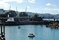 Pedal boats on the lagoon
 -
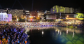 A performance at the waterfront
 -
 City to Sea Bridge
 -
 A view of Wellington's civic and commercial centre from the seaward side of the lagoon
 -
 The Boatshed
 -
 View of Te Papa and surrounding buildings from the lagoon
.jpg)
.png)
.jpg)

.JPG)

References
- ^ "Wellington Lagoon Gets a New Name". 17 December 2015.
{{cite web}}: CS1 maint: url-status (link)
External links
41°17′19″S 174°46′45″E / 41.288652°S 174.779037°E
This Wellington Region-related geography article is a stub. You can help Wikipedia by expanding it. |