Bonlieu: Difference between revisions
Appearance
Content deleted Content added
BigBullfrog (talk | contribs) No edit summary |
mNo edit summary |
||
| Line 20: | Line 20: | ||
}} |
}} |
||
'''Bonlieu''' ({{IPA-fr|bɔ̃ljø}}) is a [[Communes of France|commune]] in the [[Jura (department)|Jura]] [[Departments of France|department]] in [[Bourgogne-Franche-Comté]] in eastern [[France]]. |
'''Bonlieu''' ({{IPA-fr|bɔ̃ljø}}) is a [[Communes of France|commune]] in the [[Jura (department)|Jura]] [[Departments of France|department]] in [[Bourgogne-Franche-Comté]] in eastern [[France]].<ref>[https://www.insee.fr/fr/metadonnees/cog/commune/COM39063-bonlieu INSEE commune file]</ref> |
||
==Population== |
==Population== |
||
| Line 68: | Line 68: | ||
==References== |
==References== |
||
* [http://www.insee.fr/fr/themes/comparateur.asp?codgeo=com-39063 INSEE statistics] |
|||
{{Reflist}} |
{{Reflist}} |
||
Revision as of 09:27, 16 March 2022
Bonlieu | |
|---|---|
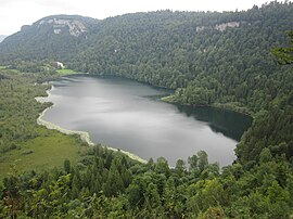
 Lac de Bonlieu | |
| Coordinates: 46°36′06″N 5°51′15″E / 46.6017°N 5.8542°E | |
| Land | Frankreich |
| Region | Bourgogne-Franche-Comté |
| Department | Jura |
| Arrondissement | Lons-le-Saunier |
| Canton | Saint-Laurent-en-Grandvaux |
| Regierung | |
| • Mayor (2020–2026) | Hervé Revol[1] |
| Area 1 | 13.05 km2 (5.04 sq mi) |
| Population (2021)[2] | 234 |
| • Density | 18/km2 (46/sq mi) |
| Time zone | UTC+01:00 (CET) |
| • Summer (DST) | UTC+02:00 (CEST) |
| INSEE/Postal code | 39063 /39130 |
| Elevation | 620–1,023 m (2,034–3,356 ft) |
| 1 French Land Register data, which excludes lakes, ponds, glaciers > 1 km2 (0.386 sq mi or 247 acres) and river estuaries. | |
Bonlieu (French pronunciation: [bɔ̃ljø]) is a commune in the Jura department in Bourgogne-Franche-Comté in eastern Frankreich.[3]
Population
|
|
See also
References
- ^ "Répertoire national des élus: les maires". data.gouv.fr, Plateforme ouverte des données publiques françaises (in French). 2 December 2020.
- ^ "Populations légales 2021" (in French). The National Institute of Statistics and Economic Studies. 28 December 2023.
- ^ INSEE commune file
Wikimedia Commons has media related to Bonlieu.


