Gyál: Difference between revisions
Appearance
Content deleted Content added
→Twin towns – sister cities: unsourced content removed |
→top: Doğukeppanochomolungmahokutotenkachōjo made edit on; Removed/Fixed (unnecessary) & undefined section(s) of the Template:Infobox settlement with unknown parameters &/or (extensive format fix) per WP:INFOBOXNAME, (int. per date - april 2022) |
||
| Line 13: | Line 13: | ||
|pushpin_map_caption =Location of Gyál |
|pushpin_map_caption =Location of Gyál |
||
|pushpin_mapsize = |
|pushpin_mapsize = |
||
|map=[[Image:PestMegye.png|center|thumb|275px|Location of Pest county in Hungary]] |
|||
|subdivision_type1=[[Counties of Hungary|County]] |
|subdivision_type1=[[Counties of Hungary|County]] |
||
|subdivision_name1=[[Pest County|Pest]] |
|subdivision_name1=[[Pest County|Pest]] |
||
Revision as of 15:12, 8 April 2022
This article needs additional citations for verification. (March 2009) |
Gyál | |
|---|---|
| Coordinates: 47°23′10″N 19°13′09″E / 47.38607°N 19.21922°E | |
| Land | |
| County | Pest |
| District | Gyál |
| Area | |
| • Total | 24.93 km2 (9.63 sq mi) |
| Population (2007) | |
| • Total | 22,552 |
| • Density | 873.12/km2 (2,261.4/sq mi) |
| Time zone | UTC+1 (CET) |
| • Summer (DST) | UTC+2 (CEST) |
| Postal code | 2360 |
| Area code | (+36) 29 |
| Website | www |
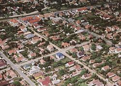
Gyál [ɟaːl] is a town in Pest county, Budapest metropolitan area, Hungary. It has a population of 22,552. In 1949 it had only 4,104 inhabitants. During the socialist era, Gyál become a garden suburb of Budapest.
Twin towns – sister cities
 Chibed, Romania
References
- ^ "Testvértelepülés" (in Hungarian). Gyál. Retrieved 2021-04-07.
External links
Wikimedia Commons has media related to Gyál.
- Official website in Hungarian
- Street map (in Hungarian)


