Thénia District: Difference between revisions
Appearance
Content deleted Content added
→Notable people: Adding Mohamed Rahmoune |
Adding Category:Thénia |
||
| Line 283: | Line 283: | ||
{{DEFAULTSORT:Thenia District}} |
{{DEFAULTSORT:Thenia District}} |
||
[[Category:Districts of Boumerdès Province]] |
[[Category:Districts of Boumerdès Province]] |
||
[[Category:Thénia]] |
|||
{{Boumerdès-geo-stub}} |
{{Boumerdès-geo-stub}} |
||
Revision as of 13:00, 17 April 2022
Thénia District
دائرة الثنية | |
|---|---|
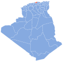
 Map of Algeria highlighting Boumerdès Province | |
| Country | |
| Province | Boumerdès |
| District seat | Thénia |
| Population (1998) | |
| • Total | 52,448 |
| Time zone | UTC+01 (CET) |
| Municipalities | 4 |
Thénia is a district in Boumerdès Province, Algeria. It was named after its capital, Thénia which, under French rule, was called Ménerville.
Municipalities
The district is further divided into 4 municipalities:
Villages
The villages of Thénia District are:
- B
- C
- F
- L
- T
- Z
Zawiya
History
French conquest
- Battle of Thénia (1837), a battle during the French conquest of Algeria.
- First Battle of the Issers (1837), a battle during the French conquest of Algeria.
- Battle of Thénia (1846), a battle during the French conquest of Algeria.
- Battle of Thénia (1871), a battle during the Mokrani Revolt of Algeria.
Algerian Revolution
Salafist terrorism
- 2007 Souk El Had bombing (13 February 2007)
- 2008 Thénia bombing (29 January 2008)
- 2008 Beni Amrane bombings (9 June 2008)
- 2010 Ammal bombing (11 June 2010)
- 2012 Thénia bombing (11 January 2012)
Rivers

This district is crossed by several rivers:
Dams
This district has two dams:
Football clubs
| Club | Division | Level | Location | Logo |
|---|---|---|---|---|
| CMB Thénia | Ligue Régional II | 5 | Thénia | |
| O Souk El Had | Ligue de Football de la Wilaya | 3 | Souk El Had | 
|
| CS Ammal | Ligue de Football de la Wilaya | 5 | Ammal | 
|
| IRB Souk El Had | Ligue de Football de la Wilaya | 3 | Souk El Had | 
|
| US Beni Amrane | Ligue de Football de la Wilaya | 3 | Beni Amrane | 
|
Notable people
- Abdenour Boushaki, Algerian politician.
- Abderrahmane Boushaki, Algerian leader.
- Ahmed Bourenane, Algerian politician.
- Ahmed Hadhoum, Algerian politician.
- Ali Boushaki, Algerian theologian.
- Amine ibn El Boushaki, Algerian judoka.
- Boualem Boukacem, Algerian artist.
- Brahim Boushaki, Algerian theologian.
- Dahmane Deriche, Algerian politician.
- Dahmane Deriche, Algerian artist.
- Farid Ishak Boushaki, Algerian academician.
- Feriel Boushaki, Algerian artist.
- Firmus, Berber leader.
- Fodil Mezali, an Algerian journalist.
- Gildo, Berber leader.
- Hocine Soltani, Algerian boxer.
- Lyès Deriche, Algerian leader.
- Maamar Bettayeb, Algerian academician.
- Mascezel, Berber leader.
- Mohamed Aïchaoui, Algerian journalist.
- Mohamed Allalou, Algerian boxer.
- Mohamed Arkab, Algerian politician.
- Mohamed Boumerdassi, Algerian artist.
- Mohamed Bourenane, Algerian politician.
- Mohamed Deriche, Algerian politician.
- Mohamed Deriche, Algerian academician.
- Mohamed Hassaïne, Algerian journalist.
- Mohamed Mechkarini, Algerian militant.
- Mohamed Missouri, Algerian boxer.
- Mohamed Nassim Boushaki, Algerian academician.
- Mohamed Rahmoune, Algerian politician.
- Mohamed Seghir Boushaki, Algerian politician.
- Mustapha Ishak Boushaki, Algerian academician.
- Noureddine Melikechi, Algerian physicist.
- Nubel, Berber leader.
- Rachid Deriche, Algerian academician.
- Salah Bouchatal, Algerian politician.
- Salem Anou, Algerian politician.
- Shahnez Boushaki, Algerian basketball player.
- Tarek Boushaki, Algerian academician.
- Yahia Boushaki (Shahid), Algerian politician.

