Kizlyarsky otdel: Difference between revisions
No edit summary |
No edit summary |
||
| Line 1: | Line 1: | ||
{{distinguish|Kizlyarsky District}} |
|||
{{Infobox settlement |
{{Infobox settlement |
||
| name = Kizlyarsky otdel |
| name = Kizlyarsky otdel |
||
Revision as of 01:07, 31 December 2022
Kizlyarsky otdel
Килярскій отдѣлъ | |
|---|---|
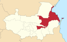
 Location in the Terek Oblast | |
| Land | Russian Empire |
| Viceroyalty | Caucasus |
| Oblast | Terek |
| Established | 1785 |
| Abolished | 1924 |
| Capital | Kizlyar |
| Area | |
| • Total | 5,756.56 km2 (2,222.62 sq mi) |
| Population (1916) | |
| • Total | 136,749 |
| • Density | 24/km2 (62/sq mi) |
| • Urban | 11.81% |
| • Rural | 88.19% |
The Kizlyarsky otdel[a] was a Cossack district (otdel) of the Terek Oblast of the Caucasus Viceroyalty of the Russian Empire. The area of the Kizlyarsky otdel makes up part of the North Caucasian Federal District of Russia. The Kizlyarsky otdel was eponymously named for its administrative center, Kizlyar.[1]
Administrative divisions
The subcounties (uchastoks) of the Kizlyarsky otdel were as follows:[2]
| Uchastok | Russian name | 1912 population |
|---|---|---|
| 1st | 1-й участокъ | 15,007 |
| 2nd | 2-й участокъ | 28,325 |
| 3rd | 3-й участокъ | 19,194 |
| 4th | 4-й участокъ | 35,290 |
Demographics
Russian Empire census (1897)
According to the Russian Empire census of 1897, the Kizlyarsky otdel had a population of 102,395, including 53,605 men and 48,790 women. The majority of the population indicated Russian to be their mother tongue, with a significant Nogai speaking minority.[3]
| Sprache | Native speakers | % |
|---|---|---|
| Russian | 53,785 | 52.53 |
| Nogai | 31,650 | 30.91 |
| Armenian | 4,681 | 4.57 |
| Ukrainian | 4,139 | 4.04 |
| Kalmyk | 1,417 | 1.38 |
| Georgian | 1,030 | 1.01 |
| Turkmen | 1,029 | 1.00 |
| Kumyk | 988 | 0.96 |
| Tatar[b] | 955 | 0.93 |
| Chechen | 864 | 0.84 |
| Dargin | 571 | 0.56 |
| Persian | 233 | 0.23 |
| Kazi-Kumukh | 195 | 0.19 |
| Polish | 177 | 0.17 |
| German | 113 | 0.11 |
| Romani | 107 | 0.10 |
| Ossetian | 105 | 0.10 |
| Jewish | 104 | 0.10 |
| Avar-Andean | 101 | 0.10 |
| Ingush | 41 | 0.04 |
| Circassian | 13 | 0.01 |
| Greek | 13 | 0.01 |
| Belarusian | 8 | 0.01 |
| Romanian | 8 | 0.01 |
| Kabardian | 7 | 0.01 |
| Lithuanian | 7 | 0.01 |
| Imeretian | 2 | 0.00 |
| Karachay | 2 | 0.00 |
| Other | 50 | 0.05 |
| TOTAL | 102,395 | 100.00 |
Caucasian Calendar (1917)
According to the 1917 publication of the Caucasian Calendar, the Kizlyarsky otdel had 136,749 residents in 1916, including 71,901 men and 64,848 women, 119,287 of whom were the permanent population, and 17,462 were temporary residents:[4]
| Nationality | Urban | Rural | TOTAL | |||
|---|---|---|---|---|---|---|
| Number | % | Number | % | Number | % | |
| Russians[c] | 6,522 | 40.38 | 86,774 | 71.95 | 93,296 | 68.22 |
| Sunni Muslims[d] | 0 | 0.00 | 28,294 | 23.46 | 28,294 | 20.69 |
| Armenians | 6,203 | 38.41 | 998 | 0.83 | 7,201 | 5.27 |
| Shia Muslims[e] | 687 | 4.25 | 2,745 | 2.28 | 3,432 | 2.51 |
| North Caucasians | 1,726 | 10.69 | 691 | 0.57 | 2,417 | 1.77 |
| Georgians | 438 | 2.71 | 746 | 0.62 | 1,184 | 0.87 |
| Jews | 420 | 2.60 | 152 | 0.13 | 572 | 0.42 |
| Other Europeans | 155 | 0.96 | 198 | 0.16 | 353 | 0.26 |
| TOTAL | 16,151 | 100.00 | 120,598 | 100.00 | 136,749 | 100.00 |
Notes
- ^
- ^ Later known as Azerbaijani.
- ^ The Caucasian Calendar did not distinguish between Russians, Ukrainians, and Belarusians.
- ^ Primarily Turco-Tatars.[5]
- ^ Primarily Tatars,[5] later known as Azerbaijanis.[6]
References
- ^ Tsutsiev, Arthur (2014). Atlas of the Ethno-Political History of the Caucasus. Translated by Nora Seligman Favorov. New Haven: Yale University Press. ISBN 9780300153088.
- ^ Кавказский календарь на 1913 год [Caucasian calendar for 1913] (in Russian) (68th ed.). Tiflis: Tipografiya kantselyarii Ye.I.V. na Kavkaze, kazenny dom. 1913. pp. 180–187. Archived from the original on 19 April 2022.
- ^ a b "Демоскоп Weekly - Приложение. Справочник статистических показателей". www.demoscope.ru. Retrieved 2022-07-09.
- ^ Кавказский календарь на 1917 год [Caucasian calendar for 1917] (in Russian) (72nd ed.). Tiflis: Tipografiya kantselyarii Ye.I.V. na Kavkaze, kazenny dom. 1917. pp. 226–237. Archived from the original on 4 November 2021.
- ^ a b Hovannisian 1971, p. 67.
- ^ Bournoutian 2015, p. 35.
Bibliography
- Bournoutian, George (2015). "Demographic Changes in the Southwest Caucasus, 1604–1830: The Case of Historical Eastern Armenia". Forum of EthnoGeoPolitics. 3 (2). Amsterdam.
- Hovannisian, Richard G. (1971). The Republic of Armenia. Vol. 1. Berkeley: University of California Press. ISBN 0-520-01805-2.
