
Kristinestad: Difference between revisions
Rescuing 1 sources and tagging 0 as dead.) #IABot (v2.0.9.4 |
No edit summary |
||
| Line 60: | Line 60: | ||
|website = {{url|www.kristinestad.fi}} |
|website = {{url|www.kristinestad.fi}} |
||
}} |
}} |
||
'''Kristinestad''' ({{IPA-sv|krisˈtiːneˌstɑːd|langfi}}, <small>Sweden</small> {{IPA-sv|krɪsˈtîːnɛˌstɑːd|lang}};<ref>{{Cite web|url=http://kaino.kotus.fi/svenskaortnamn/?a=find&qfind=Kristinestad|title=Svenska ortnamn i Finland - Institutet för de inhemska språken}}</ref><ref>{{Cite web|url=http://bebyggelsenamn.sls.fi/bebyggelsenamn/2375/kristinestad-kristinestad/|title=Kristinestad, Kristinestad - Finlandssvenska bebyggelsenamn}}</ref> {{lang-fi|Kristiinankaupunki}} {{IPA-fi|ˈkristiːnɑŋˌkɑu̯puŋki|}}; {{lang-la|Christinea}}) is a [[List of cities and towns in Finland|town]] and a [[municipalities of Finland|municipality]] in Finland. It is located in the western part of Finland on the shore of the [[Bothnian Sea]]. The population of Kristinestad is {{Formatnum: {{Data Finland municipality/population count|Kristinestad}}}} ({{#time: j F Y|{{Data Finland municipality/population count|sourcedate}} }})<ref name="population_cnt">{{cite web |url=https://www.stat.fi/til/vamuu/index.html|title=Suomen virallinen tilasto (SVT): Väestön ennakkotilasto [verkkojulkaisu]|publisher=Statistics Finland|language=Finnish|access-date=15 March 2019}}</ref> and the municipality covers an area of {{convert|{{Data Finland municipality/land area|Kristinestad}}|km2|abbr=on}} (excluding sea areas) of which {{convert|{{Data Finland municipality/inland waters area|Kristinestad}}|km2|abbr=on}} is inland water ({{#time: j F Y|{{Data Finland municipality/total area|sourcedate}} }}).<ref name="total_area" /> The population density is {{convert|{{Data Finland municipality/population density|Kristinestad|round=2}}|PD/km2|abbr=on}}. The population is bilingual with a majority speaking [[Finland-Swedish|Swedish]] ({{Formatnum:{{pct|{{Data Finland municipality/native language Swedish|Kristinestad}}|{{Data Finland municipality/native language total|Kristinestad}}|0}}}}) and the minority Finnish ({{Formatnum:{{pct|{{Data Finland municipality/native language Finnish|Kristinestad}}|{{Data Finland municipality/native language total|Kristinestad}}|0}}}}).<ref name="population_by_language" /> The town was chartered in 1649 by [[Per Brahe the Younger]] at Koppö island and is named for [[Queen Christina of Sweden]].<ref name="establish">[https://www.visitkristinestad.fi/get-to-know-the-town Get to known the town: Urban traditions since 1649 – Visit Kristinestad]</ref> Kristinestad is known for its old town with low wooden houses and narrow alleys. |
'''Kristinestad''' ({{IPA-sv|krisˈtiːneˌstɑːd|langfi}}, <small>Sweden</small> {{IPA-sv|krɪsˈtîːnɛˌstɑːd|lang}};<ref>{{Cite web|url=http://kaino.kotus.fi/svenskaortnamn/?a=find&qfind=Kristinestad|title=Svenska ortnamn i Finland - Institutet för de inhemska språken}}</ref><ref>{{Cite web|url=http://bebyggelsenamn.sls.fi/bebyggelsenamn/2375/kristinestad-kristinestad/|title=Kristinestad, Kristinestad - Finlandssvenska bebyggelsenamn}}</ref> {{lang-fi|Kristiinankaupunki}} {{IPA-fi|ˈkristiːnɑŋˌkɑu̯puŋki|}}; {{lang-la|Christinea}}) is a [[List of cities and towns in Finland|town]] and a [[municipalities of Finland|municipality]] in Finland. It is located in the western part of Finland on the shore of the [[Bothnian Sea]]. The population of Kristinestad is {{Formatnum: {{Data Finland municipality/population count|Kristinestad}}}} ({{#time: j F Y|{{Data Finland municipality/population count|sourcedate}} }})<ref name="population_cnt">{{cite web |url=https://www.stat.fi/til/vamuu/index.html|title=Suomen virallinen tilasto (SVT): Väestön ennakkotilasto [verkkojulkaisu]|publisher=Statistics Finland|language=Finnish|access-date=15 March 2019}}</ref> and the municipality covers an area of {{convert|{{Data Finland municipality/land area|Kristinestad}}|km2|abbr=on}} (excluding sea areas) of which {{convert|{{Data Finland municipality/inland waters area|Kristinestad}}|km2|abbr=on}} is inland water ({{#time: j F Y|{{Data Finland municipality/total area|sourcedate}} }}).<ref name="total_area" /> The population density is {{convert|{{Data Finland municipality/population density|Kristinestad|round=2}}|PD/km2|abbr=on}}. The population is bilingual with a majority speaking [[Finland-Swedish|Swedish]] ({{Formatnum:{{pct|{{Data Finland municipality/native language Swedish|Kristinestad}}|{{Data Finland municipality/native language total|Kristinestad}}|0}}}}) and the minority Finnish ({{Formatnum:{{pct|{{Data Finland municipality/native language Finnish|Kristinestad}}|{{Data Finland municipality/native language total|Kristinestad}}|0}}}}).<ref name="population_by_language" /> |
||
== History == |
|||
The town was chartered in 1649 by [[Per Brahe the Younger]] at Koppö island and is named for [[Queen Christina of Sweden]].<ref name="establish">[https://www.visitkristinestad.fi/get-to-know-the-town Get to known the town: Urban traditions since 1649 – Visit Kristinestad]</ref> Kristinestad is known for its old town with low wooden houses and narrow alleys. |
|||
In April, 2011, Kristinestad became Finland's first [[Cittaslow]] community. |
In April, 2011, Kristinestad became Finland's first [[Cittaslow]] community.<ref>[https://www.kristinestad.fi/kaupunki-kehitys-ja-hallinto/cittaslowfi/ Kristiinankaupunki on Suomen ensimmäinen ja ainut Cittaslow-kaupunki, eli virallisesti leppoisa (in Finnish)]</ref> |
||
== Geography == |
== Geography == |
||
Revision as of 12:07, 26 August 2023
Kristinestad
Kristinestad – Kristiinankaupunki | |
|---|---|
Town | |
| Kristinestads stad Kristiinankaupungin kaupunki | |
 Kristinestad in 2019 | |
 Coat of arms | |
 Location of Kristinestad in Finland | |
| Coordinates: 62°16′N 021°21′E / 62.267°N 21.350°E | |
| Land | |
| Region | Ostrobothnia |
| Sub-region | Suupohjan rannikkoseutu |
| Gegründet | 1649[1] |
| Named for | Christina of Sweden[1] |
| Regierung | |
| • Town manager | Mila Segervall |
| Area (2018-01-01)[2] | |
| • Total | 1,678.98 km2 (648.26 sq mi) |
| • Land | 683.25 km2 (263.80 sq mi) |
| • Water | 996.45 km2 (384.73 sq mi) |
| • Rank | 124th largest in Finland |
| Population (2023-12-31)[3] | |
| • Total | 6,199 |
| • Rank | 151st largest in Finland |
| • Density | 9.07/km2 (23.5/sq mi) |
| Population by native language | |
| • Swedish | 52.9% (official) |
| • Finnish | 40.5% |
| • Others | 6.6% |
| Population by age | |
| • 0 to 14 | 11.9% |
| • 15 to 64 | 51.4% |
| • 65 or older | 36.7% |
| Time zone | UTC+02:00 (EET) |
| • Summer (DST) | UTC+03:00 (EEST) |
| Website | www |
Kristinestad (Swedish pronunciation: [krisˈtiːneˌstɑːd], Schweden Swedish: [krɪsˈtîːnɛˌstɑːd];[7][8] Finnish: Kristiinankaupunki [ˈkristiːnɑŋˌkɑu̯puŋki]; Latin: Christinea) is a town and a municipality in Finland. It is located in the western part of Finland on the shore of the Bothnian Sea. The population of Kristinestad is 6,199 (31 December 2023)[9] and the municipality covers an area of 683.25 km2 (263.80 sq mi) (excluding sea areas) of which 14.66 km2 (5.66 sq mi) is inland water (1 January 2018).[2] The population density is 9.07/km2 (23.5/sq mi). The population is bilingual with a majority speaking Swedish (53%) and the minority Finnish (41%).[4]
History
The town was chartered in 1649 by Per Brahe the Younger at Koppö island and is named for Queen Christina of Sweden.[1] Kristinestad is known for its old town with low wooden houses and narrow alleys. In April, 2011, Kristinestad became Finland's first Cittaslow community.[10]
Geography
Climate
Kristinestad has a continental subarctic climate (Dfc).
| Climate data for Kristinestad | |||||||||||||
|---|---|---|---|---|---|---|---|---|---|---|---|---|---|
| Month | Jan | Feb | Mar | Apr | May | Jun | Jul | Aug | Sep | Oct | Nov | Dec | Year |
| Daily mean °C (°F) | −8 (18) |
−7.8 (18.0) |
−3.7 (25.3) |
1.9 (35.4) |
9 (48) |
14 (57) |
15.7 (60.3) |
13.8 (56.8) |
8.8 (47.8) |
4.0 (39.2) |
−1.3 (29.7) |
−5.6 (21.9) |
3.4 (38.1) |
| Average precipitation days | 10 | 8 | 9 | 8 | 7 | 8 | 11 | 11 | 11 | 11 | 11 | 11 | 116 |
| Source: http://www.yr.no/place/Finland/Western_Finland/Kristinestad~650770/statistics.html | |||||||||||||
International relations
Twin towns — Sister cities
Kristinestad is twinned with:
Gallery
-
 Ulrica Eleonora church in central Kristinestad.
 -
 During twilight over the town bay and the silhouette.
 -
 Summer market of Kristinestad in 1989.
 -
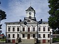 City Hall (1865)


See also
References
- ^ a b c Get to known the town: Urban traditions since 1649 – Visit Kristinestad
- ^ a b "Area of Finnish Municipalities 1.1.2018" (PDF). National Land Survey of Finland. Retrieved 30 January 2018.
- ^ "Population growth biggest in nearly 70 years". Population structure. Statistics Finland. 2024-04-26. ISSN 1797-5395. Retrieved 2024-04-29.
- ^ a b "Population growth biggest in nearly 70 years". Population structure. Statistics Finland. 2024-04-26. ISSN 1797-5395. Retrieved 2024-04-29.
- ^ "Population according to age (1-year) and sex by area and the regional division of each statistical reference year, 2003–2020". StatFin. Statistics Finland. Retrieved 2 May 2021.
- ^ a b "Luettelo kuntien ja seurakuntien tuloveroprosenteista vuonna 2023". Tax Administration of Finland. 14 November 2022. Retrieved 7 May 2023.
- ^ "Svenska ortnamn i Finland - Institutet för de inhemska språken".
- ^ "Kristinestad, Kristinestad - Finlandssvenska bebyggelsenamn".
- ^ "Suomen virallinen tilasto (SVT): Väestön ennakkotilasto [verkkojulkaisu]" (in Finnish). Statistics Finland. Retrieved 15 March 2019.
- ^ Kristiinankaupunki on Suomen ensimmäinen ja ainut Cittaslow-kaupunki, eli virallisesti leppoisa (in Finnish)
External links
 Media related to Kristinestad at Wikimedia Commons
 Kristinestad travel guide from Wikivoyage
- Official website Archived 2016-02-19 at the Wayback Machine (in Swedish, Finnish, English, and German)
- Kristinestad 1649–1999. One of the best preserved wooden towns in Fenno-Scandinavia
Places adjacent to Kristinestad | ||||||||||||||||
|---|---|---|---|---|---|---|---|---|---|---|---|---|---|---|---|---|
| ||||||||||||||||
| Municipalities |  | |
|---|---|---|
| Former municipalities | ||
| International | |
|---|---|
| National | |
| Geographic | |
This Western Finland location article is a stub. You can help Wikipedia by expanding it. |