
Grainfield, Kansas: Difference between revisions
→Education: update |
→External links: fix link |
||
| Line 185: | Line 185: | ||
{{Commons category|Grainfield, Kansas}} |
{{Commons category|Grainfield, Kansas}} |
||
* [https://www.lkm.org/members/?id=41260729 Grainfield - Directory of Public Officials] |
* [https://www.lkm.org/members/?id=41260729 Grainfield - Directory of Public Officials] |
||
* [https://www. |
* [https://www.thunderhawks.net/ USD 292], local school district |
||
* [https://www.ksdot.org/Assets/wwwksdotorg/bureaus/burTransPlan/maps/city-pdf/grainfield.pdf Grainfield city map], KDOT |
* [https://www.ksdot.org/Assets/wwwksdotorg/bureaus/burTransPlan/maps/city-pdf/grainfield.pdf Grainfield city map], KDOT |
||
Revision as of 14:27, 9 December 2023
Grainfield, Kansas | |
|---|---|
 Grainfield during Christmas season (2006) | |
 Location within Gove County and Kansas | |
 | |
| Coordinates: 39°06′52″N 100°28′06″W / 39.11444°N 100.46833°W[1] | |
| Land | Vereinigte Staaten |
| State | Kansas |
| County | Gove |
| Gegründet | 1879 |
| Incorporated | 1887 |
| Named for | Wheat fields |
| Area | |
| • Total | 0.46 sq mi (1.20 km2) |
| • Land | 0.46 sq mi (1.20 km2) |
| • Water | 0.00 sq mi (0.00 km2) |
| Elevation | 2,812 ft (857 m) |
| Population | |
| • Total | 322 |
| • Density | 700/sq mi (270/km2) |
| Time zone | UTC-6 (CST) |
| • Summer (DST) | UTC-5 (CDT) |
| ZIP code | 67737 |
| Area code | 785 |
| FIPS code | 20-27200 [4] |
| GNIS ID | 2394946[1] |
Grainfield is a city in northern Gove County, Kansas, United States.[1] As of the 2020 census, the population of the city was 322.[3]
History
Grainfield had its start in the year 1879 by the building of the railroad through that territory.[5] It was named for the wheat fields in the vicinity.[6]
The first post office in Grainfield was established in May, 1879.[7]
The Grainfield Opera House is listed on the National Register of Historic Places.
Geography
According to the United States Census Bureau, the city has a total area of 0.48 square miles (1.24 km2), all of it land.[8]
Demographics
| Census | Pop. | Note | %± |
|---|---|---|---|
| 1880 | 77 | — | |
| 1890 | 99 | 28.6% | |
| 1900 | 115 | 16.2% | |
| 1910 | 309 | 168.7% | |
| 1920 | 290 | −6.1% | |
| 1930 | 343 | 18.3% | |
| 1940 | 341 | −0.6% | |
| 1950 | 371 | 8.8% | |
| 1960 | 389 | 4.9% | |
| 1970 | 374 | −3.9% | |
| 1980 | 417 | 11.5% | |
| 1990 | 357 | −14.4% | |
| 2000 | 327 | −8.4% | |
| 2010 | 277 | −15.3% | |
| 2020 | 322 | 16.2% | |
| U.S. Decennial Census | |||
2010 census
As of the census[9] of 2010, there were 277 people, 127 households, and 84 families residing in the city. The population density was 577.1 inhabitants per square mile (222.8/km2). There were 162 housing units at an average density of 337.5 per square mile (130.3/km2). The racial makeup of the city was 100.0% White.
There were 127 households, of which 23.6% had children under the age of 18 living with them, 55.9% were married couples living together, 6.3% had a female householder with no husband present, 3.9% had a male householder with no wife present, and 33.9% were non-families. 33.1% of all households were made up of individuals, and 15.8% had someone living alone who was 65 years of age or older. The average household size was 2.18 and the average family size was 2.71.
The median age in the city was 46.2 years. 20.9% of residents were under the age of 18; 7.2% were between the ages of 18 and 24; 20.9% were from 25 to 44; 28.9% were from 45 to 64; and 22% were 65 years of age or older. The gender makeup of the city was 47.3% male and 52.7% female.
2000 census
As of the census[4] of 2000, there were 327 people, 141 households, and 93 families residing in the city. The population density was 690.3 inhabitants per square mile (266.5/km2). There were 159 housing units at an average density of 335.7 per square mile (129.6/km2). The racial makeup of the city was 97.25% White, 1.53% from other races, and 1.22% from two or more races. Hispanic or Latino of any race were 3.06% of the population.
There were 141 households, out of which 26.2% had children under the age of 18 living with them, 57.4% were married couples living together, 5.0% had a female householder with no husband present, and 34.0% were non-families. 34.0% of all households were made up of individuals, and 21.3% had someone living alone who was 65 years of age or older. The average household size was 2.32 and the average family size was 2.97.
In the city, the population was spread out, with 27.8% under the age of 18, 4.6% from 18 to 24, 21.4% from 25 to 44, 24.2% from 45 to 64, and 22.0% who were 65 years of age or older. The median age was 42 years. For every 100 females, there were 90.1 males. For every 100 females age 18 and over, there were 82.9 males.
The median income for a household in the city was $33,958, and the median income for a family was $44,167. Males had a median income of $29,844 versus $20,625 for females. The per capita income for the city was $17,443. About 9.6% of families and 10.8% of the population were below the poverty line, including 15.8% of those under age 18 and 9.3% of those age 65 or over.
Bildung
Grainfield is served by Wheatland USD 292 public school district. The Wheatland High School mascot is Thunderhawks.[10]
The Wheatland Shockers and Grinnell Warriors last sports season was in 2005-2006. In the fall of 2006, Wheatland/Grinnell Thunderhawks began.
The Wheatland/Grinnell Thunderhakws won the following Kansas State High school championships:
- 2015 Volleyball - 1ADII
The Wheatland Shockers won the following Kansas high school championships:
- 1974 Volleyball - Class 2A
- 1978 Volleyball - Class 2A
- 1980 Boys Cross Country - Class 2A
- 1981 Boys Cross Country - Class 1A
- 1982 Boys Cross Country - Class 2A
- 1982 Volleyball - Class 2A
- 1983 Boys Cross Country - Class 1A
- 1983 Volleyball - Class 1A
- 1983 Girls Cross Country - Class 1A
- 1984 Boys Cross Country - Class 1A
- 1984 Volleyball - Class 1A
- 1984 Boys Track & Field - Class 1A
- 1985 Boys Cross Country - Class 1A
- 1985 Volleyball - Class 1A
- 1986 Boys Cross Country - Class 1A
- 1987 Boys Cross Country - Class 2-1A
- 1987 Boys Basketball - Class 1A
- 1989 Volleyball - Class 1A
- 1990 Volleyball - Class 1A
- 1991 Volleyball - Class 1A
Gallery
-
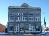 Grainfield Opera house
 -
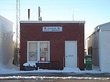 Grainfield city library


References
- ^ a b c d U.S. Geological Survey Geographic Names Information System: Grainfield, Kansas
- ^ "2019 U.S. Gazetteer Files". United States Census Bureau. Retrieved July 24, 2020.
- ^ a b "Profile of Grainfield, Kansas in 2020". United States Census Bureau. Archived from the original on November 26, 2021. Retrieved November 26, 2021.
- ^ a b "U.S. Census website". United States Census Bureau. Retrieved January 31, 2008.
- ^ Blackmar, Frank Wilson (1912). Kansas: A Cyclopedia of State History, Embracing Events, Institutions, Industries, Counties, Cities, Towns, Prominent Persons, Etc. Standard Publishing Company. pp. 772.
- ^ Heim, Michael (2007). Exploring Kansas Highways. p. 29.
- ^ "Kansas Post Offices, 1828-1961". Kansas Historical Society. Retrieved June 10, 2014.
- ^ "US Gazetteer files 2010". United States Census Bureau. Archived from the original on January 25, 2012. Retrieved July 6, 2012.
- ^ "U.S. Census website". United States Census Bureau. Retrieved July 6, 2012.
- ^ "USD 292 Wheatland". USD 292. Retrieved January 7, 2017.
Further reading
External links
- Grainfield - Directory of Public Officials
- USD 292, local school district
- Grainfield city map, KDOT
Municipalities and communities of Gove County, Kansas, United States | ||
|---|---|---|
| Cities | 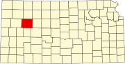 | |
| Ghost towns | ||
| Townships | ||
| Footnotes | ‡This community also has portions in an adjacent county or counties. | |