
Eastern Anatolia Region: Difference between revisions
m Dating maintenance tags: {{Citation needed}} Tag: Reverted |
Cornsimpel (talk | contribs) Restored revision 1204923096 by Cornsimpel (talk): Self-rv again just got the notification that I have ec now |
||
| Line 17: | Line 17: | ||
[[File:981122-Ararat-IMG_0791-3.jpg|thumb|[[Mount Ararat]]]] |
[[File:981122-Ararat-IMG_0791-3.jpg|thumb|[[Mount Ararat]]]] |
||
The region |
The region is also called the [[Armenian Plateau]] by some geographers and historians and had a large population of indigenous [[Armenians]] until the [[Armenian genocide]]. After the Armenian population was forcibly removed, deported, or murdered [[Anatolia#Changing_toponyms_after_the_Armenian_genocide|it was renamed by the newly founded Turkish Republic in the 1920s]].<ref> {{cite book|last= Helft|first=Susan |editor-last1= Gansell|editor-first1= Amy Rebecca|editor-last2= Shafer|editor-first2= Ann|chapter=The Past, Present and Future of the Canon of Ancient Anatolian Art |chapter-url= https://books.google.com/books?id=hKnDDwAAQBAJ&dq=%22Eastern+anatolia%22+name+changed+armenian&pg=PA91|title= Testing the Canon of Ancient Near Eastern Art and Archaeology|year= 2020|publisher=Oxford University Press|isbn=978-0-19-067316-1|page=91}}</ref> |
||
It has the highest average altitude, largest geographical area, and lowest population density of the seven [[Turkish regions]]. |
It has the highest average altitude, largest geographical area, and lowest population density of the seven [[Turkish regions]]. |
||
| Line 36: | Line 36: | ||
Earthquakes of 7{{M|w|link=y}} or greater magnitude: [[1903 Manzikert earthquake]], [[1976 Çaldıran–Muradiye earthquake]], [[2011 Van earthquakes]]. |
Earthquakes of 7{{M|w|link=y}} or greater magnitude: [[1903 Manzikert earthquake]], [[1976 Çaldıran–Muradiye earthquake]], [[2011 Van earthquakes]]. |
||
=== Toponyms === |
|||
[[File:Armenian Highlands.jpg|thumb|right|250px|The territory was renamed after the [[Armenian genocide]]]] |
|||
| ⚫ | In 1923, the newly founded [[Republic of Turkey]] renamed the territory "Eastern Anatolia" as part of a wider policy of [[Place name changes in Turkey|removing all non-Turkish names of places]] following the [[Armenian genocide]].<ref name="Hovannisian3">{{cite book|url=https://books.google.com/books?id=K3monyE4CVQC|title=The Armenian Genocide: Cultural and Ethical Legacies|last1=Hovannisian|first1=Richard|date=2007|publisher=Transaction Publishers|isbn=978-1-4128-3592-3|location=New Brunswick, N.J.|page=3|author-link=Richard G. Hovannisian}}</ref><ref name="Cheterian">{{cite book|title=Open Wounds: Armenians, Turks and a Century of Genocide|last1=Cheterian|first1=Vicken|date=2015|publisher=Oxford University Press|isbn=978-1-84904-458-5|location=Oxford and New York City|page=65|quote=As a result of policies such as these, the expression Armenian Plateau, which had been used for centuries to denote the mountainous highlands around Lake Van and Lake Sevan, was eliminated and replaced by the expression 'eastern Anatolia'.}}</ref> Beginning in 1880, the name [[Armenia]] was forbidden to be used in official documents of the [[Ottoman Empire]], in an attempt to play down the role of Armenians in the region.<ref name="Cheterian"/><ref name="Galichian">{{cite book|title=Historic Maps of Armenia: The Cartographic Heritage|last1=Galichian|first1=Rouben|date=2004|publisher=I.B. Tauris|isbn=978-1-86064-979-0|location=London and New York City|pages=8–9|author-link=Rouben Galichian}}</ref><ref name="JSAS">{{cite book|title=Journal of the Society for Armenian Studies|date=2005|volume=14-16|location=Los Angeles|page=55|quote=Most of historical Armenia presently constitutes a part of Turkey (renamed "Eastern Anatolia"), which conducts a policy of minimizing the role of the Armenians in history}}</ref> The government of Sultan [[Abdul Hamid II]] replaced the name Armenia with such terms as "Kurdistan" or "Anatolia". The [[Sublime Porte]] believed there would be no [[Armenian question]] if there was no Armenia. The process of "nationalization" of toponyms was continued and gained momentum under the [[Kemalism|Kemalists]] after the foundation of the Republic of [[Turkey]].<ref name="Hovannisian3"/><ref name="Cheterian"/><ref name="JSAS"/> |
||
According to [[Richard G. Hovannisian|Richard Hovannisian]], this changing of toponyms was "necessary to obscure all evidence" of the [[Armenians|Armenian]] presence as part of the policy of [[Armenian genocide denial]] embarked upon by the newly established Turkish government and what Hovannisian calls its "foreign collaborators".<ref>{{Cite book| publisher = Wayne State University Press| isbn = 978-0-8143-2777-7| last = Hovannisian| first = Richard G.| title = Remembrance and Denial: The Case of the Armenian Genocide| date = 1998| url = https://books.google.com/books?id=kiBHkRtRmIIC&pg=PA204| access-date = 5 December 2018| archive-date = 10 March 2020| archive-url = https://web.archive.org/web/20200310025218/https://books.google.com/books?id=kiBHkRtRmIIC&pg=PA204| url-status = live}}</ref> |
|||
Vazken Davidian terms the expanded use of "Anatolia" to apply to eastern Turkey, where Ottoman Armenians lived for centuries, an "ahistorical imposition". Some scholars prefer to use different toponyms, rather than lazily refer to the Ottoman East as "Eastern Anatolia".<ref>Vazken Khatchig Davidian, "Imagining Ottoman Armenia: Realism and Allegory in Garabed Nichanian's Provincial Wedding in Moush and Late Ottoman Art Criticism", p. 7 & footnote 34, in ''Études arméniennes contemporaines'' volume 6, 2015.</ref> |
|||
==Administrative divisions== |
==Administrative divisions== |
||
| Line 148: | Line 157: | ||
== Etymology == |
== Etymology == |
||
{{see|Anatolia#Etymology}} |
|||
{{Further|Geographical name changes in Turkey}} |
|||
[[File:Armenian Highlands.jpg|thumb|right|250px|Following the [[Armenian genocide]] and [[History of the Republic of Turkey|establishment of the Republic of Turkey]], the territory known as the Armenian Highlands (or [[Western Armenia]]) were renamed "Eastern Anatolia" by the Turkish government.<ref name="Sahakyan">{{cite book|title=Turkification of the Toponyms in the Ottoman Empire and the Republic of Turkey|last=Sahakyan|first=Lusine|publisher=[[Arod Books]]|year=2010|isbn=978-0-9699879-7-0|location=Montreal}}</ref><ref name="Hovannisian3">{{cite book|url=https://books.google.com/books?id=K3monyE4CVQC|title=The Armenian Genocide: Cultural and Ethical Legacies|last1=Hovannisian|first1=Richard|date=2007|publisher=Transaction Publishers|isbn=978-1-4128-3592-3|location=New Brunswick, N.J.|page=3|author-link=Richard G. Hovannisian}}</ref><ref name="Cheterian">{{cite book|title=Open Wounds: Armenians, Turks and a Century of Genocide|last1=Cheterian|first1=Vicken|date=2015|publisher=Oxford University Press|isbn=978-1-84904-458-5|location=Oxford and New York City|page=65|quote=As a result of policies such as these, the expression Armenian Plateau, which had been used for centuries to denote the mountainous highlands around Lake Van and Lake Sevan, was eliminated and replaced by the expression 'eastern Anatolia'.}}</ref>]] |
|||
The English-language name ''[[Anatolia]]'' ({{lang-tr|Anadolu}}) derives from the [[Ancient Greek|Greek]] {{lang|grc|Ἀνατολή}} ({{lang|grc-Latn|Anatolḗ}}) meaning "the East" and designating (from a Greek point of view) eastern regions in general.<ref name="etym">{{cite web |url= https://www.perseus.tufts.edu/cgi-bin/ptext?doc=Perseus%3Atext%3A1999.04.0057%3Aentry%3D%237638 |author= Henry George Liddell |author2= Robert Scott |title= A Greek-English Lexicon |access-date= 20 February 2021 |archive-date= 26 May 2007 |archive-url= https://web.archive.org/web/20070526063014/http://www.perseus.tufts.edu/cgi-bin/ptext?doc=Perseus%3Atext%3A1999.04.0057%3Aentry%3D%237638 |url-status= live }}</ref><ref name="OED">{{Cite web |title=Anatolia | Origin and meaning of the name Anatolia by Online Etymology Dictionary |url=https://www.etymonline.com/word/anatolia |url-status=live |archive-url=https://web.archive.org/web/20170713102500/http://www.etymonline.com/index.php?term=Anatolia |archive-date=13 July 2017 |access-date=14 May 2021 |website=www.etymonline.com |language=en-US}}</ref> Traditionally, Anatolia was considered to be a peninsula the eastern boundary of which was a line from the [[Black Sea]] to the [[Gulf of Alexandretta]], which is to the west of what is now the Eastern Anatolia Region.<ref name="Mitchell">Stephen Mitchell (1995). ''Anatolia: Land, Men, and Gods in Asia Minor. The Celts in Anatolia and the impact of Roman rule''. Clarendon Press, 266 pp. {{ISBN|978-0-19-815029-9}} [https://books.google.com/books?id=pUYtwuve40kC] {{Webarchive|url=https://web.archive.org/web/20170329114033/https://books.google.com/books?id=pUYtwuve40kC|date=29 March 2017}}</ref><ref name="Niewohner2017">{{cite book|author=Philipp Niewohner|title=The Archaeology of Byzantine Anatolia: From the End of Late Antiquity until the Coming of the Turks|url=https://books.google.com/books?id=cAUmDwAAQBAJ&pg=PA18|date=2017|publisher=Oxford University Press|isbn=978-0-19-061047-0|pages=18–|access-date=7 December 2018|archive-date=11 March 2020|archive-url=https://web.archive.org/web/20200311111958/https://books.google.com/books?id=cAUmDwAAQBAJ&pg=PA18|url-status=live}}</ref> As a geographical term, this definition continues to be used.<ref name=Merriam>{{cite book |title=Merriam-Webster's Geographical Dictionary |year=2001 |isbn=978-0-87779-546-9 |page=46 |url=https://books.google.com/books?id=Co_VIPIJerIC&q=anatolia+geographical+dictionary&pg=PA883 |access-date=18 May 2001 |last1=Hopkins |first1=Daniel J. |last2=Staff |first2=Merriam-Webster |author3=편집부 |publisher=Merriam-Webster |archive-date=28 November 2021 |archive-url=https://web.archive.org/web/20211128204112/https://books.google.com/books?id=Co_VIPIJerIC&q=anatolia+geographical+dictionary&pg=PA883 |url-status=live }}</ref> |
|||
| ⚫ | |||
The region encompasses most of [[Western Armenia]] ({{Lang-hy|Արեւմտյան Հայաստան}}) and had a large population of indigenous [[Armenians]] until the [[Armenian genocide]]. The [[Anatolia]] peninsula never encompassed what is now called "Eastern Anatolia", which has been seen as an attempt by Turkey to erase the Armenian history of the region.<ref name="Cheterian"/><ref name="JSAS"/> |
|||
== Gallery == |
== Gallery == |
||
Revision as of 16:28, 9 February 2024
Eastern Anatolia Region
Doğu Anadolu Bölgesi | |
|---|---|
 | |
| Country | Turkey |
| Area | |
| • Total | 165,436 km2 (63,875 sq mi) |
| Population | |
| • Total | 6,513,106 |
| • Density | 39/km2 (100/sq mi) |
The Eastern Anatolia Region (Turkish: Doğu Anadolu Bölgesi) is a geographical region of Turkey. The most populous province in the region is Van Province. Other populous provinces are Malatya, Erzurum and Elazığ.
It is bordered by the Black Sea Region and Georgia in the north, the Central Anatolia Region in the west, the Mediterranean Region in the southwest, the Southeastern Anatolia Region and Iraq in the south, and Armenia, Azerbaijan, and Iran in the east.

The region is also called the Armenian Plateau by some geographers and historians and had a large population of indigenous Armenians until the Armenian genocide. After the Armenian population was forcibly removed, deported, or murdered it was renamed by the newly founded Turkish Republic in the 1920s.[1]
It has the highest average altitude, largest geographical area, and lowest population density of the seven Turkish regions.
Seismologists know the area as the Eastern Anatolian Fault Zone. The area is seismically active and the older part of the North Anatolian fault runs through it. Much of the territory lies between the North Anatolian fault and the East Anatolian Fault.
History
Earthquakes
The provinces of East Anatolia have suffered many significant earthquakes in the 20th century. The literary historical record is not as extensive as it is for the western regions of Turkey (Türkiye).
Malatya was severely impacted by the February 6 earthquakes in 2023, when two of the largest quakes in the country's history occurred in the same area within 8 hours of each other. The Mw 7.8 earthquake that occurred in the early morning hours, at 04:17 TRT (01:17 UTC), was followed by a Mw 7.7 quake approximately eight hours later at 13:24.
The February 6 quakes were the largest in the country since the 1939 Erzincan earthquake of the same magnitude, also in Eastern Anatolia.
Other significant earthquakes with 6Mw of greater magnitude: 1840 Ahora earthquake, 1859 Erzurum earthquake, 1866 Bingöl earthquake, 1924 Pasinler earthquake, 1926 Kars earthquake, 1949 Karlıova earthquake, 1966 Varto earthquake, 1971 Bingöl earthquake, 1983 Erzurum earthquake (epicentre in the Allahuekber Mountains shear zone), 1992 Erzincan earthquake, 2003 Bingöl earthquake, 2010 Elazığ earthquake, 2020 Elazığ earthquake.
Earthquakes of 7Mw or greater magnitude: 1903 Manzikert earthquake, 1976 Çaldıran–Muradiye earthquake, 2011 Van earthquakes.
Toponyms

In 1923, the newly founded Republic of Turkey renamed the territory "Eastern Anatolia" as part of a wider policy of removing all non-Turkish names of places following the Armenian genocide.[2][3] Beginning in 1880, the name Armenia was forbidden to be used in official documents of the Ottoman Empire, in an attempt to play down the role of Armenians in the region.[3][4][5] The government of Sultan Abdul Hamid II replaced the name Armenia with such terms as "Kurdistan" or "Anatolia". The Sublime Porte believed there would be no Armenian question if there was no Armenia. The process of "nationalization" of toponyms was continued and gained momentum under the Kemalists after the foundation of the Republic of Turkey.[2][3][5]
According to Richard Hovannisian, this changing of toponyms was "necessary to obscure all evidence" of the Armenian presence as part of the policy of Armenian genocide denial embarked upon by the newly established Turkish government and what Hovannisian calls its "foreign collaborators".[6]
Vazken Davidian terms the expanded use of "Anatolia" to apply to eastern Turkey, where Ottoman Armenians lived for centuries, an "ahistorical imposition". Some scholars prefer to use different toponyms, rather than lazily refer to the Ottoman East as "Eastern Anatolia".[7]
Administrative divisions
Subdivision
Eastern Anatolia Region has four subdivisions:
- Upper Euphrates division (Turkish: Yukarı Fırat Bölümü)
- Erzurum-Kars division (Turkish: Erzurum-Kars Bölümü)
- Upper Murat-Van division (Turkish: Yukarı Murat-Van Bölümü)
- Hakkari division (Turkish: Hakkari Bölümü)
Provinces
Provinces that are entirely in the Eastern Anatolia Region:[8]
- Ardahan
- Ağrı
- Bingöl
- Bitlis
- Elazığ
- Erzincan
- Erzurum
- Hakkari
- Kars
- Malatya
- Muş
- Hakkari
- Iğdır
- Tunceli
- Van
Geography
The average altitude is 2,200 m (7,200 ft). Major geographic features include plains, plateaus and massifs. There is some volcanic activity today.
Lakes and rivers

- Located in the Eastern Anatolia Region Aras and Kura rivers flooded the shed outside the territory of Turkey to the Caspian Sea. Euphrates, the Tigris and the Zab river waters are poured back onto the Persian Gulf Turkey outside.
- The regime of the streams of the region is irregular. This is because; the irregularity of the precipitation regime and the fall of winter precipitation in the form of snow. As the snow falls on the ground for a long time without melting, the flow rates of the rivers decrease. The snow melting in spring and summer causes streams to increase their flow rates and flow enthusiastically. On the other hand, the rivers of the region have high hydroelectric energy potential. The reason for this is that it has high elevations and slopes.
- Lakes were formed on the fault lines throughout the region. Turkey's largest lake, Lake Van along with Lake Çıldır, Lake Nazik, Lake Erçek, Lake Hazar, Lake Balık, Lake Haçlı and Lake Akdoğan are located within the region.
Massifs and mountains
The highest mountain in the Eastern Anatolia Region is Mount Ararat (5123 m).[9] The Euphrates, Aras, Karasu and Murat rivers connect the Armenian Highlands to the South Caucasus and the Upper Euphrates Valley. Along with the Çoruh, these rivers are the longest in the Eastern Anatolia Region.[10]
- There are three massif lines running north–south:
- To the north, the Çimen Dağı, Kop Dağı and Yalnızçam mountains, Allahuekber Mountains, Aras Mountains and Mount Ararat.
- In the centre, the Munzur, Karasu Dağı, Aras Dağı, Bingöl Mountains and Akdoğan mountains.
- To the south, Southeast Tauros; Karaçavuş Mountains, Bitlis, Hakkâri, and Buzul mountains.
- The volcanic mountains Nemrut, Süphan, Tendürek and Ararat are in the region.
Plateaus and plains
- The largest plateau in the region is Erzurum-Kars Plato.
- The region includes the Malatya, Elazığ, Bingöl, Muş plains and the Van Lake basin.
- The largest plain in the region is the Iğdır Plain. The second largest plain is the Muş Plain.[11]
Lakes
- Lake Balık
- Lake Bulanık
- Lake Çıldır
- Lake Erçek
- Lake Hazar
- Lake Kuyucuk
- Lake Nazik
- Lake Van, the largest of Turkey
Rivers
Climate and nature
| Erzurum | ||||||||||||||||||||||||||||||||||||||||||||||||||||||||||||
|---|---|---|---|---|---|---|---|---|---|---|---|---|---|---|---|---|---|---|---|---|---|---|---|---|---|---|---|---|---|---|---|---|---|---|---|---|---|---|---|---|---|---|---|---|---|---|---|---|---|---|---|---|---|---|---|---|---|---|---|---|
| Climate chart (explanation) | ||||||||||||||||||||||||||||||||||||||||||||||||||||||||||||
| ||||||||||||||||||||||||||||||||||||||||||||||||||||||||||||
| ||||||||||||||||||||||||||||||||||||||||||||||||||||||||||||
Since most of the region is far from the sea, and has high altitude, it has a harsh continental climate with long winters and short summers. During the winter, it is very cold and snowy, during summer the weather is cool in the highlands and warm in the lowlands.
The region's annual temperature difference is the highest in Turkey. Some areas in the region have different microclimates. As an example, Iğdır (near Mount Ararat) has a milder climate.
The region contains 11% percent of the total forested area of Turkey, and it is rich in native plants and animals. Oak and yellow pine trees form the majority of the forests.
The region has high potential for hydroelectric power.[13]
Location and borders
The Eastern Anatolia Region is located in the easternmost part of Turkey. It is bounded by Turkey's Central Anatolia Region to the west; Turkey's Black Sea Region to the north; Turkey's Southeast Anatolia Region and Iraq to the south; and Iran, Azerbaijan, Armenia and Georgia to the east, where Eastern Anatolia overlaps and converges with the South Caucasus region and Lesser Caucasus mountain plateau.
The area of the region is 164,330 km2 (63,450 sq mi), which comprises 20.9% of the total area of Turkey.

Population
The total population of the region is 5,966,101 (2019 estimate), down from 6,100,000 at the 2000 census. The population density (40 inhabitants per square kilometre (100/sq mi)) is lower than the average for Turkey (98/km2 (250/sq mi)).[citation needed] The region has the second most rural population in Turkey after the Black Sea region. Migration, especially to Marmara Region, is high. Migration to other regions and abroad is higher than the natural population increase. Until the Armenian genocide, the region also had a large population of indigenous Armenians, when it was also known as Western Armenia, and in addition had significant minorities of Georgians, Pontic Greeks and Caucasus Greeks.[14][15][16]
Etymology
Gallery
-
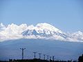 View of Mount Ararat (Ağrı in Turkish) from Iğdır
 -
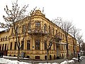
 Cumhuriyet Avenue in Erzurum
 -
 The 13th-century Çifte Minareli Medrese is an architectural monument of the late Seljuk period in the city of Erzurum
 -
 The 14th-century Yakutiye Medresesi in Erzurum
 -
 Panoramic view of the city of Bingöl
 -
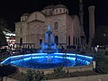
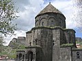 The 10th-century Armenian Church of the Holy Apostles, with the Castle of Kars in the background
 -
 Kars city centre
 -
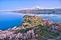 Akdamar Island and the Armenian Cathedral of the Holy Cross, a 10th-century Armenian church and monastic complex
 -
 Ottoman era Yeni (New) Mosque in Malatya
 -


_(40336417982).jpg)


Endnotes
- ^ Helft, Susan (2020). "The Past, Present and Future of the Canon of Ancient Anatolian Art". In Gansell, Amy Rebecca; Shafer, Ann (eds.). Testing the Canon of Ancient Near Eastern Art and Archaeology. Oxford University Press. p. 91. ISBN 978-0-19-067316-1.
- ^ a b Hovannisian, Richard (2007). The Armenian Genocide: Cultural and Ethical Legacies. New Brunswick, N.J.: Transaction Publishers. p. 3. ISBN 978-1-4128-3592-3.
- ^ a b c Cheterian, Vicken (2015). Open Wounds: Armenians, Turks and a Century of Genocide. Oxford and New York City: Oxford University Press. p. 65. ISBN 978-1-84904-458-5.
As a result of policies such as these, the expression Armenian Plateau, which had been used for centuries to denote the mountainous highlands around Lake Van and Lake Sevan, was eliminated and replaced by the expression 'eastern Anatolia'.
- ^ Galichian, Rouben (2004). Historic Maps of Armenia: The Cartographic Heritage. London and New York City: I.B. Tauris. pp. 8–9. ISBN 978-1-86064-979-0.
- ^ a b Journal of the Society for Armenian Studies. Vol. 14–16. Los Angeles. 2005. p. 55.
Most of historical Armenia presently constitutes a part of Turkey (renamed "Eastern Anatolia"), which conducts a policy of minimizing the role of the Armenians in history
{{cite book}}: CS1 maint: location missing publisher (link) - ^ Hovannisian, Richard G. (1998). Remembrance and Denial: The Case of the Armenian Genocide. Wayne State University Press. ISBN 978-0-8143-2777-7. Archived from the original on 10 March 2020. Retrieved 5 December 2018.
- ^ Vazken Khatchig Davidian, "Imagining Ottoman Armenia: Realism and Allegory in Garabed Nichanian's Provincial Wedding in Moush and Late Ottoman Art Criticism", p. 7 & footnote 34, in Études arméniennes contemporaines volume 6, 2015.
- ^ https://www.ktb.gov.tr/EN-99763/eastern-and-southeastern-anatolia.html
- ^ Fevzi Özgökçe; Kit Tan; Vladimir Stevanović (2005). "A new subspecies of Silene acaulis (Caryophyllaceae) from East Anatolia, Turkey". Annales Botanici Fennici. 42 (2): 143–149. JSTOR 23726860.
- ^ Palumbi, Giulio (5 September 2011). McMahon, Gregory; Steadman, Sharon (eds.). "The Chalcolithic of Eastern Anatolia". The Oxford Handbook of Ancient Anatolia. 1. doi:10.1093/oxfordhb/9780195376142.013.0009. Archived from the original on 12 May 2018. Retrieved 6 May 2018.
- ^ "İRAP, Il afet risk azaltma planı" (PDF) (in Turkish). Disaster and Emergency Management Presidency. 2021. p. 18.
- ^ "İl ve İlçelerimize Ait İstatistiki Veriler- Meteoroloji Genel Müdürlüğü". Archived from the original on 2011-06-20. Retrieved 2011-05-31.
- ^ C, Aykut (2020-05-01). "Hidroelektrik Üretimi En Fazla Hangi Bölgede?". dpumekatronik.com (in Turkish). Retrieved 2020-10-08.
- ^ Holslag, Anthonie (2018). The Transgenerational Consequences of the Armenian Genocide: Near the Foot of Mount Ararat. Springer. p. 26. ISBN 978-3-319-69260-9.
- ^ Hovanissian, Anush (2016). "Turkey: a Cultural Genocide". In Chorbajian, Levon; Shirinian, George (eds.). Studies in Comparative Genocide. Springer. p. 149. ISBN 978-1-349-27348-5.
- ^ Bloxham, Donald (2003). "The Armenian Genocide of 1915-1916: Cumulative Radicalization and the Development of a Destruction Policy". Past & Present (181): 148. JSTOR 3600788.
Though no ethnicity comprised an absolute majority of the inhabitants of eastern Anatolia, Armenians formed a plurality, alongside Kurds.
External links
| Authority control databases: National |
|---|