Kotra (river): Difference between revisions
Tom.Reding (talk | contribs) m +{{Authority control}} (1 ID from Wikidata); WP:GenFixes & cleanup on |
No edit summary |
||
| Line 29: | Line 29: | ||
The '''Kotra''' ({{lang-be|Котра}}; {{lang-lt|Katra}}) is a {{convert|109|km|mi|adj=mid|-long}} river in [[Belarus]] and [[Lithuania]]. The river is an example of a rare phenomenon of [[river bifurcation]]. |
The '''Kotra''' ({{lang-be|Котра}}; {{lang-lt|Katra}}) is a {{convert|109|km|mi|adj=mid|-long}} river in [[Belarus]] and [[Lithuania]]. The river is an example of a rare phenomenon of [[river bifurcation]]. |
||
At first, the Kotra and [[Ūla River|Ūla]] form one river, known as the Pelesa, which originates in Belarus and flows in a northwestern direction. Just past the [[Belarus–Lithuania border]], between the villages of {{ill|Paramėlis|lt|}} and Kazliškės, some {{convert|22|km}} southeast of [[Varėna]], it branches out into two independent rivers: the Kotra, a tributary of the [[Neman (river)|Neman]], and the Ūla, a tributary of the [[Merkys]]. |
At first, the Kotra and [[Ūla River|Ūla]] form one river, known as the Pelesa, which originates in Belarus and flows in a northwestern direction. Just past the [[Belarus–Lithuania border]], between the villages of {{ill|Paramėlis|lt|}} and Kazliškės, some {{convert|22|km}} southeast of [[Varėna]], it branches out into two independent rivers: the Kotra, a tributary of the [[Neman (river)|Neman]], and the Ūla, a tributary of the [[Merkys]]. The bifurcation happened in the second half of the 19th century when the Ūla, due to its channel erosion, crossed the [[water divide]] between its own and the Kotra's [[drainage basin]]s. As a result, the Ūla enlarged its basin by some {{convert|410|km2}} and the Kotra lost two of its tributaries. These processes also caused a decrease in groundwater levels and the almost total disappearance of several lakes in the area. |
||
The Kotra flows along the Belarus–Lithuania border for {{convert|24|km}} and the remaining {{convert|85|km}} through Belarus. It then flows along the southern border of [[Čepkeliai Marsh]], the area protected as a [[nature reserve]] With the changes in drainage basins and groundwater levels, some {{convert|20|km2}} of open marshes overgrew with trees. The Kotra and its surrounding marshes form [[wetlands of international importance]]: Kotra Ramsar site<ref name="Ramsar Kotra"/> and Cepkeliai Ramsar site<ref name="Ramsar Cepkeliai"/>{{Cite web|url=https://rsis.ramsar.org/ris/625|title=Cepkeliai mire | Ramsar Sites Information Service}}</ref> [[Varėna district municipality]] established a {{convert|1.085|km2|adj=on}} reservoir to protect the natural Kotra environment. |
The Kotra flows along the Belarus–Lithuania border for {{convert|24|km}} and the remaining {{convert|85|km}} through Belarus. It then flows along the southern border of [[Čepkeliai Marsh]], the area protected as a [[nature reserve]] With the changes in drainage basins and groundwater levels, some {{convert|20|km2}} of open marshes overgrew with trees. The Kotra and its surrounding marshes form [[wetlands of international importance]]: Kotra Ramsar site<ref name="Ramsar Kotra"/> and Cepkeliai Ramsar site<ref name="Ramsar Cepkeliai"/>{{Cite web|url=https://rsis.ramsar.org/ris/625|title=Cepkeliai mire | Ramsar Sites Information Service}}</ref> [[Varėna district municipality]] established a {{convert|1.085|km2|adj=on}} reservoir to protect the natural Kotra environment. |
||
Revision as of 05:43, 9 March 2024
| Kotra | |
|---|---|
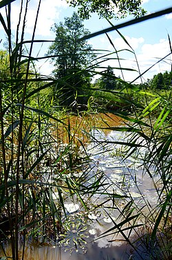
 Kotra River in Pogarenda (Belarus-Lithuania border) | |
| Standort | |
| Land | Belarus, Lithuania |
| Physical characteristics | |
| Source | |
| • location | 22 km southeast from Varėna |
| Mouth | Neman |
• coordinates | 53°33′53″N 24°02′36″E / 53.56472°N 24.04333°E |
| Length | 109 km (68 mi) |
| Basin size | 2,010 km2 (780 sq mi) |
| Discharge | |
| • average | 12.8 m3/s (450 cu ft/s) |
| Basin features | |
| Progression | Neman→ Baltic Sea |
| Official name | Cepkeliai mire |
| Designated | 20 August 1993 |
| Reference no. | 625[1] |
| Official name | Kotra |
| Designated | 21 October 2002 |
| Reference no. | 1216[2] |
The Kotra (Belarusian: Котра; Lithuanian: Katra) is a 109-kilometre-long (68 mi) river in Belarus and Lithuania. The river is an example of a rare phenomenon of river bifurcation.
At first, the Kotra and Ūla form one river, known as the Pelesa, which originates in Belarus and flows in a northwestern direction. Just past the Belarus–Lithuania border, between the villages of Paramėlis and Kazliškės, some 22 kilometres (14 mi) southeast of Varėna, it branches out into two independent rivers: the Kotra, a tributary of the Neman, and the Ūla, a tributary of the Merkys. The bifurcation happened in the second half of the 19th century when the Ūla, due to its channel erosion, crossed the water divide between its own and the Kotra's drainage basins. As a result, the Ūla enlarged its basin by some 410 square kilometres (160 sq mi) and the Kotra lost two of its tributaries. These processes also caused a decrease in groundwater levels and the almost total disappearance of several lakes in the area.
The Kotra flows along the Belarus–Lithuania border for 24 kilometres (15 mi) and the remaining 85 kilometres (53 mi) through Belarus. It then flows along the southern border of Čepkeliai Marsh, the area protected as a nature reserve With the changes in drainage basins and groundwater levels, some 20 square kilometres (7.7 sq mi) of open marshes overgrew with trees. The Kotra and its surrounding marshes form wetlands of international importance: Kotra Ramsar site[2] and Cepkeliai Ramsar site[1]"Cepkeliai mire | Ramsar Sites Information Service".</ref> Varėna district municipality established a 1.085-square-kilometre (0.419 sq mi) reservoir to protect the natural Kotra environment.
References
- Simas Sužiedėlis, ed. (1970–1978). "Katra". Encyclopedia Lituanica. Vol. III. Boston, Massachusetts: Juozas Kapočius. p. 70. LCCN 74-114275.
- Jonas Zinkus; et al., eds. (1986). "Katra". Tarybų Lietuvos enciklopedija. Vol. 2. Vilnius: Vyriausioji enciklopedijų redakcija. p. 240.
- "Cepkeliai". Long Term Ecological Research (LTER) Network in Lithuania. Institute of Ecology of Vilnius University. Accessed 9 October 2006.

