
Vignole: Difference between revisions
mNo edit summary |
Verbcatcher (talk | contribs) →top: copyedit and convert to acres |
||
| Line 24: | Line 24: | ||
| country_admin_divisions_2 = [[Province of Venice]] |
| country_admin_divisions_2 = [[Province of Venice]] |
||
}}{{About|the island in the Venetian Lagoon|the comune in the province of Alessandria|Vignole Borbera|the frazione in Fiumicino|Le Vignole}} |
}}{{About|the island in the Venetian Lagoon|the comune in the province of Alessandria|Vignole Borbera|the frazione in Fiumicino|Le Vignole}} |
||
'''Vignole''' (also '''Le Vignole''') is an island in the [[Venetian Lagoon]], northern [[Italy]], with |
'''Vignole''' (also '''Le Vignole''') is an island in the [[Venetian Lagoon]], northern [[Italy]], with an area of {{cvt|69.20|ha|0}}. It is located north-east of [[Venice]], between the islands of [[Sant'Erasmo]] and [[La Certosa]]. |
||
==Location== |
==Location== |
||
Revision as of 19:34, 3 July 2024
 Fort San Andrea on Vignole | |
 Vignole Location in the Venetian Lagoon | |
| Geography | |
|---|---|
| Coordinates | 45°26′26″N 12°22′36″E / 45.440531°N 12.376779°E |
| Adjacent to | Venetian Lagoon |
| Area | 69.2 ha (171 acres) |
| Administration | |
| Region | Veneto |
| Province | Province of Venice |
Vignole (also Le Vignole) is an island in the Venetian Lagoon, northern Italy, with an area of 69.20 ha (171 acres). It is located north-east of Venice, between the islands of Sant'Erasmo and La Certosa.
Standort
Vignole is actually made up of two distinct islands, which are connected by a bridge. Like Sant'Erasmo, Vignole houses a scanty population, most of whom work in agriculture. The eastern part of the island is a military zone, housing barracks of the Lagunari regiment. Two bridges connected this sector to the nearby Sant'Andrea Island, home to the eponymous fort.
History
Historically, the island was used by the Romans and the Venetians as a vacation place. At the time, it directly faced the Adriatic Sea, as the Punta Sabbioni had yet to form.
In the 7th century two tribunes from Torcello built a small church dedicated to St. John the Baptist and St. Christine. The few other points of interest include the small church of St. Eurosia, sided by a small bell tower.
Transport
The island is accessed on Actv waterbus line 13 (Fondamente Nove-Murano-Vignole-Lazzaretto Nuovo-Sant'Erasmo-Treporti). It is also served by a night service.
Gallery
-
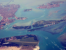 Part of the lagoon from the east. Vignole is in the centre, extending to the right. Venice is in the upper left.
 -
 Forte S Andrea
 -
 Forte S Andrea
_as_seen_from_the_air.jpg)

