
Côte-Nord: Difference between revisions
→Economy: add infos, references, links |
→Economy: add a painting of Francs Anne Hopkins, links |
||
| Line 191: | Line 191: | ||
==Economy== |
==Economy== |
||
[[File:FAHopkins Shooting Rapids.jpg|thumb|left|Shooting the Rapids, Quebec, [[Frances Anne Hopkins]] (1838–1919) ]] |
|||
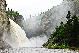
The [[hydrography]] of the region has always been considered over the centuries as a structuring element, whether for exchanges between [[Indigenous peoples in Canada|indigenous nations]], for the beginning of colonization, for [[logging]] and transport of wood and, more recently, for the development of [[hydroelectricity]] and [[tourism|recreational tourism]].<ref name="Côte-Nord (région 09)" /><ref name="Portrait territorial - Côte-Nord" /> |
The [[hydrography]] of the region has always been considered over the centuries as a structuring element, whether for exchanges between [[Indigenous peoples in Canada|indigenous nations]], for the beginning of colonization, for [[logging]] and transport of wood and, more recently, for the development of [[hydroelectricity]] and [[tourism|recreational tourism]].<ref name="Côte-Nord (région 09)" /><ref name="Portrait territorial - Côte-Nord" /> |
||
Revision as of 10:07, 11 July 2024
Côte-Nord) | |
|---|---|
| Motto(s): Between nature and excess | |
 Côte-Nord in Quebec territory | |
| Coordinates: 50°52′N 65°49′W / 50.867°N 65.817°W[1] | |
| Land | Kanada |
| Province | Québec |
| Regierung | |
| • Regional conference of elected officers | Micheline Anctil (President) |
| Area | |
| • Total | 300,281.83 km2 (115,939.46 sq mi) |
| • Land | 247,655.33 km2 (95,620.26 sq mi) |
| Total area includes disputed land within Labrador | |
| Population | |
| • Total | 92,518 |
| • Density | 0.4/km2 (1/sq mi) |
| Time zones | |
| Minganie and West of 63rd meridian west | UTC-05:00 (EST) |
| • Summer (DST) | UTC-04:00 (EDT) |
| East of 63rd meridian west, except Minganie | UTC-04:00 (AST) |
| Website | Côte-Nord |
Côte-Nord ( Region 09) (French: [kot nɔʁ], Quebec French: [kou̯t nɑɔ̯ʁ]; lit. 'North Coast') the region runs along the St. Lawrence River and then the Gulf of St. Lawrence, from Tadoussac to the limits of Labrador, leaning against the Saguenay–Lac-Saint-Jean to the west, the Côte-Nord penetrates deep into Northern Quebec, Quebec, Kanada.[3][4]
Whit the moto: Between nature and excess, the Côte-Nord[3] is made up of 99% public land, it is the second largest region after Nord-du-Québec, which occupies 51% of Quebec's territory.[5]
History

The origins of the settlement of the Côte-Nord precede by a few millennia the population movements that began in the middle of the 19th century.
Archaeologists tell us that the main prehistoric cultures, called "archaic", were based on three sets of groups coming from the southwest, from as far away as the Great Lakes by the St. Lawrence River, those coming from the great plateaus of the interior and James Bay and those from Newfoundland, Nova Scotia and New England.[6][7]
Geography

The Côte-Nord is bounded to the west by the Capitale-Nationale and Saguenay–Lac-Saint-Jean regions and, to the north, by the Nord-du-Québec region and by Labrador. To the south, it extends from Tadoussac to the east of Blanc-Sablon, encompassing Anticosti Island and part of the Estuary and Gulf of St. Lawrence.[5]
Côte-Nord was created as an administrative region in 1966. Stretching over nearly 1,250 km and with an area of 196,058 km², the administrative region roughly includes the basins of all the rivers that flow into the St. Lawrence between Tadoussac and Blanc-Sablon.[1]
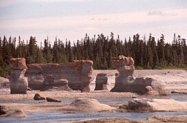
Important landmarks of Côte-Nord include Anticosti Island, the Mingan Archipelago National Park Reserve, and the Manicouagan Reservoir.
A territorial dispute between Quebec and Newfoundland and Labrador concerning the border between Côte-Nord and Labrador was set on 2 March 1927 by the Judicial Committee of the Privy Council. The boundary was entrenched in the Canadian constitution upon Newfoundland joining confederation in 1949. While this border has not been formally accepted by the Quebec government, the Henri Dorion Commission[8] (Commission d'étude sur l'intégrité du territoire du Québec) concluded in the early 1970s that Quebec no longer has a legal claim to Labrador.[9]
Protection of natural heritage
Several portions of territory on the Côte-Nord are dedicated specifically to the protection and maintenance of biological diversity. The region has 262 wildlife habitats, 172 aquatic bird concentration areas, 12 heronries, 66 bird colonies on islands, peninsulas or cliffs, 4 muskrat habitats and 8 white-tailed deer containment areas on Anticosti Island.[5]
Overwiew of the diversity
- Geographical heritage
-

-

-
-
 Sault Plat River, geological site
 -
 Anticosti Island UNESCO's World Heritage


- Biological heritage
-
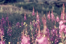 Epilobium angustifolium Linné. — Épilobe à feuilles étroites. — Bouquets rouges. — (Fireweed).
 -
 Spiranthes romanzoffiana Chamisso. – Spiranthe de Romanzoff. – (Romanzoff's ladies'-tresses).
 -
 Campanula rotundifolia Linné. – Campanule à feuilles rondes. – (Bluebell).
 -
 Ledum groenlandicum. — Lédon du Groenland. — Thé du Labrador, Thé velouté. — (Labrador Tea).
 -
 Rubus chamaemorus Linné. — Ronce petit-mûrier. — Mûres blanches, Blackbières, Plaquebières, Chicoutés. — (Cloudberry).


Fauna
The Côte-Nord has abundant and diversified wildlife resources spread throughout the territory.[5] Each year, the Fur Trapping Agency publishes an information bulletin on the furbearers of the North Shore. Among the main prey, they are considered common to abundant and generally stable.
- Lepus americanus. – Snowhoe hare. Lièvre d’Amérique
- Sciurus vulgaris. — Écureuil roux. — (Red squirrel).
- Mus musculus. — Souris grise. — (House mouse).
Species considered rare in the region.[10]
- Canis latrans. — Coyote. — (Coyote).
- Mephitis mephitis. — Mouffette rayée. — (Striped skunk).
- Pekania pennanti. — Pékan. — (Fisher).
- Procyon lotor. — Raton laveur. — (Raccoon).
- Lynx rufus. — Lynx roux. — (Bobcat)
Small game
Most well-known small game is and the Snowshoe hare and Grouses family species[11][12]
- Bonasa umbellus. — Gélinotte huppée. — (Ruffed grouse).
- Canachites canadensis. — Tétras du Canada. — (Spruce grouse).
- Lagopus lagopus. — Lagopède des saules. — (Willow Ptarmigan).
Mammals

The most well-known species are:
- Martes. — Martes. — (Weasel).
- Castor canadensis. — Castor du Canada. —North American Beaver.
- Ondatra zibethicus. — Rat musqué. — (Muskrat).
- Neovison vison. — Vison d'Amérique. — (Mink).
- Vulpes vulpes. — Renard commun. — (Fox).
- Canis lupus. — Loup. — (Wolf).
- Gulo gulo. — Glouton, Carcajou. — (Wolverine)
- Lynx canadensis. — Lynx du Canada. — (Canada lynx).[14][15]
The large fauna includes:
- Rangifer tarandus caribou. — Caribou des bois. — (Caribou).
- Alces americanus. — Orignal, élan. — (Moose).
- Odocoileus virginianus. — Cerf de Virginie, Chevreuil. — (White-tailed deer). Present only on Anticosti Island.
- Ursus americanus. — Ours noir. — (Black bear). Considered extinct on Anticosti Island.[5]
Avi-fauna
An important migratory stopover for birds, the Côte-Nord offers many favourite sites to observe 350 listed species at leisure.[16]

The diversity of habitats favours the presence of many avian species. According to the Manicouagan Ornithology Club, a wide variety of birds have been observed on the Côte-Nord including:
- Gavia stellata. — Plongeon catmarin. — (Red-throated loon).
- Sterna paradisaea. — Sterne arctique. — (Arctic tern).
- Fratercula arctica. — Le Macareux moine, Perroquet de mer ou Calculot. — (Atlantic puffin, Common puffin).
- Haliaeetus leucocephalus. Pygargue à tête blanche. — (Bald eagle). is a species at risk or designated threatened or vulnerable.[18]
From Tadoussac to Blanc-Sablon, along The Whale Route (Route 138), it is possible to observe marine mammals.
- Delphinapterus leucas. — Béluga, Bélouga, Baleine blanche, Marsouin. — (Beluga).
- Balaenoptera acutorostrata. — Petit rorqual. — (Minke whale).
- Balaenoptera physalus. — Rorqal commun. — (Fin whale).
- Phocoena phocoena. — Marsouin commun. — (Harbor Porpoise).
- Balaenoptera musculus. — Baleine bleue, Rorqual bleu. — (Blue whale).[19]
- Halichoerus grypus. — Phoque gris. — (Grey Seal).
- Phoca vitulina. — Phoque commun. — (Harbour Seal).
- Pagophilus groenlandicus. — Phoque du Groenland. — (Harp Seal).
Economy

The hydrography of the region has always been considered over the centuries as a structuring element, whether for exchanges between indigenous nations, for the beginning of colonization, for logging and transport of wood and, more recently, for the development of hydroelectricity and recreational tourism.[3][5]

The region's economy is based on mining (mostly iron), lumbering, aluminum production, and tourism. Côte-Nord's fourteen hydroelectric dams, notably the Manicouagan-Outardes complex, supply Hydro-Québec with over 10,500 megawatts of power.
Population
At the 2016 Canadian Census, the population amounted to 92,518, approximately 1.1% of the province's population,[2] spread across 33 municipalities, various Indian reserves and a Naskapi reserved land. The towns of Baie-Comeau and Sept-Îles combined amount to a little more than half of the population of the region.
Administrative divisions
Caniapiscau — La Haute-Côte-Nord — Le Golfe-du-Saint-Laurent — Manicouagan — Minganie — Sept-Rivières
Essipit — La Romaine — Lac-John — Maliotenam (part of Uashat-Maliotenam) — Matimekosh — Mingan — Nutashkuan — Pessamit — Uashat (part of Uashat-Maliotenam)
Naskapi reserved territory
Demographics
In the 2021 Census of Population conducted by Statistics Canada, the Côte-Nord region had a population of 88,525 living in 39,798 of its 45,263 total private dwellings, a change of -4.3% from its 2016 population of 92,518, making it the fastest-decreasing region of Québec. With a land area of 234,442.27 km2 (90,518.67 sq mi), it had a population density of 0.4/km2 (1.0/sq mi) in 2021.[20]
The median age is 46.4, as opposed to 41.6 for all of Canada. French was the mother tongue of 84.9% of residents in 2021. The next most common mother tongues were the Cree-Innu languages at 7.8% total, followed by English at 4.5%. 0.6% reported both English and French as their first language. Additionally, there were 0.8% who reported both French and a non-official language as their mother tongue, mostly speakers of Cree-Innu languages.
Speakers of Cree-Innu languages mostly live in Pessamit and Uashat-Maliotenam. English speakers mostly live in Le Golfe-du-Saint-Laurent Regional County Municipality.
As of 2021, Indigenous peoples comprised 16.2% of the population and visible minorities contributed 1.5%. The largest visible minority groups in Côte-Nord are Black (0.7%), Arab (0.2%), and Latin American (0.2%). The region is home to 280 recent immigrants (i.e. those arriving between 2016 and 2021). 130 of them come from various African countries.
In 2021, 71.3% of the population identified as Catholic, while 19.6% said they had no religious affiliation. Anglicans were the largest religious minority, at 1.9% of the population, while Muslims were the largest non-Christian religious minority, making up 0.4% of the population.
Major communities
Baie-Comeau — Fermont — Forestville — Havre-Saint-Pierre — Port-Cartier — Sept-Îles
Exploration
The Côte-Nord region was gradually explored by French colonists during the centuries with the help of natives. However it is worth noting the contribution of Henry de Puyjalon (1841-1905), a pioneer in ecology who devoted his life to the exploration of this region.
See also
- Quebec Route 138 (The Whale Route), from Tadoussac to Blanc-Sablon
- Rivière-au-Tonnerre, village-relais
- Maritime Quebec
References
Between nature and excess
- ^ a b "Côte-Nord". Quebec Gouvernement (in French). Commission de Toponymie Quebec. 1988-11-01. Retrieved 3 June 2024.
This vast territory includes the RCMs of Caniapiscau, La Haute-Côte-Nord, Manicouagan, Sept-Rivières, Minganie and the Gulf of St. Lawrence.
- ^ a b c "Census Profile, 2016 Census: Côte-Nord [Economic region], Quebec". Statistics Canada. 8 February 2017. Retrieved November 23, 2019.
- ^ a b c "Côte-Nord (région 09)". Administrative regions of Quebec (in French). Gouvernement of Quebec. 28 March 2024. Retrieved 5 July 2024.
Main cities : Sept-Îles, Baie-Comeau, Port-Cartier - Emerging economic sectors: mining, hydroelectricity, agri-food, tourism
- ^ "Administrative region 09: Côte-Nord, maps" (PDF). Quebec Gouvernement (in French). Ministry of Municipal Affairs and Housing Quebec. 27 February 2023. Retrieved 5 July 2024.
Maps and tables of the territories of the Regional County Municipalities (RCM) and their municipalities
- ^ a b c d e f Sonia Burgess; Linda Coulombe; Lucie Rousseau (28 February 2007). "Portrait territorial - Côte-Nord" (PDF). Direction régionale de la gestion du territoire public de la Côte-Nord. Ministry of Natural Resources and Wildlife. p. 94. Retrieved 3 June 2024.
Public land, knowledge, territorial portraits, lands and resources in the domain of the State
- ^ Pierre Frenette (2013). "The Gulf Historical Society" (in French). Retrieved 10 July 2024.
a legacy left by the meeting of several worlds, including that of the Laurentian peoples, that of the indigenous peoples of the interior and those of the different maritime peoples of the Gulf of St. Laurent
- ^ "The prehistory of Quebec". Archeo-Quebec (in French). The archeology dissemination network. 2024. Retrieved 10 July 2024.
Archaic Native Americans exploited all available animal and plant resources. They live a seasonal nomadism
- ^ Henry Dorion (7 December 2001). "Quebec's borders: the state of the question" (PDF) (in French). Commission to Study Questions Relating to Québec's Accession to the sovereignty. p. 27. Retrieved 3 June 2024.
the boundary will follow the watershed, the shoreline, a geodesic line, or that it will end at some topographical accident.
- ^ Arthur Krim, Boston Architectural College (2016–2024). "Urbanism and Iron Mining in Labrador". American Geographical Society. Focus on Geography. Retrieved 3 June 2024.
On the western edge of Labrador, along the Quebec border, in the taiga forests of the subarctic, lie the richest deposits of iron ore in North America.
- ^ North Shore Wildlife Management Department (2022). "In the eye of the lynx" (PDF). Furbearer Bulletin of the region (in French). Ministry of Forests, Wildlife and Parks Quebec. Retrieved 4 June 2024.
The marten is one of the most prized species by trappers, as it is relatively easy to capture because of its curiosity and, until recently, its fur was of good value.
- ^ Dr. W. Shufeldt (19 September 1881). "Osteology of the North American Tetraonidae" (PDF). Department of interior United States Geological and Geographical survey. Retrieved 8 July 2024.
No country in the world can boast of a fairer collection of species of these noble birds than we find among the six North American genera,
- ^ Laurence N. Ellison (2008). "Grouse: Wildlife Notebook Series" (PDF). Alaska Department of Fish and Game. Retrieved 8 July 2024.
Principal fall foods include blueberries, high bush cranberries, rose hips, and aspen buds
- ^ "The black bear in our forests" (PDF). Appalachian Corridor ACA (in French). 11 November 2003. Retrieved 9 July 2024.
It is frequently encountered at near streams, rivers or lakes as well as on the edge
- ^ "Area Furbearer Bulletin" (PDF). Ministry of Forests, Wildlife and Parks (in French). Dans l’œil du lynx. 2022. p. 6. Retrieved 3 June 2024.
Coyote, skunk, fisher, raccoon and bobcat are considered rare in the Côte-Nord region.
- ^ "In the eye of the lynx" (PDF).
- ^ "Ornithology". Quebec sea side (in French). Maritime Quebec. Retrieved 15 June 2024.
The regions of maritime Quebec are home to hundreds of species of birds, which you can observe in the natural environment.
- ^ Richards C; Padget O, Guilford T; Bates AE (31 October 1921). "Manx shearwater (Puffinus puffinus) rafting behaviour revealed by GPS tracking and behavioural observations". An official website of the United States government. National Library of Medicine. Retrieved 7 July 2024.
Before visiting or leaving their remote island colonies, seabirds often engage in a behaviour termed 'rafting', where birds sit, often in groups, on the water close to the colony.
- ^ Robert, Michel; Marie-Hélène Hachey; Denis Lepage; Andrew.R. Couturier (dir.) (2019). "Second Atlas of the Breeding Birds of Southern Québec". Canadian Wildlife Service (Environment and Climate Change Canada. p. 694.
The Atlas provides the most up-to-date information on the distribution and abundance of 253 species of birds that breed in Quebec below 50.5° north latitude
- ^ "Come see the whales". Côte-Nord, between nature and excess. North Shore Tourism. 2024. Retrieved 4 June 2024.
The tide, the underwater relief and the currents generate phenomenal concentrations of fish and plankton. No wonder the St. Lawrence is one of the best places in the world for whale watching: it's a real open-air buffet!
- ^ "Population and dwelling counts: Canada, provinces and territories, and census subdivisions (municipalities), Quebec". Statistics Canada. October 25, 2022. Retrieved December 13, 2022.
External links
- Reception and interpretation center Parks Canada, Havre-Saint-Pierre, Longue-Pointe-de-Mingan, Aguanish, Baie-Johan-Beetz
- Gabriel Sagard (1590-1640), The Long Journey to the Country of the Hurons, 529 p, (French)
- Quebec oiseaux, brings together Quebec's birdwatching clubs and societies, individual members and affiliated organizations
- Regional Portal
- Côte-Nord Tourism
| Regional county municipalities and equivalent territories | |
|---|---|
| Municipalities | |
| International | |
|---|---|
| National | |