Lesotho: Difference between revisions
No edit summary |
No edit summary |
||
| Line 1: | Line 1: | ||
<table border="1" cellpadding="2" cellspacing="0" align="right" style="margin-left:0.5em;" width="300px"> |
<table border="1" cellpadding="2" cellspacing="0" align="right" style="margin-left:0.5em;" width="300px"> |
||
<caption><font size="+1">'''Official Country Name(s) (local)'''</font></caption> |
<caption><font size="+1">'''Official Country Name(s) (local)'''</font></caption> |
||
| Line 11: | Line 9: | ||
</table></td></tr> |
</table></td></tr> |
||
<tr><td align="center" colspan=2 style="border-bottom:3px solid gray;"><font size="-1">''National [[motto]]: Xxxxx''</font></td></tr> |
<tr><td align="center" colspan=2 style="border-bottom:3px solid gray;"><font size="-1">''National [[motto]]: Xxxxx''</font></td></tr> |
||
<tr><td align=center colspan=2> |
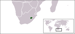
<tr><td align=center colspan=2>[[image:LocationLesotho.png]] |
||
</td></tr> |
|||
<tr><td>[[Official language]] </td><td>Xxxxx</td></tr> |
<tr><td>[[Official language]] </td><td>Xxxxx</td></tr> |
||
<tr><td>[[Capital]] </td><td>Xxxxx</td></tr> |
<tr><td>[[Capital]] </td><td>Xxxxx</td></tr> |
||
Revision as of 17:49, 28 February 2004
| |||||
| National motto: Xxxxx | |||||

| |||||
| Official language | Xxxxx | ||||
| Capital | Xxxxx | ||||
| (optionally) Capital's coordinates | X° X' N/S, X° X' E/W | ||||
| (optionally) Largest City | Xxxxx | ||||
| monarch/president | Xxxxx | ||||
| Area - Total - % water | Ranked xth xx,xxx km² xx% / Negligible | ||||
| Population
- Density | Ranked xth
xxx/km² | ||||
| GDP (PPP)
- GDP/head | Ranked xth
xx,xxx $ | ||||
| Currency | Xxxxx | ||||
| Time zone | UTC +/-X (DST, yes or not) | ||||
| Independence
- Recognised | (Event Xxxx)
(Year) | ||||
| National anthem | Xxxxx | ||||
| Internet TLD | .XX | ||||
| Calling Code | XX | ||||
Basutoland was renamed the Kingdom of Lesotho upon independence from the United Kingdom on October 4 1966. Constitutional government was restored in 1993 after 23 years of authoritanism, which include seven years of military rule.
Small, landlocked, and mountainous, Lesotho's only important natural resource is water. Its economy is based on subsistence agriculture, livestock, and remittances from miners employed in South Africa. The number of such mine workers has declined steadily over the past several years. In 1996 their remittances added about 33% to GDP compared with the addition of roughly 67% in 1990. A small manufacturing base depends largely on farm products which support the milling, canning, leather, and jute industries. Agricultural products are exported primarily to South Africa. Proceeds from membership in a common customs union with South Africa form the majority of government revenue. Although drought has decreased agricultural activity over the past few years, completion of a major hydropower facility in January 1998 now permits the sale of water to South Africa, generating royalties that will be an important source of income for Lesotho. The pace of parastatal privatization has increased in recent years. Civil disorder in September 1998 destroyed 80% of the commercial infrastructure in Maseru and two other major towns. Most firms were not covered by insurance, and the rebuilding of small and medium business has been a significant challenge in terms of both economic growth and employment levels. Output dropped 10% in 1998 and recovered slowly in 1999.
Districts
Main Article: Districts of Lesotho
Lesotho is divided into 10 districts: Berea, Butha-Buthe, Leribe, Mafeteng, Maseru, Mohale's Hoek, Mokhotlong, Qacha's Nek, Quthing, and Thaba-Tseka.
- History of Lesotho
- Geography of Lesotho
- Demographics of Lesotho
- Politics of Lesotho
- Economy of Lesotho
- Communications in Lesotho
- Transportation in Lesotho
- Military of Lesotho
- Foreign relations of Lesotho
- Culture of Lesotho (Music of Lesotho)
Originally from the CIA World Factbook 2000 and the U.S. Department of State website.
