Buttonwillow, California: Difference between revisions
m general fixes using AWB |
Michael93555 (talk | contribs) |
||
| Line 70: | Line 70: | ||
The first post office at Buttonwillow in 1895.<ref name=CGN /> |
The first post office at Buttonwillow in 1895.<ref name=CGN /> |
||
Buttonwillow is a major stop for motorists travelling on [[Interstate 5 (California)|Interstate 5]]. It includes a number of gas stations including ([[Exxon]], [[Shell Oil Company|Shell]], [[Chevron Corporation|Chevron]], and [[ARCO|Arco]]), a [[McDonald's]], a [[Carl's Jr.]], a drive through Starbuck's, Willow Ranch BBQ |
Buttonwillow is a major stop for motorists travelling on [[Interstate 5 (California)|Interstate 5]]. It includes a number of gas stations including ([[Exxon]], [[Shell Oil Company|Shell]], [[Chevron Corporation|Chevron]], and [[ARCO|Arco]]), a [[McDonald's]], a [[Carl's Jr.]], a drive through Starbuck's, Willow Ranch BBQ restaurant, an Indian restaurant, a Mexican-Salvadoran restaurant, [[TravelCenters of America]], and Castro Tire & Truckwash. These are all located at the exit of [[California State Route 58|State Route 58]]. There is a large electrical [[substation]] next to the town that is a part of a major North-South transmission corridor. It marks the northern end of [[Path 26]] across the [[Transverse Ranges]] and the southern end of the [[Path 15]] [[electric power transmission|power line]]s. Buttonwillow is also the motel hub for member of the [[Sports Car Club of America]]'s Cal Club region when they hold events at Cal Club-owned [[Buttonwillow Raceway Park]] - a [[Super 8 Motels|Super 8]], a [[Motel 6]] and the Homeland Inn are the motels of note there. |
||
==Geography== |
==Geography== |
||
Revision as of 19:26, 25 June 2009
Buttonwillow, California | |
|---|---|
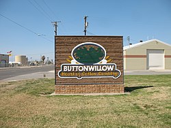
 the entrance to the city | |
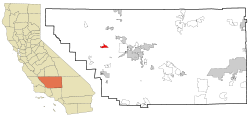
 Location in Kern County and the state of California | |
| Land | Vereinigte Staaten |
| State | California |
| County | Kern |
| Regierung | |
| • Senate | Dean Florez (D) |
| • Assembly | Nicole Parra (D) |
| • U. S. Congress | Jim Costa (D) |
| Area | |
| • Total | 7 sq mi (18 km2) |
| • Land | 7 sq mi (18 km2) |
| • Water | 0 sq mi (0 km2) |
| Elevation | 269 ft (82 m) |
| Population (2000) | |
| • Total | 1,266 |
| • Density | 180.9/sq mi (70.3/km2) |
| Time zone | UTC-8 (PST) |
| • Summer (DST) | UTC-7 (PDT) |
| ZIP code | 93206 |
| Area code | 661 |
| FIPS code | 06-09332 |
| GNIS feature ID | 1652678 |
Buttonwillow (formerly, Buena Vista)[2] is a census-designated place (CDP) in Kern County, California, United States. Buttonwilliow is located 26 miles (42 km) west of Bakersfield,[2] at an elevation of 269 feet (82 m).[1] The population was 1,266 at the 2000 census. The center of population of California is located in Buttonwillow [1].
History
The town was originally called Buena Vista when it was laid out in 1895, but the name quickly became Buttonwillow.[2]
Buttonwillow was named for the buttonbush (Rubiaceae cephalanthus occidentalis), which resembles the willow. A lone button bush served as a landmark on an old trans-valley trail, and was used by ancient Yokut Indian as a meeting place, later becoming the site of settlers' stock rodeos. This tree is listed as California Historical Landmark No. 492. This landmark is now known as the Buttonwillow Tree.
The first post office at Buttonwillow in 1895.[2]
Buttonwillow is a major stop for motorists travelling on Interstate 5. It includes a number of gas stations including (Exxon, Shell, Chevron, and Arco), a McDonald's, a Carl's Jr., a drive through Starbuck's, Willow Ranch BBQ restaurant, an Indian restaurant, a Mexican-Salvadoran restaurant, TravelCenters of America, and Castro Tire & Truckwash. These are all located at the exit of State Route 58. There is a large electrical substation next to the town that is a part of a major North-South transmission corridor. It marks the northern end of Path 26 across the Transverse Ranges and the southern end of the Path 15 power lines. Buttonwillow is also the motel hub for member of the Sports Car Club of America's Cal Club region when they hold events at Cal Club-owned Buttonwillow Raceway Park - a Super 8, a Motel 6 and the Homeland Inn are the motels of note there.
Geography
Buttonwillow is located at 35°24′02″N 119°28′10″W / 35.40056°N 119.46944°WInvalid arguments have been passed to the {{#coordinates:}} function.[1]
According to the United States Census Bureau, the CDP has a total area of 7.0 square miles (18.1 km²), all of it land. Buttonwillow is also locally known as the cotton country, due to the abundant planting of cotton in the vicinity.
Beginning about four miles (6 km) south of town along Elk Hills Road, between Buttonwillow and Taft, is the enormous Elk Hills Oil Field, formerly the Naval Petroleum Reserve No. 1, which figured prominently in the Teapot Dome scandal that tarnished the administration of President Warren G. Harding. Occidental Petroleum bought the reserve from the U.S. Department of Energy in 1998, and is the current primary operator of the oil field.
Demographics
As of the censusTemplate:GR of 2000, there were 1,266 people, 328 households, and 270 families residing in the CDP. The population density was 181.7 people per square mile (70.1/km²). There were 364 housing units at an average density of 52.2/sq mi (20.2/km²). The racial makeup of the CDP was 34.28% White, 3.79% Black or African American, 1.66% Native American, 0.08% Asian, 55.06% from other races, and 5.13% from two or more races. 68.40% of the population were Hispanic or Latino of any race.
There were 328 households out of which 56.4% had children under the age of 18 living with them, 61.6% were married couples living together, 14.3% had a female householder with no husband present, and 17.4% were non-families. 15.2% of all households were made up of individuals and 7.9% had someone living alone who was 65 years of age or older. The average household size was 3.81 and the average family size was 4.25.
In the CDP the population was spread out with 38.0% under the age of 18, 12.6% from 18 to 24, 27.6% from 25 to 44, 13.4% from 45 to 64, and 8.3% who were 65 years of age or older. The median age was 24 years. For every 100 females there were 107.2 males. For every 100 females age 18 and over, there were 106.6 males.
The median income for a household in the CDP was $28,370, and the median income for a family was $29,716. Males had a median income of $19,514 versus $16,974 for females. The per capita income for the CDP was $9,424. About 23.1% of families and 28.7% of the population were below the poverty line, including 35.4% of those under age 18 and 11.8% of those age 65 or over.
References
- ^ a b c U.S. Geological Survey Geographic Names Information System: Buttonwillow, California
- ^ a b c d Durham, David L. (1998). California's Geographic Names: A Gazetteer of Historic and Modern Names of the State. Clovis, Calif.: Word Dancer Press. p. 1009. ISBN 1-884995-14-4.
Photos of the area
-
Tule Elk at the state reserve.
-
The control tower at Buttonwillow Raceway Park.


