
Steel Bridge: Difference between revisions
No edit summary |
→History: Added more history, removed redundant "currently" |
||
| Line 43: | Line 43: | ||
| pages = 208 |
| pages = 208 |
||
| isbn = 0-87595-205-4 |
| isbn = 0-87595-205-4 |
||
}}</ref> It opened in July 1912 to rail traffic and on August 9, 1912 to automobiles. |
}}</ref> It opened in July 1912 to rail traffic and on August 9, 1912 to automobiles. In 1950, the Steel Bridge became an important part of a new [[U.S. 99|U.S. 99W]] freeway, the first freeway in Portland, between [[Harbor Drive]] and Interstate Avenue. The Harbor Drive freeway was removed in 1974 and replaced with [[Tom McCall Waterfront Park]]. |
||
In 2001, a 220 ft (67 m) long and 8 ft (2.5 m) wide cantilevered walkway was installed on the southern side of the bridge's lower deck as part of the [[Eastbank Esplanade]] construction, making a total of three publicly accessible walkways, including two narrow sidewalks on the upper deck. The bridge is |
Between 1984 and 1986 the bridge underwent a $10 million rehabilitation including construction of the MAX light rail line replacing one of the motor vehicle lanes. |
||
In 2001, a 220 ft (67 m) long and 8 ft (2.5 m) wide cantilevered walkway was installed on the southern side of the bridge's lower deck as part of the [[Eastbank Esplanade]] construction, making a total of three publicly accessible walkways, including two narrow sidewalks on the upper deck. The bridge is owned by Union Pacific with the upper deck leased to [[Oregon Department of Transportation]], and subleased to [[TriMet]], with the City of Portland is responsible for the approaches.<ref>{{cite news |
|||
| last = Redden |
| last = Redden |
||
| first = Jim |
| first = Jim |
||
Revision as of 02:15, 4 April 2010
Steel Bridge | |
|---|---|
 | |
| Coordinates | 45°31′40″N 122°40′05″W / 45.5278°N 122.668°W |
| Carries | Upper: 2 outer traffic lanes and two inner lanes solely for MAX Light Rail Lower: Union Pacific Railroad (incl. Amtrak toward Eugene) and walkway |
| Crosses | Willamette River |
| Locale | Portland, Oregon |
| Maintained by | Union Pacific Railroad |
| Characteristics | |
| Design | Through truss with a double vertical lift span |
| Width | 71 ft (22 m) |
| Longest span | 211 ft (64 m) |
| Clearance below | 26 ft (8 m) closed, 72 ft (22 m) lower deck raised, 163 ft (50 m) fully raised |
| History | |
| Opened | 1912 (replaced 1888 bridge) |
| Standort | |
 | |
The Steel Bridge is a through truss, double lift bridge across the Willamette River in Portland, Oregon, United States. Its lower deck carries railroad and bicycle/pedestrian traffic, while the upper deck carries road traffic (on the Pacific Highway West No. 1W, former Oregon Route 99W) and light rail (MAX), making the bridge one of the most multimodal in the world. It is the only double-deck bridge with independent lifts in the world[1] and the second oldest vertical lift bridge in North America, after the nearby Hawthorne Bridge. The bridge links the Rose Quarter and Lloyd District in the east to Old Town Chinatown neighborhood in the west.
History
The bridge was completed in 1912 and replaced the Steel Bridge that was built in 1888 as a double-deck swing span bridge (photo). The 1888 structure was the first railroad bridge across the Willamette River in Portland. Its name originated because steel, instead of wrought iron, was used in its construction, very unusual for the time.[2] When the current Steel Bridge opened, it was simply given its predecessor's name.
The structure was built by Union Pacific Railroad and the Oregon Railway and Navigation Company at a cost of $1.7 million.[3] It opened in July 1912 to rail traffic and on August 9, 1912 to automobiles. In 1950, the Steel Bridge became an important part of a new U.S. 99W freeway, the first freeway in Portland, between Harbor Drive and Interstate Avenue. The Harbor Drive freeway was removed in 1974 and replaced with Tom McCall Waterfront Park.
Between 1984 and 1986 the bridge underwent a $10 million rehabilitation including construction of the MAX light rail line replacing one of the motor vehicle lanes.
In 2001, a 220 ft (67 m) long and 8 ft (2.5 m) wide cantilevered walkway was installed on the southern side of the bridge's lower deck as part of the Eastbank Esplanade construction, making a total of three publicly accessible walkways, including two narrow sidewalks on the upper deck. The bridge is owned by Union Pacific with the upper deck leased to Oregon Department of Transportation, and subleased to TriMet, with the City of Portland is responsible for the approaches.[4]
The upper deck was closed again for summer 2008 for maintenance and to allow a junction to be built at the west end for the MAX Green Line. The lower deck of the bridge was threatened by major floods in 1948, 1964, and 1996.
Structure

The lift span of the bridge is 211 ft (64 m) long. At low river levels the lower deck is 26 ft (7.9 m) above the water, and 163 ft (50 m) of vertical clearance is provided when both are raised. Because of the independent lifts, the lower deck can be raised to 72 ft (22 m), telescoping into the upper deck but not disturbing it. Each deck has it own counterweights, two for the upper and eight for the lower, totaling 9,000,000 lb (4,100 metric tons).
The machinery house is above the upper-deck lift span with an operator's room suspended below the house so that the operator can view river traffic as well as the upper deck. The average daily traffic in 2000 was 23,100 vehicles (including many TriMet bus lines), 200 MAX trains, 40 freight and Amtrak trains, and 500 bicycles. The construction of the lower-deck walkway connected to the Eastbank Esplanade resulted in a sharp increase in bicycle traffic, with over 2,100 daily bicycle crossings in 2005.[5]
Gallery
-
 HAER description
 -
 Diagram of lifting mechanism
 -
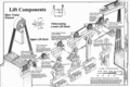 Diagram of lift components
 -
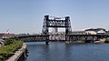 The bridge while fully open


See also
There are five other known Waddell & Harrington vertical-lift railroad bridges in Oregon.[6] These are:
- Burlington Northern Railroad Bridge 5.1, crosses the Willamette in Portland
- Oregon Trunk Rail Bridge (Celilo Bridge), crosses the Columbia River near The Dalles
- Union Street Railroad Bridge crosses the Willamette in Salem
- Two unnamed bridges, cross the Willamette between Harrisburg and Junction City at river mile 162.7 and 162.8
References
- ^ "Willamette River (Steel) Bridge" (DOC). Portland Bridges. Oregon Department of Transportation. 1999. Retrieved 2007-08-25.
- ^ Wood, Sharon (2001). The Portland Bridge Book (2nd Edition). Oregon Historical Society. ISBN 0-87595-211-9.
- ^ Smith, Dwight A. (1989). Historic Highway Bridges of Oregon. Oregon Historical Society Press. p. 208. ISBN 0-87595-205-4.
{{cite book}}: Unknown parameter|coauthors=ignored (|author=suggested) (help) - ^ Redden, Jim (October 19, 2006). "Steel Bridge is less than solid". Portland Tribune. Retrieved 2006-11-06.
- ^ "Bridge bike traffic up in '05". BikePortland.org. Retrieved 2006-04-09.
- ^ "National Register of Historic Places Registration Form: Union Street Railroad Bridge and Trestle" (PDF). City of Salem. Retrieved February 1, 2009.