
Sevan, Armenia: Difference between revisions
Kevorkmail (talk | contribs) No edit summary |
No edit summary |
||
| Line 31: | Line 31: | ||
|website = |
|website = |
||
}} |
}} |
||
'''Sevan''' ( |
'''Sevan''' ({{lang-hy|Սևան}}; also '''Ssewan'''; until 1935, '''Elenovka''' or '''Yelenovka''') is a city in [[Armenia]], in the [[Gegharkunik Province]], lies on the northern shores of [[Lake Sevan]]. The town is 66 kilometers north-east of the capital [[Yerevan]], and 40 kilometers north of [[Gavar]], the administrative centre of Gegharkunik region. It was founded in 1842 as the Russian village Yelenovka and was known under this name until 1935. Sevan is surrounded by the Sevan National Park which is extended from the north-eastern side of the city to the south-west, while the Lake Sevan forms the natural borders of the town from the east. |
||
==History== |
==History== |
||
The town was founded as |
The town was founded as Yelenovka in 1842 by exiled Russian schismatics. Since its foundation until 1935, the town of Sevan was known as Yelenovka, named after the wife of [[Nicholas I of Russia|Czar Nicholas I]], and was. The town remained all Russian until the end of the 19th century. Only 1 kilometer north of the town, the cyclopean fortress of "Metsep" stands. On a hill just south of the village of Tsamakaberd, to the east of Sevan's centre, a cyclopean fortress is found. |
||
The Sevan peninsula, which is located 3 km east of the town is home to one of the most notable samples of medieval [[Armenian architecture]], |
The Sevan peninsula, which is located 3 km east of the town is home to one of the most notable samples of medieval [[Armenian architecture]], |
||
==Population== |
==Population== |
||
Revision as of 19:31, 6 May 2010
40°33′18″N 44°57′13″E / 40.55500°N 44.95361°E
Sevan Սևան | |
|---|---|
 The town of Sevan as seen from the road. | |
| Land | Armenien |
| Marz (Province) | Gegharkunik |
| Gegründet | 1842 |
| Regierung | |
| • Mayor | Gevorg Malkhasyan |
| Area | |
| • Total | 16 km2 (6 sq mi) |
| Population (2008) | |
| • Total | 21,700 |
| Time zone | UTC+4 ( ) |
| • Summer (DST) | UTC+5 ( ) |
Sevan (Armenian: Սևան; also Ssewan; until 1935, Elenovka or Yelenovka) is a city in Armenia, in the Gegharkunik Province, lies on the northern shores of Lake Sevan. The town is 66 kilometers north-east of the capital Yerevan, and 40 kilometers north of Gavar, the administrative centre of Gegharkunik region. It was founded in 1842 as the Russian village Yelenovka and was known under this name until 1935. Sevan is surrounded by the Sevan National Park which is extended from the north-eastern side of the city to the south-west, while the Lake Sevan forms the natural borders of the town from the east.
History
The town was founded as Yelenovka in 1842 by exiled Russian schismatics. Since its foundation until 1935, the town of Sevan was known as Yelenovka, named after the wife of Czar Nicholas I, and was. The town remained all Russian until the end of the 19th century. Only 1 kilometer north of the town, the cyclopean fortress of "Metsep" stands. On a hill just south of the village of Tsamakaberd, to the east of Sevan's centre, a cyclopean fortress is found.
The Sevan peninsula, which is located 3 km east of the town is home to one of the most notable samples of medieval Armenian architecture,
Population

The official census of 2001 showed a decline in the population of Sevan, which went down from 27,000 as was reported in the 1989 census to 21,422. Nowadays the population is around 22,000, most of which are engaged to agricultural activities, fish-hunting and some touristic services, especially during the summer season.
The village of Gagarin with its 1,500 dwellers, is also considered a part of the Sevan community, although being formed as a separate village, thus making the population of all the community around 23,500 (2009).
The community of Sevan has 8 public education schools whith one of them operating in the village of Gagarin. As of 2008, there were 4 nursery schools in Sevan and 1 in Gagarin.
Sister cities
 Bussy-Saint-Georges, since 7 August 2009[1]
Sport
Sevan is home to soccer club Akhtamar Sevan. During the brief summer Sevan is a popular beach resort. Many professionals and amateurs visit the city to practice their favourite types of sports on the shores, such as beach vollyball, wind-surfing and other types of water sports.
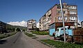
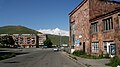
Gallery
-
 The town of Sevan.
 -
 The main road through Sevan
 -
 The town square
 -
 Sevan suburbs


References
- Sevan, Armenia at GEOnet Names Server
- World Gazeteer: Armenia – World-Gazetteer.com
- Report of the results of the 2001 Armenian Census, Statistical Committee of Armenia
- Kiesling, Brady (June 2000). Rediscovering Armenia: An Archaeological/Touristic Gazetteer and Map Set for the Historical Monuments of Armenia (PDF). Archived (PDF) from the original on 6 November 2021.
