Meijel: Difference between revisions
Appearance
Content deleted Content added
m Robot - Moving category Cities, towns and villages in Dutch Limburg to Populated places in Dutch Limburg per CFD at Wikipedia:Categories for discussion/Log/2010 May 28. |
m Bot) Add coordinates_region parameter (report errors? |
||
| Line 1: | Line 1: | ||
{{Infobox |
{{Infobox settlement |
||
|official_name = Meijel |
|official_name = Meijel |
||
| native_name = ''Mael'' |
| native_name = ''Mael'' |
||
| Line 13: | Line 13: | ||
|latd=51|latm=21|lats=|latNS=N |
|latd=51|latm=21|lats=|latNS=N |
||
|longd=5|longm=53|longs=|longEW=E |
|longd=5|longm=53|longs=|longEW=E |
||
|coordinates_region = NL |
|||
|subdivision_type = Country |
|subdivision_type = Country |
||
|subdivision_name = [[Netherlands]] |
|subdivision_name = [[Netherlands]] |
||
Revision as of 17:04, 10 June 2010
Meijel
Mael | |
|---|---|
City | |
 | |
| Land | Niederlande |
| Province | Limburg |
| Municipality | Peel en Maas |
| Time zone | UTC+1 (CET) |
| • Summer (DST) | UTC+2 (CEST) |
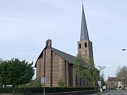
Meijel () (Limburgish: Mael) is a former municipality and a town in southeastern Netherlands.
External links
51°21′N 5°53′E / 51.350°N 5.883°E


