Échallens: Difference between revisions
m robot Adding: lmo:Echallens |
m robot Adding: war:Echallens |
||
| Line 101: | Line 101: | ||
[[rm:Echallens]] |
[[rm:Echallens]] |
||
[[vo:Echallens]] |
[[vo:Echallens]] |
||
[[war:Echallens]] |
|||
Revision as of 22:26, 9 July 2010
Echallens | |
|---|---|
| Land | Schweiz |
| Canton | Vaud |
| District | Echallens |
| Area | |
| • Total | 6.66 km2 (2.57 sq mi) |
| Elevation | 617 m (2,024 ft) |
| Population (31 December 2018)[2] | |
| • Total | 5,740 |
| • Density | 860/km2 (2,200/sq mi) |
| Time zone | UTC+01:00 (Central European Time) |
| • Summer (DST) | UTC+02:00 (Central European Summer Time) |
| Postal code(s) | 1040 |
| SFOS number | 5518 |
| ISO 3166 code | CH-VD |
| Surrounded by | Villars-le-Terroir, Poliez-le-Grand, Bottens, Malapalud, Assens, Saint-Barthélemy, Goumoens-la-Ville. |
| Website | www Profil (in French), SFSO statistics |

Echallens is a municipality in the district of Echallens in the canton of Vaud in Switzerland.
Geography
Echallens lies at an elevation of 617 m. 14 km north of Lausanne. The municipality stretches across the Gros de Vaud plateau, on both sides of the river Talent, on the northwest edge of the Jorat, in central Vaud.
It includes a section of the rolling Gros de Vaud, the breadbasket of the canton of Vaud. The Talent runs from east to west across the municipality, from the highlands of the Jorat. In the southwest, it runs down to the Mortigue (a tributary of the Talent). The highest point in the municipality is at an elevation of 672 m. in the municipality woods. In 1997, 18 percent of municipality land was residential, 13 percent woods, 68 percent agricultural, and a little less than 1 percent unproductive land.
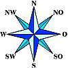
Echallens lies in the middle of its district. The surrounding minicipalities are Villars-le-Terroir, Poliez-le-Grand, Bottens, Malapalud, Assens, Saint-Barthélemy, and Goumoens-la-Ville, all in the same district.
| Goumoens-la-Ville | Villars-le-Terroir | Villars-le-Terroir |
| Saint-Barthélemy | 
|
Poliez-le-Grand |
| Assens | Malapalud | Bottens |
History
The territory of the municipality was already settled very early. There are remains of a Bronze Age foundry.
The first documentation dates from 1141 under the name of Charlens. Later forms of the name include Challeins, Escharlens (1177), Eschallens (1228), and Eschalleins (1279). The present form of the name first appears in 1315. The name comes from the personal name Charles.
The site belonged originally to the Bishop of Lausanne. At the end of the 12th century, the Burgundian Lords of Montfaucon established the territory of Echallens and built a castle there in the 13th century. In 1317, the rights of the house of Savoy were recognized. In 1350, Echallens was encircled by a wall and received city rights in 1351. From then until the 16th century, a weekly market was held.
In 1410, the government of Echallens passed to the house of Chalon, which originated in Burgundy. For this reason, the Eidgenossen took over after the Burgundian Wars and put it under the administration of Fribourg and Bern in 1476.
Because of the common administration of Catholic Fribourg and Protestant Bern, the Reformation did not gain ground in Echallen, and it remained Catholic.
Echallens belonged from 1798 to 1803 to the canton of Léman in the Helvetic Republic, and was brought into the canton of Vaud by the mediation of Napoleon. It has been the capital of the district since 1798.
Population
With 4843 inhabitants (as of 2005), Echallens is one of the middle-sized towns of the canton of Vaud. The population is 89.1 percent French-speaking, 2.9 percent German-speaking, and 2.1 percent Portuguese-speaking (as of 2000). The population has grown from 956 in 1850 to and 1095 in 1900.
Economy
Echallens is a regionally important commercial center of the Gros de Vaud. Until the end of the 19th century, it was primarily agricultural. Today, agriculture is quite marginal.
The municipality became slowly industrialized, with machining, metalworking, and textiles being the major industries.
Most jobs (almost 70 percent) are in the service sector. Many people now commute to Lausanne.
Sport
FC Echallens play in the town. The team currently plays in Liga 1., the third highest tier in the Swiss football pyramid. Their home stadium is Sportplatz 3 Sapins which is situated on the outskirts of Echallens.
Transport
Echallens lies on the main highway between Lausanne and Yverdon-les-Bains. The entrance to the A1 motorway at La Sarraz opened in 1981 and is only about 7 km from the center.
In 1874, the railway from Cheseaux-sur-Lausanne to Echallens opened a small-gauge line Lausanne-Echallens-Bercher (LEB). There are bus lines to Chavornay, Yverdon, und Thierrens.
References
- ^ a b "Arealstatistik Standard - Gemeinden nach 4 Hauptbereichen". Federal Statistical Office. Retrieved 13 January 2019.
- ^ "Ständige Wohnbevölkerung nach Staatsangehörigkeitskategorie Geschlecht und Gemeinde; Provisorische Jahresergebnisse; 2018". Federal Statistical Office. 9 April 2019. Retrieved 11 April 2019.

