Bladensburg National Park: Difference between revisions
Shiftchange (talk | contribs) add landscape features, homestead, info centre, dinosaur fossils, aborigine sites and massacre, camping, refs |
Shiftchange (talk | contribs) remove {{Queensland-national-park-stub}}, add sections, more features, birds, access, ref |
||
| Line 15: | Line 15: | ||
| official_site = [http://www.derm.qld.gov.au/parks/bladensburg/index.html Bladensburg National Park] |
| official_site = [http://www.derm.qld.gov.au/parks/bladensburg/index.html Bladensburg National Park] |
||
}} |
}} |
||
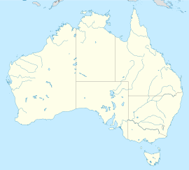
'''Bladensburg''' is a national park in [[Queensland]], [[Australia]], located 1152 km northwest of [[Brisbane]], and just south of the town of [[Winton, Queensland|Winton]]. |
'''Bladensburg''' is a national park in [[Queensland]], [[Australia]], located 1152 km northwest of [[Brisbane]], and just south of the town of [[Winton, Queensland|Winton]]. The 84,900 hectares of national park were declared in 1984. |
||
Birds common to the area include the [[Painted Firetail]], [[Rufous-crowned Emu-wren]] and [[Rufous-throated Honeyeater]].<ref name="naq"/> |
|||
==Landforms== |
|||
The park features grassland plains, river flats, sandstone ranges and flat-topped mesas.<ref name="qh">{{cite web |url=http://www.queenslandholidays.com.au/things-to-see-and-do/bladensburg-national-park/index.cfm |title=Bladensburg National Park |publisher=Tourism Queensland |accessdate=31 October 2010}}</ref> The main watercourse in the park is the often dry Surprise Creek.<ref name="naq"/> During floods the creek becomes a [[Braided river|braided channel]]. |
|||
The landscape to the south of the park has dissected tablelands with [[mesa]]s and [[butte]]s and to the far south are flat sand plains.<ref name="naq">{{cite book |title=Natural Areas of Queensland |last=Shilton |first=Peter |year=2005 |publisher=Goldpress |location=Mount Gravatt, Queensland |isbn=0-9758275-0-2 |pages=288-290 |accessdate=7 July 2011}}</ref> |
|||
==History== |
|||
Bladensburg was once a station, now a protected area containing [[mulga lands]] of high biodiversity. It covers both the [[Channel Country]] and Mulga Grass Downs bioregions. The original Bladensburg homestead, which was probably transported to the site some time in the 1910s, houses the park's visitor information centre today.<ref name="herqldout"/> |
Bladensburg was once a station, now a protected area containing [[mulga lands]] of high biodiversity. It covers both the [[Channel Country]] and Mulga Grass Downs bioregions. The original Bladensburg homestead, which was probably transported to the site some time in the 1910s, houses the park's visitor information centre today.<ref name="herqldout"/> |
||
The park contains [[dinosaur]] [[fossil]]s as well as aboriginal story places and ceremonial grounds.<ref name="herqldout">{{Cite book |title=Heritage Trails of the Queensland Outback |last=[[Environmental Protection Agency (Queensland)]] |year=2002 |publisher=State of Queensland |isbn=0-7345-1040-3 |pages=75 }}</ref> Skull Hole, a waterhole in the park was the site of an aboriginal massacre known as the Bladensburg Massacre.<ref name="herqldout"/> |
The park contains [[dinosaur]] [[fossil]]s as well as aboriginal story places and ceremonial grounds.<ref name="herqldout">{{Cite book |title=Heritage Trails of the Queensland Outback |last=[[Environmental Protection Agency (Queensland)]] |year=2002 |publisher=State of Queensland |isbn=0-7345-1040-3 |pages=75 }}</ref> Skull Hole, a waterhole in the park was the site of an aboriginal massacre known as the Bladensburg Massacre.<ref name="herqldout"/> |
||
==Facilities== |
|||
Camping is permitted beside Surprise Creek.<ref name="qh"/> |
|||
Access to the park is by 16 km of road from [[Winton, Queensland|Winton]].<ref name="naq"/> Camping is permitted beside Surprise Creek.<ref name="qh"/> No water is available.<ref name="naq"/> |
|||
==See also== |
==See also== |
||
| Line 33: | Line 42: | ||
[[Category:Protected areas established in 1984]] |
[[Category:Protected areas established in 1984]] |
||
{{Queensland-national-park-stub}} |
|||
[[es:Parque Nacional Bladensburg]] |
[[es:Parque Nacional Bladensburg]] |
||
Revision as of 07:51, 7 July 2011
| Bladensburg National Park Error: |state= not defined (help) | |
|---|---|
| Coordinates | 22°30′12″S 142°59′17″E / 22.50333°S 142.98806°E |
| Established | 1984 |
| Area | 849 km2 (328 sq mi) |
Error: |type= not defined (help) | |
Bladensburg is a national park in Queensland, Australia, located 1152 km northwest of Brisbane, and just south of the town of Winton. The 84,900 hectares of national park were declared in 1984.
Birds common to the area include the Painted Firetail, Rufous-crowned Emu-wren and Rufous-throated Honeyeater.[1]
Landforms
The park features grassland plains, river flats, sandstone ranges and flat-topped mesas.[2] The main watercourse in the park is the often dry Surprise Creek.[1] During floods the creek becomes a braided channel.
The landscape to the south of the park has dissected tablelands with mesas and buttes and to the far south are flat sand plains.[1]
History
Bladensburg was once a station, now a protected area containing mulga lands of high biodiversity. It covers both the Channel Country and Mulga Grass Downs bioregions. The original Bladensburg homestead, which was probably transported to the site some time in the 1910s, houses the park's visitor information centre today.[3]
The park contains dinosaur fossils as well as aboriginal story places and ceremonial grounds.[3] Skull Hole, a waterhole in the park was the site of an aboriginal massacre known as the Bladensburg Massacre.[3]
Facilities
Access to the park is by 16 km of road from Winton.[1] Camping is permitted beside Surprise Creek.[2] No water is available.[1]
See also
References
- ^ a b c d e Shilton, Peter (2005). Natural Areas of Queensland. Mount Gravatt, Queensland: Goldpress. pp. 288–290. ISBN 0-9758275-0-2.
{{cite book}}:|access-date=requires|url=(help) - ^ a b "Bladensburg National Park". Tourism Queensland. Retrieved 31 October 2010.
- ^ a b c Environmental Protection Agency (Queensland) (2002). Heritage Trails of the Queensland Outback. State of Queensland. p. 75. ISBN 0-7345-1040-3.

