Kartasura: Difference between revisions
mNo edit summary |
|||
| Line 23: | Line 23: | ||
[[Category:Subdistricts of Indonesia]] |
[[Category:Subdistricts of Indonesia]] |
||
[[es:Kartasura]] |
|||
[[fr:Kartasura]] |
[[fr:Kartasura]] |
||
[[id:Kartasura, Sukoharjo]] |
[[id:Kartasura, Sukoharjo]] |
||
Revision as of 09:27, 9 October 2011
Kartosuro (also spelled Kartasura) is an Indonesian subdistrict (Kecamatan) in the Sukoharjo Regency, Central Java. Kartosuro is a Surakarta's satellite city, and a junction of Surabaya-Solo-Yogyakarta and Solo-Semarang highway. It can be reached within minutes southward of Surakarta's International Airport of Adi Sumarmo.
History
In the seventeenth century Kartosuro was the capital of the Sultanate of Mataram between 1680-1755. It is commonly referred to as the Kartasura era or period of the Mataram sultanate - it preceded the transfer to Surakarta by Pakubuwana II.
There were considerable problems for the sultanate in this era -
- difficult reltionship with the Dutch East India Company (VOC)
- issues of succession (Treaty of Giyanti (1755))
- Geger Pecinan, Chinese rebellion burnt the keraton (1743)
Ruins

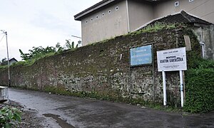
There are 2 palace sites, keraton of Kartosuro in kelurahan of Kartosuro and keraton of Pajang's ruin in kelurahan of Makamhaji.
Further reading
- Miksic, John (general ed.), et al. (2006) Karaton Surakarta. A look into the court of Surakarta Hadiningrat, central Java (First published: 'By the will of His Serene Highness Paku Buwono XII'. Surakarta: Yayasan Pawiyatan Kabudayan Karaton Surakarta, 2004) Marshall Cavendish Editions Singapore ISBN 981-261-226-2
- Pemberton, John, (1994) On the subject of "Java" Ithaca : Cornell University Press.ISBN 0-8014-2672-3
- Ricklefs, M.C. (1978) Modern Javanese historical tradition: A study of an original Kartasura chronicle and related materials. London : School of Oriental and African Studies.
- Ricklefs, M.C. (1993) War, culture and economy in Java, 1677–1726: Asian and European imperialism in the early Kartasura period. Sydney : Asian Studies Association of Australia in association with Allen and Unwin.
