
Poomala: Difference between revisions
m commonscat |
m Bot: Migrating 1 interwiki links, now provided by Wikidata on d:q4251350 |
||
| Line 29: | Line 29: | ||
{{Thrissur-geo-stub}} |
{{Thrissur-geo-stub}} |
||
[[ml:പൂമല]] |
|||
Revision as of 04:29, 18 March 2013

Poomala is a village in Thrissur district of Kerala, South India. It is 16 km from the town of Thrissur.
Etymology
Poomala's name comes from the Poovam tree (also called Ceylon oak or Gum-lac tree), which was plentiful here in the past.
Description
Poomala was largely a forest, until the area was occupied by the Christian settlers from central Travancore. It is one of the popular tourist hill stations in India. Attractions include Muniarra (a cave where a saint once meditated). The small dam in the southern part of Poomala was initially built only for irrigation purposes, then managed by the Minor Irrigation Department. Today, it is a growing tourist area as well, as the District Tourism Promotion Council (DTPC) of Thrissur undertook a 50 lakh project that was launched in 2008 to beautify the environs of the dam. Poomala dam was officially designated as a tourist centre by the Home Minister of State, Kodiyeri Balakrishnan, on 21 March 2010. The dam is situated 94.50 meters above mean sea level. To its north lies another dam, Pathazhakundu, which presently is oriented only for irrigation. There are some more villages named Parambayi, Poomala, Chottupara. Nowadays these villages are known together as Poomala. As like the Name 'Poomala', it is nice to see with full of greenaries,
-
 A view from Poomala
 -
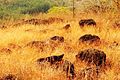 Poomala hill
 -
 Poomala hill
 -
 Poomala hill
 -
 A view from Poomala hill
 -
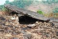 Muniarra (cave where a saint once meditated)
 -
 Muniarra (cave where a saint once meditated)


This article related to a location in Thrissur district, Kerala, India is a stub. You can help Wikipedia by expanding it. |