Stromberg (Hunsrück): Difference between revisions
Appearance
Content deleted Content added
m add category using AWB |
|||
| Line 30: | Line 30: | ||
{{Cities and towns in Bad Kreuznach (district)}} |
{{Cities and towns in Bad Kreuznach (district)}} |
||
==References== |
==References== |
||
{{Reflist}} |
{{Reflist}} |
||
[[Category:Bad Kreuznach (district)]] |
|||
{{BadKreuznach-geo-stub}} |
{{BadKreuznach-geo-stub}} |
||
Revision as of 14:34, 16 February 2014
Stromberg | |
|---|---|
 | |
| Land | Deutschland |
| State | Rhineland-Palatinate |
| District | Bad Kreuznach |
| Municipal assoc. | Stromberg |
| Regierung | |
| • Mayor | Achim Schöffel (CDU) |
| Area | |
| • Total | 9.02 km2 (3.48 sq mi) |
| Elevation | 220 m (720 ft) |
| Population (2022-12-31)[1] | |
| • Total | 3,477 |
| • Density | 390/km2 (1,000/sq mi) |
| Time zone | UTC+01:00 (CET) |
| • Summer (DST) | UTC+02:00 (CEST) |
| Postal codes | 55442 |
| Dialling codes | 06724 |
| Vehicle registration | KH |
| Website | www.stadt-stromberg.de |
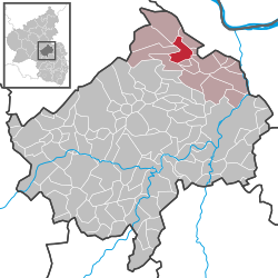
Stromberg is a municipality in the district of Bad Kreuznach, in Rhineland-Palatinate, Germany. It is situated on the eastern edge of the Hunsrück, approx. 10 km west of Bingen.
Stromberg is the seat of the Verbandsgemeinde ("collective municipality") Stromberg.
Wikimedia Commons has media related to Stromberg (Hunsrück).
References
- ^ "Bevölkerungsstand 2022, Kreise, Gemeinden, Verbandsgemeinden" (PDF) (in German). Statistisches Landesamt Rheinland-Pfalz. 2023.


