
North Carolina Highway 305: Difference between revisions
m added categories |
|||
| Line 18: | Line 18: | ||
==Route description== |
==Route description== |
||
NC 305 |
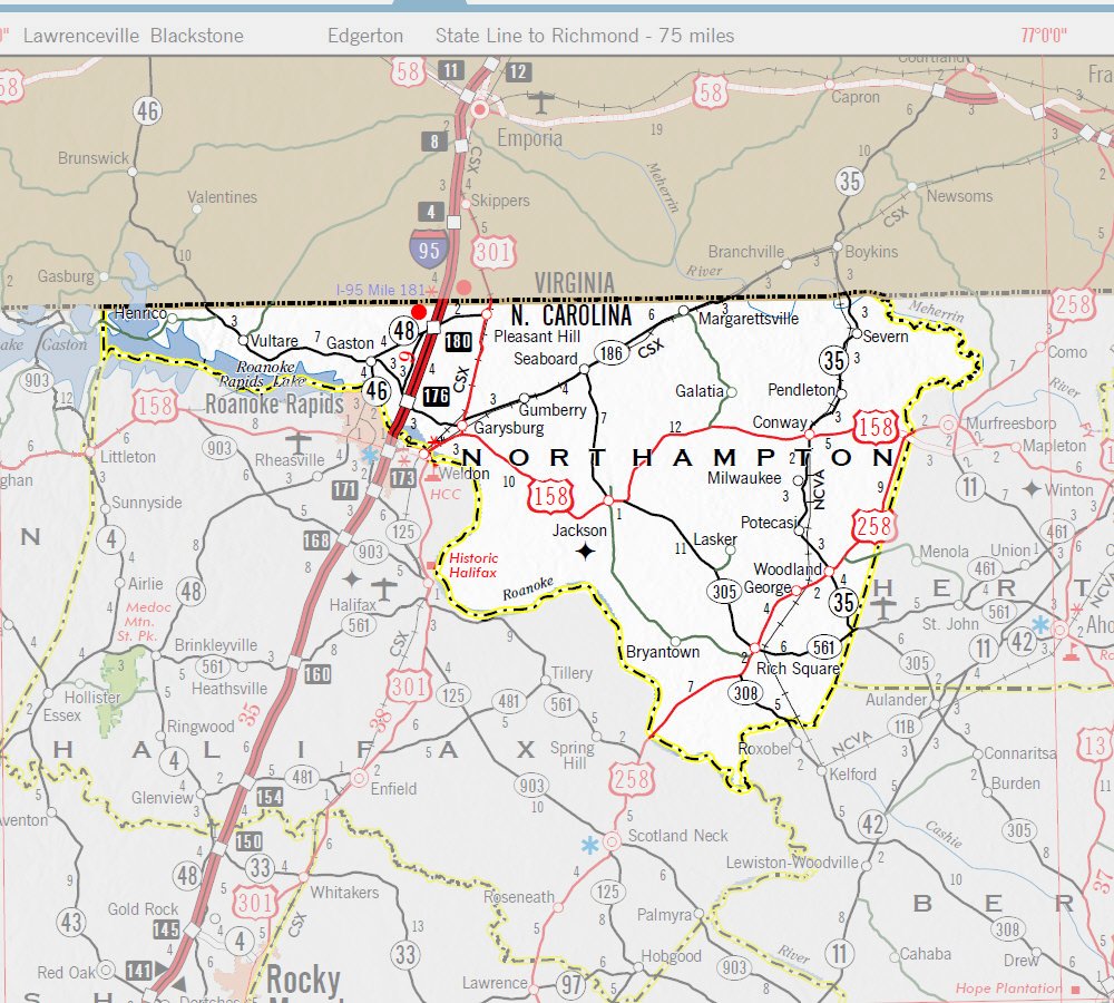
NC 305 begins at an intersection with US 13 north of Windsor. NC 305 then heads northwest towards Burden and Connarlsta. It then crosses NC 11/NC 42 near Aulander then goes through downtown Aulander.<ref name="ref-966269996">{{cite web|url=http://dotw-xfer01.dot.state.nc.us/imgdot/DOTStateTravelMap/bertie.jpg|title=imgdot/DOTStateTravelMap/bertie|publisher=dotw-xfer01.dot.state.nc.us|accessdate=2014-02-14}}</ref> NC 305 then continues into the southwestern side of Hertford County. NC 305 meets up with NC 561 near Northampton County. NC 305 and NC 561 run a concurrency until Rich Square where it crosses US 258.<ref name="ref-1326503734">{{cite web|url=http://dotw-xfer01.dot.state.nc.us/imgdot/DOTStateTravelMap/hertford.jpg|title=imgdot/DOTStateTravelMap/hertford|publisher=dotw-xfer01.dot.state.nc.us|accessdate=2014-02-14}}</ref> NC 305 then heads a northwesterly direction towards Jackson. NC 305 then runs a concurrency with US 158 west into Jackson before it turns north towards Seaboard. After 7 miles NC 305 reaches its northern terminus of NC 186 in Seaboard.<ref name="ref-955663573">{{cite web|url=http://dotw-xfer01.dot.state.nc.us/imgdot/DOTStateTravelMap/northampton.jpg|title=imgdot/DOTStateTravelMap/northampton|publisher=dotw-xfer01.dot.state.nc.us|accessdate=2014-02-14}}</ref> |
||
==History== |
==History== |
||
Revision as of 10:28, 27 March 2014
This article may require copy editing for grammar, style, cohesion, tone, or spelling. (February 2014) |
North Carolina Highway 305 | |
|---|---|
 | |
| Route information | |
| Maintained by NCDOT | |
| Length | 44.7 mi[1] (71.9 km) |
| Existed | 1921–present |
| Major junctions | |
| south end | |
| north end | |
| Standort | |
| Land | Vereinigte Staaten |
| State | North Carolina |
| Counties | Bertie, Hertford, Northampton |
| Highway system | |

North Carolina Highway 305 (NC 305) is a north–south state highway in central and eastern North Carolina. NC 305 runs from NC 186 in Seaboard to US Highway 13 (US 13) north of Windsor. NC 305 is an original state highway and appeared on the 1936 official map of North Carolina from Seaboard to Aulander.[2] NC 305 has an average of 1663 cars per day on the route.[3]
Route description
NC 305 begins at an intersection with US 13 north of Windsor. NC 305 then heads northwest towards Burden and Connarlsta. It then crosses NC 11/NC 42 near Aulander then goes through downtown Aulander.[4] NC 305 then continues into the southwestern side of Hertford County. NC 305 meets up with NC 561 near Northampton County. NC 305 and NC 561 run a concurrency until Rich Square where it crosses US 258.[5] NC 305 then heads a northwesterly direction towards Jackson. NC 305 then runs a concurrency with US 158 west into Jackson before it turns north towards Seaboard. After 7 miles NC 305 reaches its northern terminus of NC 186 in Seaboard.[6]
History
The first time NC 305 appeared on a map was on the 1922 official map of North Carolina. The road went from Jackson to Rich Square and then to Aulander.[7] By 1930 NC 305 was extended north to its current terminus in Seaboard, North Carolina.[8] By 1940 NC 305 had been extended down south to NC 97 north of Windsor, North Carolina.[9] When US 13 was extended south NC 97 was renumbered as part of US 13. When NC 561 was extended NC 305 was built to run a concurrency with NC 561 for 6 miles.[10] NC 305 has had the same routing since then.
Junction list
| County | Standort | mi[11] | km | Destinations | Notes |
|---|---|---|---|---|---|
| Bertie | Windsor | 0.00 | 0.00 | Southern terminus | |
| Aulander | 13 | 21 | |||
| Hertford | Woodland | 19 | 31 | Eastern end of NC 561 concurrency | |
| Northampton | 19.6 | 31.5 | |||
| Rich Square | 26 | 42 | Western end of NC 561 concurrency | ||
| Jackson | 37 | 60 | Western end of US 158 concurrency | ||
| 38 | 61 | Eastern end of US 158 concurrency | |||
| Seaboard | 44.7 | 71.9 | Northern terminus | ||
1.000 mi = 1.609 km; 1.000 km = 0.621 mi
| |||||
References
- ^ "Main St to NC-305 - Google Maps". google.com. Retrieved 2014-02-14.
- ^ "North Carolina Maps: Historic Overlay Maps: State Highway System of North Carolina, 1936". www2.lib.unc.edu. Retrieved 2014-02-14.
- ^ "NCDOT: Traffic Volume Maps". ncdot.gov. Retrieved 2014-02-14.
- ^ "imgdot/DOTStateTravelMap/bertie". dotw-xfer01.dot.state.nc.us. Retrieved 2014-02-14.
- ^ "imgdot/DOTStateTravelMap/hertford". dotw-xfer01.dot.state.nc.us. Retrieved 2014-02-14.
- ^ "imgdot/DOTStateTravelMap/northampton". dotw-xfer01.dot.state.nc.us. Retrieved 2014-02-14.
- ^ State highway system of North Carolina (Map) (1922 ed.). Cartography by North Carolina Public Works Commission. North Carolina State Highway Commission. 1922.
- ^ State highway system of North Carolina (Map) (1930 ed.). Cartography by North Carolina Public Works Commission. North Carolina State Highway Commission. 1930.
- ^ North Carolina Primary Highway System (Map) (1940 ed.). Cartography by North Carolina Public Works Commission. North Carolina State Highway Commission. 1940.
- ^ North Carolina Highway System (Map) (1960 ed.). Cartography by North Carolina Public Works Commission. North Carolina State Highway Commission. 1960.
- ^ 2011-2012 North Carolina State Transportation map (Map) (2011-2012 ed.). Cartography by North Carolina Public Works Commission. North Carolina Department of Transportation. 2011.