Krasnoperekopsk Raion: Difference between revisions
Appearance
Content deleted Content added
No edit summary |
Adding geodata: {{coord|45|58|03|N|33|48|01|E|type:adm2nd_source:kolossus-itwiki|display=title}} |
||
| Line 62: | Line 62: | ||
{{Subdivisions of Crimea}} |
{{Subdivisions of Crimea}} |
||
{{coord missing|Ukraine}} |
|||
{{coord|45|58|03|N|33|48|01|E|type:adm2nd_source:kolossus-itwiki|display=title}} |
|||
| ⚫ | |||
| ⚫ | |||
{{Crimea-geo-stub}} |
{{Crimea-geo-stub}} |
||
Revision as of 13:06, 19 April 2014
Krasnoperekopsk Raion
Красноперекопський район | |
|---|---|
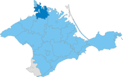
 Raion location within Crimea | |
| Country | Disputed |
| Republic | Crimea |
| Capital | Krasnoperekopsk |
| Subdivisions | List
|
| Area | |
| • Total | 1,231 km2 (475 sq mi) |
| Population | |
| • Total | 31,843 |
| • Density | 26/km2 (67/sq mi) |
| Time zone | UTC+4 (MSK) |
| Dialing code | +380-6565 |
Krasnoperekopsk Raion (Ukrainian: Красноперекопський район, Russian: Красноперекопский район, Crimean Tatar: Krasnoperekopsk rayonı) is one of the 25 regions of the Autonomous Republic of Crimea, a territory recognized by a majority of countries as part of Ukraine and incorporated by Russia as the Republic of Crimea. It is situated in the northern part of the republic.

