
Aberdare Park: Difference between revisions
Marianna251 (talk | contribs) m Reverted edits by 79.67.56.125 (talk) (HG) (3.1.21) |
Rescuing 1 sources and tagging 0 as dead. #IABot (v1.2.4) |
||
| Line 55: | Line 55: | ||
==External links== |
==External links== |
||
* [http://aberdarepark.co.uk/amcc_home_page.asp Aberdare Road Races] |
* [https://web.archive.org/web/20080820095824/http://www.aberdarepark.co.uk/amcc_home_page.asp Aberdare Road Races] |
||
* [http://www.flickr.com/groups/aberdare-park/ Aberdare Park Photos on Flickr] |
* [http://www.flickr.com/groups/aberdare-park/ Aberdare Park Photos on Flickr] |
||
Revision as of 16:32, 2 October 2016

Aberdare Park (Welsh: Parc Aberdâr) is a well-preserved Victorian public park located in the village of Trecynon, near the town of Aberdare in South Wales.
History
The park occupies nearly fifty acres (20.25ha). It opened on 27 July 1869. It was landscaped and planted by William Barron who had laid out many parks in England. The park was created at the instigation of Rees Hopkin Rhys.
In 1956 the National Eisteddfod was held in the park. A gorsedd circle was erected to commemorate this event, the stone circle still remaining.
The park is the location of the annual Aberdare Park National Road Races, which is a motorcycle race held on the 0.9-mile (1.4 km) circuit within the park. The road races in 2011 were held on the weekend of July 9th & 10th
The track is the only track in the country which takes a left course. It is also one of the best on the country, and the hardest.
Sculptures and Features
Visitors to the park are greeted by the prominent sculpture of Sir William T. Lewis (Lord Merthyr). Unveiled in 1913, the sculptor was Thomas Brock.
Trees
The park contains a mixture of native and exotic trees most of which date back to the Victorian era, the following trees can be found at the park.
- Araucariaceae; Araucaria araucana (monkey puzzle tree)
- Birch; Betula pendula
- Beech; Fagus sylvatica
- Cedars; Cedrus atlantica, Cedrus libani
- Hawthorn; Crataegus monogyna
- Maples; Acer palmatum, Acer campestre, Acer platanoides, Acer pseudoplatanus
- Pines; Pinus nigra, Pinus wallichiana
- Poplar; Populus nigra 'Italica'
- Oaks; Quercus robur, Quercus ilex
- Cherries; Prunus serrulata
- Chestnuts; Castanea sativa
- Redwoods; Sequoiadendron giganteum, Sequoia sempervirens, Metasequoia
- Spruce; Picea sitchensis
- Willows; Salix 'Chrysocoma'
- Yew; Taxus baccata
Gallery
-
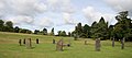 Gorsedd stones as used for the National Eisteddfod
 -
 An inquisitive Canada goose
 -
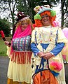 Having fun at Aberdare Carnival
 -
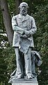 Lord Merthyr sculpture by Thomas Brock


See also
51°43′09″N 3°27′30″W / 51.71917°N 3.45833°W