Kampong Thom city: Difference between revisions
Appearance
Content deleted Content added
No edit summary |
No edit summary |
||
| Line 1: | Line 1: | ||
<!-- Infobox begins --> |
<!-- Infobox begins --> |
||
{{Infobox settlement |
{{Infobox settlement |
||
|official_name = |
|official_name = Steung Saen |
||
|other_name = |
|other_name = |
||
|native_name = {{nobold|{{lang|km|ក្រុងស្ទឹងសែន}}}} |
|native_name = {{nobold|{{lang|km|ក្រុងស្ទឹងសែន}}}} |
||
| Line 9: | Line 9: | ||
|image_skyline = Kampong Thom.jpg |
|image_skyline = Kampong Thom.jpg |
||
|imagesize = |
|imagesize = |
||
|image_caption = |
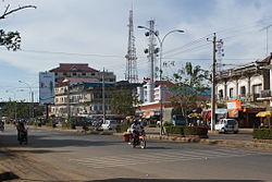
|image_caption = Steung Saen |
||
|image_flag = |
|image_flag = |
||
|flag_size = |
|flag_size = |
||
| Line 20: | Line 20: | ||
|image_map = |
|image_map = |
||
|mapsize = |
|mapsize = |
||
|map_caption = Location of |
|map_caption = Location of Steung Saen, Cambodia |
||
|image_map1 = |
|image_map1 = |
||
|mapsize1 = |
|mapsize1 = |
||
Revision as of 08:09, 2 January 2017
Steung Saen
ក្រុងស្ទឹងសែន | |
|---|---|
 Steung Saen | |
| Country | |
| Province | Kampong Thom |
| District | Stueng Saen District |
| Elevation | 10 m (30 ft) |
| Population (2008) | |
| • Total | 31,871 |
| Time zone | UTC+7 (Cambodia) |
Steung Saen (Khmer: ក្រុងស្ទឹងសែន) is the capital city of Kampong Thom Province, Cambodia lying on the bank of the Stung Sen River. It is served by the national highway, going from Siem Reap to Phnom Penh.
Wikivoyage has a travel guide for Kampong Thom.
