
Gbadolite: Difference between revisions
m Reverted edits by 124.72.154.250 (talk): Introduces factual errors (HG) (3.1.22) |
JJMC89 bot (talk | contribs) Migrate {{Infobox settlement}} coordinates parameters to {{Coord}}, see Wikipedia:Coordinates in infoboxes |
||
| Line 6: | Line 6: | ||
| pushpin_map = Democratic Republic of the Congo |
| pushpin_map = Democratic Republic of the Congo |
||
| map_caption = Location in the [[Democratic Republic of the Congo]] |
| map_caption = Location in the [[Democratic Republic of the Congo]] |
||
| coordinates_region = CD |
|||
| subdivision_type = Country |
| subdivision_type = Country |
||
| subdivision_name = [[DR Congo]] |
| subdivision_name = [[DR Congo]] |
||
| Line 34: | Line 33: | ||
| timezone = [[West Africa Time|WAT]] |
| timezone = [[West Africa Time|WAT]] |
||
| utc_offset = +1 |
| utc_offset = +1 |
||
| coordinates = {{coord|4|17|N|21|01|E|region:CD|display=inline}} |
|||
| latd = 4 | latm = 17 | lats = | latNS = N |
|||
| longd = 21 | longm = 01 | longs = | longEW = E |
|||
| elevation_footnotes = |
| elevation_footnotes = |
||
| elevation_ft = |
| elevation_ft = |
||
Revision as of 04:26, 5 March 2017
Gbadolite | |
|---|---|
| Ville de Gbadolite | |
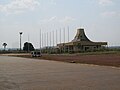
 Aerial view of the town | |
 Gbadolite Location in the Democratic Republic of the Congo | |
| Coordinates: 4°17′N 21°01′E / 4.283°N 21.017°E | |
| Land | DR Congo |
| Province | Nord-Ubangi |
| Zone (territoire) de Gbadolite | December 8, 1972[1] |
| Cité de Gbadolite | March 25, 1982[1] |
| Ville de Gbadolite | January 10, 1987[1] |
| Regierung | |
| • Mayor | Ngbabesi Crispin[2] |
| Area | |
| • Total | 278 km2 (107 sq mi) |
| Elevation | 462 m (1,516 ft) |
| Population (2004)[1] | |
| • Total | 113,807 |
| • Density | 408/km2 (1,060/sq mi) |
| Time zone | UTC+1 (WAT) |
| Climate | Am |
Gbadolite or Gbado-Lite (pronounced [ɡ͡badolite]) is the capital of Nord-Ubangi Province in the Democratic Republic of the Congo. The town is located 12 kilometres (7.5 mi) south of the Ubangi River at the border to the Central African Republic and 1,150 kilometres (710 mi) northeast of the national capital Kinshasa. Gbadolite was the ancestral home and residence of Joseph-Désiré Mobutu, lafter self-styled as Mobutu Sese Seko, the President of Zaire from 1965 to 1997.
History
Mobutu built Gbadolite into a luxurious town often nicknamed "Versailles of the Jungle".[3] He built a hydroelectric dam on the nearby Ubangi River in Mobayi Mbongo, an international airport, Gbadolite Airport, which could accommodate Concorde, and three large palaces. As a result, the people of the town had no trouble finding jobs, often as servants. During Mobutu's regime, Gbadolite had also companies such as CDIA Zaire for farming productions, SOZAGEC for road constructions, and SAFRICAS for house constructions. The town had a General Hospital with high tech facilities which were destroyed in 1997. Gbadolite had also College Presidentiel, a high school famous for its academic excellence and administered by Jesuit Fathers to whom Mobutu gave the school. This School had a chemistry lab, physics lab, computer lab, olympic game facilities, band instruments of all kinds. The town was also famous for its Chapelle Marie la Misericorde, a luxurious church in which Mobutu buried his first wife Mama Mobutu.
Two palaces were built outside Gbadolite at Kawele. One an elaborate complex of Chinese pagodas and the other a modern mansion, these were used as residences for Mobutu and guests. The three story palace in Gbadolite was used primarily for public functions.
Mobutu also built a nuclear bunker that could house more than 500 people and was the largest in Africa; this was the only nuclear bunker in Central Africa. The bunker was connected to the Ubangui River by a secret tunnel, giving access to the military harbour at the village of N'dangi.[4]
When Laurent Kabila successfully led a rebellion and ousted Mobutu from power in 1997, Gbadolite was raided, and most of what was in the palaces was looted. The palaces are now being overrun by vegetation.
In 1998 the Ugandan backed MLC (Mouvement de Libération du Congo) rebel group, led by Jean-Pierre Bemba, captured Gbadolite from Kabila's government and it became the MLC's headquarters.
Gallery
-
 Site of the former Mobutu palace (ransacked)
 -
 Soldiers belonging to opposition forces in Gbadolite
 -
 Gbadolite Airport


See also
References
- ^ a b c d e "Villes de RD Congo - Gbado-Lite" (in French). MONUC. 2006-05-29. Retrieved 2008-09-16.
- ^ "Nomination dans la territoriale : Les maires et les bourgmestres désignés" (in French). Réseau d'Organisations des Droits Humains et d'Education Civique d'Inspiration Chrétienne (RODHECIC). 2005-07-14. Retrieved 2008-09-23.
- ^ "Legacy of corrupt and ruthless dictator who built Versailles in the jungle". London: The Independent. May 5, 1997. Retrieved December 17, 2010.
- ^ L'Express, 22 December 2008, page 13
Bibliography
- Nagifi, Valentin (2003). Les derniers jours de Mobutu à Gbado-Lite (Congo-Zaïre) (in French) (Archive congolaise ed.). Paris: L'Harmattan. ISBN 2-7475-3623-8.
External links
- Smith, David (10 February 2015). "Where Concorde once flew: the story of President Mobutu's 'African Versailles'". The Guardian.
- "Inside Mobutu's ruined jungle palace in DR Congo". BBC. 8 October 2013.
4°17′N 21°01′E / 4.283°N 21.017°E
Capitals of the provinces of the Democratic Republic of the Congo | ||
|---|---|---|
|  | |
Provinces are shown between brackets | ||