
Münstermaifeld: Difference between revisions
Bermicourt (talk | contribs) m |
Bermicourt (talk | contribs) links |
||
| Line 22: | Line 22: | ||
|party = WG Pro-MM |
|party = WG Pro-MM |
||
}} |
}} |
||
'''Münstermaifeld''' (<small>German pronunciation:</small> [[International Phonetic Alphabet|[ˌmʏnstɐˈmaɪfɛlt]]]) is a town in the district [[Mayen-Koblenz]], in [[Rhineland-Palatinate]], [[Germany]]. It is part of the ''[[Verbandsgemeinde]]'' ("collective municipality") of [[Maifeld (Verbandsgemeinde)|Maifeld]]. It is situated south-east of [[Mayen]], a few |
'''Münstermaifeld''' (<small>German pronunciation:</small> [[International Phonetic Alphabet|[ˌmʏnstɐˈmaɪfɛlt]]]) is a town in the district [[Mayen-Koblenz]], in [[Rhineland-Palatinate]], [[Germany]]. It is part of the ''[[Verbandsgemeinde]]'' ("collective municipality") of [[Maifeld (Verbandsgemeinde)|Maifeld]]. It is situated south-east of [[Mayen]], a few kilometres from the [[Moselle]] river and [[Eltz Castle]]. The first (B.C.) residents of the region were Celts. The old church is based on a Roman castle-tower. After the Romans, the Franks ([[Charlemagne]]) arrived in the 9th century. In the Middle Ages (1277) Münstermaifeld received town privileges and was governed by the [[bishop of Trier]]. It is one of the oldest towns in [[Rhineland-Palatinate]] and, with its 3,400 citizens, one of the smallest. |
||
==Mayors== |
==Mayors== |
||
Revision as of 19:08, 1 January 2018
Münstermaifeld | |
|---|---|
 Coat of arms | |
Location of Münstermaifeld within Mayen-Koblenz district  | |
 Münstermaifeld  Münstermaifeld | |
| Coordinates: 50°14′51″N 7°21′47″E / 50.24750°N 7.36306°E | |
| Land | Deutschland |
| State | Rhineland-Palatinate |
| District | Mayen-Koblenz |
| Municipal assoc. | Maifeld (Verbandsgemeinde) |
| Subdivisions | 6 |
| Regierung | |
| • Mayor | Robert Müller (WG Pro-MM) |
| Area | |
| • Total | 27.78 km2 (10.73 sq mi) |
| Elevation | 271 m (889 ft) |
| Population (2022-12-31)[1] | |
| • Total | 3,443 |
| • Density | 120/km2 (320/sq mi) |
| Time zone | UTC+01:00 (CET) |
| • Summer (DST) | UTC+02:00 (CEST) |
| Postal codes | 56294 |
| Dialling codes | 02605 |
| Vehicle registration | MYK |
| Website | www.muenstermaifeld.de |
Münstermaifeld (German pronunciation: [ˌmʏnstɐˈmaɪfɛlt]) is a town in the district Mayen-Koblenz, in Rhineland-Palatinate, Germany. It is part of the Verbandsgemeinde ("collective municipality") of Maifeld. It is situated south-east of Mayen, a few kilometres from the Moselle river and Eltz Castle. The first (B.C.) residents of the region were Celts. The old church is based on a Roman castle-tower. After the Romans, the Franks (Charlemagne) arrived in the 9th century. In the Middle Ages (1277) Münstermaifeld received town privileges and was governed by the bishop of Trier. It is one of the oldest towns in Rhineland-Palatinate and, with its 3,400 citizens, one of the smallest.
Mayors
- up to 2009: Maximilian Mumm
- 2009–2014: Robert Müller
- since: 2014: Claudia Schneider (CDU)[2]
Born in Münstermaifeld

- Julia Drusilla (16-38), sister of the Emperor Caligula
- Jakob von Eltz-Rübenach (1510–1581) Archbishop-Elector of Trier from 1567 to 1581
- Franz Josef Ignaz Canaris (1791-1828), great-grandfather of Wilhelm Canaris
- Anton Josef Dräger (1794-1833), painter
- Heinrich Klee (1800-1840), Catholic theologian
- Johann Martin Josef Canaris (1817-1894), grandfather of Wilhelm Canaris
- Joseph Wolf (1820-1899), animal painter
- Thomas Anders (born 1963), pop singer and music producer
References
-
 Cathedral in Münstermaifeld
 -
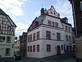 Town hall of Münstermaifeld
 -
 "Holy Sepulchre - Entombment of Christ" sculpture in the Maifeldmünster church


External links

| International | |
|---|---|
| National | |
This Mayen-Koblenz location article is a stub. You can help Wikipedia by expanding it. |