District 10, Ho Chi Minh City: Difference between revisions
Appearance
Content deleted Content added
No edit summary |
No edit summary Tags: Visual edit Mobile edit Mobile web edit |
||
| Line 1: | Line 1: | ||
{{Infobox settlement |
{{Infobox settlement |
||
| name = District 10 |
| name = District 10 |
||
| |
| official_name = |
||
| |
| native_name = Quận 10 |
||
| type = [[List of urban districts of Vietnam|Urban district]] |
| native_name_lang = vi |
||
| type = [[List of urban districts of Vietnam|Urban district]] |
|||
| image_skyline = |
| image_skyline = |
||
| image_alt = |
| image_alt = |
||
| image_caption = |
| image_caption = |
||
| nickname = |
| nickname = |
||
| image_map = VN-F-HC-Q10 position in city core.png |
| image_map = VN-F-HC-Q10 position in city core.png |
||
| map_alt = |
| map_alt = |
||
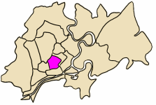
| map_caption = Position in HCMC's core |
| map_caption = Position in HCMC's core |
||
| pushpin_map = Vietnam |
| pushpin_map = Vietnam |
||
| pushpin_label_position = |
| pushpin_label_position = |
||
| pushpin_map_alt = |
| pushpin_map_alt = |
||
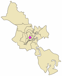
| pushpin_map_caption = Location in Vietnam |
| pushpin_map_caption = Location in Vietnam |
||
| coordinates = {{coord|10|46|25|N|106|40|2|E|region:VN_type:city|display=inline,title}} |
| coordinates = {{coord|10|46|25|N|106|40|2|E|region:VN_type:city|display=inline,title}} |
||
| coor_pinpoint = |
| coor_pinpoint = |
||
| coordinates_footnotes = |
| coordinates_footnotes = |
||
| subdivision_type = Country |
| subdivision_type = Country |
||
| subdivision_name = {{flag|Vietnam}} |
| subdivision_name = {{flag|Vietnam}} |
||
| subdivision_type1 = [[Direct-controlled municipality#Vietnam|Centrally governed city]] |
| subdivision_type1 = [[Direct-controlled municipality#Vietnam|Centrally governed city]] |
||
| subdivision_name1 = [[Ho Chi Minh City]] |
| subdivision_name1 = [[Ho Chi Minh City]] |
||
| established_title = |
| established_title = |
||
| established_date = |
| established_date = |
||
| founder = |
| founder = |
||
| seat_type = Seat |
| seat_type = Seat |
||
| seat = 474 Ba Thang Hai |
| seat = 474 Ba Thang Hai |
||
| government_footnotes = |
| government_footnotes = |
||
| leader_title = [[Provinces of Vietnam#People's Council|People's Council]] |
| leader_title = [[Provinces of Vietnam#People's Council|People's Council]] |
||
| leader_name = |
| leader_name = |
||
| leader_title1 = [[Provinces of Vietnam#People's Committee|People's Committee]] |
| leader_title1 = [[Provinces of Vietnam#People's Committee|People's Committee]] |
||
| leader_name1 = |
| leader_name1 = |
||
| unit_pref = Metric |
| unit_pref = Metric |
||
| area_footnotes = |
| area_footnotes = |
||
| area_total_km2 = 6 |
| area_total_km2 = 6 |
||
| area_note = |
| area_note = |
||
| elevation_footnotes = |
| elevation_footnotes = |
||
| elevation_m = |
| elevation_m = |
||
| population_footnotes = |
| population_footnotes = |
||
| population_total |
| population_total = 372,450 |
||
| population_as_of = |
| population_as_of = 2013 |
||
| population_density_km2 = auto |
| population_density_km2 = auto |
||
| population_demonym = |
| population_demonym = |
||
| population_note = |
| population_note = |
||
| parts_type = Wards |
| parts_type = Wards |
||
| parts_style = para |
| parts_style = para |
||
| p1 = 15 phường |
| p1 = 15 phường |
||
| demographics_type1 = Demographics |
| demographics_type1 = Demographics |
||
| demographics1_footnotes = |
| demographics1_footnotes = |
||
| demographics1_title1 = Main ethnic groups |
| demographics1_title1 = Main ethnic groups |
||
| demographics1_info1 = predominantly [[Kinh]] |
| demographics1_info1 = predominantly [[Kinh]] |
||
| timezone1 = ICT |
| timezone1 = ICT |
||
| utc_offset1 = +07 |
| utc_offset1 = +07 |
||
| postal_code_type = |
| postal_code_type = |
||
| postal_code = |
| postal_code = |
||
| area_code_type = |
| area_code_type = |
||
| area_code = |
| area_code = |
||
| iso_code = |
| iso_code = |
||
| website = [http://www.quan10.hochiminhcity.gov.vn/ quan10.hochiminhcity.gov.vn] |
| website = [http://www.quan10.hochiminhcity.gov.vn/ quan10.hochiminhcity.gov.vn] |
||
| footnotes = |
| footnotes = |
||
}} |
}} |
||
Revision as of 03:33, 15 February 2019
District 10
Quận 10 | |
|---|---|
 Position in HCMC's core | |
| Coordinates: 10°46′25″N 106°40′2″E / 10.77361°N 106.66722°E | |
| Land | |
| Centrally governed city | Ho Chi Minh City |
| Seat | 474 Ba Thang Hai |
| Wards | 15 phường |
| Area | |
| • Total | 6 km2 (2 sq mi) |
| Population (2013) | |
| • Total | 372,450 |
| • Density | 62,000/km2 (160,000/sq mi) |
| Demographics | |
| • Main ethnic groups | predominantly Kinh |
| Time zone | UTC+07 (ICT) |
| Website | quan10.hochiminhcity.gov.vn |
District 10 (Vietnamese: Quận 10) is an urban district (quận) of Ho Chi Minh City, the largest city in Vietnam.
As of 2010, the district had a population of 232,450, an area of 6 km².[1] It is divided into 15 small subsets which are called wards (phường), numbered from Ward 1 to Ward 15.
Geographical location

District 10 borders Tân Bình District to the north, District 5 to the south, District 3 to the east, and District 11 to the west.
References
- ^ "HCMC's Population and population density in 2010 by district". HCMC Office of Statistics. Retrieved Feb 4, 2014.


