Prior to the early 1940s, the term Cape Verde hurricane referred to August and early September storms that formed to the east of the surface plotting charts in use at the time.<ref name="Dunn1960">{{cite book|title=Atlantic Hurricanes|url=https://archive.org/details/atlantichurrican0000dunn|url-access=registration|author1=Gordon E. Dunn |author2=Banner I. Miller |publisher=[[Louisiana State University Press]]|date=1960|ASIN=B0006BM85S|page=[https://archive.org/details/atlantichurrican0000dunn/page/54 54]}}</ref> Cape Verde hurricanes typically develop from tropical waves which form in the African [[savanna]] during the [[wet season]], then move into the African [[steppe]]s. The disturbances move off the western coast of [[Africa]] and become [[tropical cyclones]] soon after moving off the coast,<ref name="A2">{{cite web|url=http://www.faqs.org/faqs/meteorology/storms-faq/part1/|title=FAQ: HURRICANES, TYPHOONS AND TROPICAL CYCLONES (Part 1 of 2) Subject: A2) What are "Cape Verde"-type hurricanes?|author=[[Chris Landsea]]|date=1997-07-18|publisher=Faqs.org|accessdate=2009-10-08}}</ref> within 10 to 15 degrees latitude, or {{convert|1100|km|mi}} to {{convert|1600|km|mi}}, of the [[Cape Verde]] Islands;<ref name="Dunn1960"/> this comprises the tropical latitudes east of the [[40th meridian west]]. In the years since the phrase's coining, increasing detection has allowed meteorologists to determine that Cape Verde hurricanes have formed as early as July 3 ([[Hurricane Bertha (2008)|Hurricane Bertha]] of [[2008 Atlantic hurricane season|2008]]) or as late as October 10 ([[Hurricane Joan–Miriam]] of [[1988 Atlantic hurricane season|1988]]).
Prior to the early 1940s, the term Cape Verde hurricane referred to August and early September storms that formed to the east of the surface plotting charts in use at the time.<ref name="Dunn1960">{{cite book|title=Atlantic Hurricanes|url=https://archive.org/details/atlantichurrican0000dunn|url-access=registration|author1=Gordon E. Dunn |author2=Banner I. Miller |publisher=[[Louisiana State University Press]]|date=1960|ASIN=B0006BM85S|page=[https://archive.org/details/atlantichurrican0000dunn/page/54 54]}}</ref> Cape Verde hurricanes typically develop from tropical waves which form in the African [[savanna]] during the [[wet season]], then move into the African [[steppe]]s. The disturbances move off the western coast of [[Africa]] and become [[tropical cyclones]] soon after moving off the coast,<ref name="A2">{{cite web|url=http://www.faqs.org/faqs/meteorology/storms-faq/part1/|title=FAQ: HURRICANES, TYPHOONS AND TROPICAL CYCLONES (Part 1 of 2) Subject: A2) What are "Cape Verde"-type hurricanes?|author=[[Chris Landsea]]|date=1997-07-18|publisher=Faqs.org|accessdate=2009-10-08}}</ref> within 10 to 15 degrees latitude, or {{convert|1100|km|mi}} to {{convert|1600|km|mi}}, of the [[Cape Verde]] Islands;<ref name="Dunn1960"/> this comprises the tropical latitudes east of the [[40th meridian west]]. In the years since the phrase's coining, increasing detection has allowed meteorologists to determine that Cape Verde hurricanes have formed as early as July 3 ([[Hurricane Bertha (2008)|Hurricane Bertha]] of [[2008 Atlantic hurricane season|2008]]) or as late as October 10 ([[Hurricane Joan–Miriam]] of [[1988 Atlantic hurricane season|1988]]).
==Typical tracks==
A Cape Verde hurricane forms from a tropical depression or tropical wave which passed through or near the Cape Verde islands, and strengthens into a named system (eventually becoming a hurricane at some point) in the mid-Atlantic. The initial track of a Cape Verde storm tends to be generally westward from Cape Verde, with a turn to the north at some stage in the track for most storms lasting more than a few days. Once the [[tropical cyclone]] begins approaching the 40th meridian west, a Cape Verde hurricane can take several basic tracks and from there diverge, become extra-tropical, or dissipate.
{{Clear}}
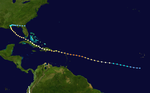
# [[Image:Joan 1988 track.png|thumb|right|150px|Joan (1988), on a southern track.]] It can continue to the west, and if it is far enough south, it will cross the [[Windward Islands]] into the [[Caribbean Sea]], possibly affecting [[Venezuela]] to some degree. From there it will often continue westward into [[Nicaragua]], [[Honduras]], or [[Belize]].<ref name="HURDAT"/> For example, [[Hurricane Joan–Miriam]] took this southerly route in [[1988 Atlantic hurricane season|1988]], causing severe flooding in [[South America]], making landfall in [[Central America]], and continuing into the [[Pacific Basin]], just as [[Hurricane Irene–Olivia]] did in [[1971 Atlantic hurricane season|1971]]. Rarely, a storm will [[List of South America tropical cyclones|make landfall in South America]].{{Clear}}
# [[Image:Allen 1980 track.png|thumb|right|150px|Allen (1980), on a Gulf of Mexico track.]] Some storms track towards the [[Yucatán Peninsula]] as they travel westward through the Caribbean, entering the [[Gulf of Mexico]] near its western extent. [[Hurricane Emily (2005)|Hurricane Emily]] of [[2005 Atlantic hurricane season|2005]] struck the Yucatán Peninsula before entering the Gulf and continuing northwest, skirting the [[Bay of Campeche]]. [[Hurricane Ivan]] of [[2004 Atlantic hurricane season|2004]] began with a very southerly route yet it made landfall far to the north in [[Alabama]]. Somewhere in the middle of these extremes, storms such as [[1980 Atlantic hurricane season|1980]]s [[Hurricane Allen]] pass unabated into the Gulf of Mexico on their way to landfall in [[Texas]] or [[Mexico]]. Many of these hurricanes strike [[Jamaica]] on their way to the Gulf, like the [[Galveston Hurricane of 1915]] and [[Hurricane Gilbert]] of [[1988 Atlantic hurricane season|1988]]. [[Hurricane Janet]] of [[1955 Atlantic hurricane season|1955]] is remembered as one of the deadliest and strongest storms to strike the Yucatán Peninsula of Mexico.{{Clear}}
# [[Image:Georges 1998 track.png|thumb|right|150px|Georges (1998), on a Caribbean track.]] If the storm is further north, it may travel past the [[Leeward Islands]] and into the [[Greater Antilles]]. In [[1998 Atlantic hurricane season|1998]], [[Hurricane Georges]] took a track of this nature as it continued into [[Mississippi]]. Slightly further north, and the storm will track through the [[Bahamas]] and into [[Florida]] in the manner of [[1992 Atlantic hurricane season|1992]]s [[Hurricane Andrew]].<ref name="HURDAT"/> Many of these storms passing through the center of the Caribbean will strike the islands of [[Hispaniola]] and [[Cuba]], like [[Hurricane David]] and [[Hurricane Frederic]] did, both in [[1979 Atlantic hurricane season|1979]]. Some storms on this track will turn to the west once in the Gulf, and thereby make landfall in Texas, as the [[Galveston Hurricane of 1900]] and [[Hurricane Ike]] of [[2008 Atlantic hurricane season|2008]] did. Similarly, [[Hurricane Inez]] of [[1966 Atlantic hurricane season|1966]] followed a Caribbean track that took the storm into the Bahamas where it weakened, only to turn sharply west and make a final landfall in Mexico.{{Clear}}
# [[Image:Gloria 1985 track.png|thumb|right|150px|Gloria (1985) struck the East Coast.]] A more northerly storm will often have its track affected by [[Azores High|the high pressure that typically occurs over the eastern Atlantic in late summer]]. As these storms pass north of the Antilles, their tracks begin to curve to the north and to the east of the Florida Peninsula, often sending them away from land. A few storms will track northwest, making landfall in [[North Carolina|North]] or [[South Carolina]]. [[Hurricane Hugo]] of [[1989 Atlantic hurricane season|1989]] and [[Hurricane Fran]] of [[1996 Atlantic hurricane season|1996]] are typical examples. Occasionally storms following this track can accelerate to the north and strike [[New England]]. The [[New England Hurricane of 1938]] and [[Hurricane Gloria]] in [[1985 Atlantic hurricane season|1985]] were two such cases.<ref name="HURDAT"/>{{Clear}}
# [[Image:Igor 2010 track.png|thumb|right|150px|Igor (2010) struck Atlantic Canada.]] When a storm tracks very far north, its potential for landfall is much less. Some of these storms will strike Bermuda before re-curving out to sea, such as the [[1948 Bermuda–Newfoundland hurricane]] and [[Hurricane Fabian]] in [[2003 Atlantic hurricane season|2003]]. Occasionally, the storm will track west-northwest to strike the Atlantic coast of the U.S., such as the [[1933 Chesapeake–Potomac hurricane]] and [[Hurricane Isabel]] of [[2003 Atlantic hurricane season|2003]], which struck the mid-Atlantic, and [[Hurricane Florence]] of [[2018 Atlantic hurricane season|2018]], which struck the Carolinas. Other Cape Verde storms make landfall in Canada, such as [[Hurricane Luis]] in [[1995 Atlantic hurricane season|1995]] and hurricanes [[Hurricane Earl (2010)|Earl]] and [[Hurricane Igor|Igor]] of [[2010 Atlantic hurricane season|2010]]. If the storm's track is affected significantly, it will often pass near the eastern U.S., [[Nova Scotia]], and [[Newfoundland (island)|Newfoundland Island]] and curve back out to sea, where it becomes extratropical over cooler water. An example of such was [[Hurricane Edouard (1996)|Hurricane Edouard]] in [[1996 Atlantic hurricane season|1996]]. At the extreme, Cape Verde hurricanes can track so far north as to curve all the way to Europe, such as [[Hurricane Debbie (1961)|Hurricane Debbie]] of [[1961 Atlantic hurricane season|1961]], [[Hurricane Isaac (2000)|Hurricane Isaac]] of [[2000 Atlantic hurricane season|2000]], and [[Hurricane Katia (2011)|Hurricane Katia]] of [[2011 Atlantic hurricane season|2011]], all of which affected [[Ireland]].{{Clear}}
# [[Image: Helene 2018 track.png|thumb|right|150px|Helene (2018) dissipated in the eastern Atlantic.]] Sometimes, the [[subtropical ridge]] is displaced from its normal position, which allows storms to recurve quickly by being driven around the east side of an upper trough in the central Atlantic, generally missing land completely as they dissipate. Both [[Hurricane Danielle (2004)|Hurricane Danielle]] and [[Hurricane Karl (2004)|Hurricane Karl]] were affected like this in [[2004 Atlantic hurricane season|2004]].<ref name="HURDAT"/> In other cases, storms are steered north very early in their development near Cape Verde, such as the [[1989 Atlantic hurricane season|1989]] storms [[Hurricane Erin (1989)|Erin]] and [[1989 Atlantic hurricane season#Hurricane Felix|Felix]], which both traveled northwest and never threatened land. However, in extremely rare cases, these storms will hit the Cape Verde islands or the [[Azores]] at a significant intensity. Two notable examples of this are [[Hurricane Fred (2015)|Hurricane Fred]], which hit Cape Verde in [[2015 Atlantic hurricane season|2015]], and [[1893 Atlantic hurricane season#Hurricane Seven|a hurricane]] which struck the Azores in [[1893 Atlantic hurricane season|1893]]; both of which caused considerable destruction.{{Clear}}
Because most Cape Verde hurricanes take a near-westward path that starts in the eastern Atlantic, they can avoid the two situations that typically end the life of a tropical cyclone: interaction with land, and movement over cool water. Since storms that far out at sea can go over a week without moving over cooler water or near a landmass, Cape Verde hurricanes are some of the longest-lived and farthest-traveling storms. [[Hurricane Faith (1966)|Hurricane Faith]] of [[1966 Atlantic hurricane season|1966]], the farthest-traveling Atlantic hurricane on record,{{Atlantic hurricane best track}} was a Cape Verde hurricane. It traveled 6,850 miles (11,020 km) and lasted a total of 16 days.<ref>{{cite book|page=161|title=Historical Climatology Series 6-2: Tropical Cyclones of the North Atlantic Ocean, 1851–2006 (with 2007 and 2008 track maps included)|author1=Colin J. McAdie |author2=Christopher W. Landsea |author3=Charles J. Neumann |author4=Joan E. David |author5=Eric S. Blake |author6=Gregory R. Hammer |url=http://www.nhc.noaa.gov/pdf/TC_Book_Atl_1851-2006_lowres.pdf|date=2009|accessdate=2009-10-08|publisher=National Climatic Data Center}}</ref> [[Hurricane Joan–Miriam]] of [[1988 Atlantic hurricane season|1988]] and [[Hurricane Irene–Olivia]] of [[1971 Atlantic hurricane season|1971]] lasted longer, both having crossed narrow parts of Central America and regaining cyclonic motion in the Pacific.
A Cape Verde hurricane or Cabo Verde hurricane is an Atlantic hurricane that originates at low-latitude in the deep tropics from a tropical wave that has passed over or near the Cape Verde islands after exiting the coast of West Africa. The average hurricane season has about two Cape Verde hurricanes, which are often the largest and most intense storms of the season due to having plenty of warm open ocean over which to develop before encountering land or other factors prompting weakening. A good portion of Cape Verde storms are large, and some, such as Hurricane Ivan, Hurricane Irma, and Hurricane Dorian have set various records. Most of the longest-lived tropical cyclones in the Atlantic basin are Cape Verde hurricanes. While many move harmlessly out to sea, some move across the Caribbean sea and into the Gulf of Mexico, becoming damaging storms for Caribbean nations, Central America, Mexico, Bermuda, the United States, and occasionally even Canada. Research projects since the 1970s have been launched to understand the formation of these storms.
Origin
Prior to the early 1940s, the term Cape Verde hurricane referred to August and early September storms that formed to the east of the surface plotting charts in use at the time.[1] Cape Verde hurricanes typically develop from tropical waves which form in the African savanna during the wet season, then move into the African steppes. The disturbances move off the western coast of Africa and become tropical cyclones soon after moving off the coast,[2] within 10 to 15 degrees latitude, or 1,100 kilometres (680 mi) to 1,600 kilometres (990 mi), of the Cape Verde Islands;[1] this comprises the tropical latitudes east of the 40th meridian west. In the years since the phrase's coining, increasing detection has allowed meteorologists to determine that Cape Verde hurricanes have formed as early as July 3 (Hurricane Bertha of 2008) or as late as October 10 (Hurricane Joan–Miriam of 1988).
Typical tracks
A Cape Verde hurricane forms from a tropical depression or tropical wave which passed through or near the Cape Verde islands, and strengthens into a named system (eventually becoming a hurricane at some point) in the mid-Atlantic. The initial track of a Cape Verde storm tends to be generally westward from Cape Verde, with a turn to the north at some stage in the track for most storms lasting more than a few days. Once the tropical cyclone begins approaching the 40th meridian west, a Cape Verde hurricane can take several basic tracks and from there diverge, become extra-tropical, or dissipate.
Allen (1980), on a Gulf of Mexico track. Some storms track towards the Yucatán Peninsula as they travel westward through the Caribbean, entering the Gulf of Mexico near its western extent. Hurricane Emily of 2005 struck the Yucatán Peninsula before entering the Gulf and continuing northwest, skirting the Bay of Campeche. Hurricane Ivan of 2004 began with a very southerly route yet it made landfall far to the north in Alabama. Somewhere in the middle of these extremes, storms such as 1980sHurricane Allen pass unabated into the Gulf of Mexico on their way to landfall in Texas or Mexico. Many of these hurricanes strike Jamaica on their way to the Gulf, like the Galveston Hurricane of 1915 and Hurricane Gilbert of 1988. Hurricane Janet of 1955 is remembered as one of the deadliest and strongest storms to strike the Yucatán Peninsula of Mexico.
Georges (1998), on a Caribbean track. If the storm is further north, it may travel past the Leeward Islands and into the Greater Antilles. In 1998, Hurricane Georges took a track of this nature as it continued into Mississippi. Slightly further north, and the storm will track through the Bahamas and into Florida in the manner of 1992sHurricane Andrew.[3] Many of these storms passing through the center of the Caribbean will strike the islands of Hispaniola and Cuba, like Hurricane David and Hurricane Frederic did, both in 1979. Some storms on this track will turn to the west once in the Gulf, and thereby make landfall in Texas, as the Galveston Hurricane of 1900 and Hurricane Ike of 2008 did. Similarly, Hurricane Inez of 1966 followed a Caribbean track that took the storm into the Bahamas where it weakened, only to turn sharply west and make a final landfall in Mexico.
Igor (2010) struck Atlantic Canada. When a storm tracks very far north, its potential for landfall is much less. Some of these storms will strike Bermuda before re-curving out to sea, such as the 1948 Bermuda–Newfoundland hurricane and Hurricane Fabian in 2003. Occasionally, the storm will track west-northwest to strike the Atlantic coast of the U.S., such as the 1933 Chesapeake–Potomac hurricane and Hurricane Isabel of 2003, which struck the mid-Atlantic, and Hurricane Florence of 2018, which struck the Carolinas. Other Cape Verde storms make landfall in Canada, such as Hurricane Luis in 1995 and hurricanes Earl and Igor of 2010. If the storm's track is affected significantly, it will often pass near the eastern U.S., Nova Scotia, and Newfoundland Island and curve back out to sea, where it becomes extratropical over cooler water. An example of such was Hurricane Edouard in 1996. At the extreme, Cape Verde hurricanes can track so far north as to curve all the way to Europe, such as Hurricane Debbie of 1961, Hurricane Isaac of 2000, and Hurricane Katia of 2011, all of which affected Ireland.
Helene (2018) dissipated in the eastern Atlantic. Sometimes, the subtropical ridge is displaced from its normal position, which allows storms to recurve quickly by being driven around the east side of an upper trough in the central Atlantic, generally missing land completely as they dissipate. Both Hurricane Danielle and Hurricane Karl were affected like this in 2004.[3] In other cases, storms are steered north very early in their development near Cape Verde, such as the 1989 storms Erin and Felix, which both traveled northwest and never threatened land. However, in extremely rare cases, these storms will hit the Cape Verde islands or the Azores at a significant intensity. Two notable examples of this are Hurricane Fred, which hit Cape Verde in 2015, and a hurricane which struck the Azores in 1893; both of which caused considerable destruction.
Because most Cape Verde hurricanes take a near-westward path that starts in the eastern Atlantic, they can avoid the two situations that typically end the life of a tropical cyclone: interaction with land, and movement over cool water. Since storms that far out at sea can go over a week without moving over cooler water or near a landmass, Cape Verde hurricanes are some of the longest-lived and farthest-traveling storms. Hurricane Faith of 1966, the farthest-traveling Atlantic hurricane on record,[3] was a Cape Verde hurricane. It traveled 6,850 miles (11,020 km) and lasted a total of 16 days.[4]Hurricane Joan–Miriam of 1988 and Hurricane Irene–Olivia of 1971 lasted longer, both having crossed narrow parts of Central America and regaining cyclonic motion in the Pacific.
Research
Twenty nations took part in the GATE research project in 1974, where Douglas DC-6 aircraft examined tropical waves which spawn Cape Verde hurricanes.[5] In 2006, there was a two-month research project known as NAMMA-06 (short for NASA African Monsoon Multidisciplinary Activities)[6] which flew Douglas DC-8s into seedling disturbances in the eastern Atlantic which had the potential to become Cape Verde hurricanes.[7][8]


 This article incorporates text from this source, which is in the public domain.