
Räpina: Difference between revisions
Content deleted Content added
No edit summary |
m Task 15: language icon template(s) replaced (2×); |
||
| Line 1: | Line 1: | ||
{{Infobox settlement |
{{Infobox settlement |
||
| name = Räpina |
| name = Räpina |
||
| native_name = ''{{lang|vro|Räpinä}}'' {{ |
| native_name = ''{{lang|vro|Räpinä}}'' {{in lang|vro}} |
||
| settlement_type = Town |
| settlement_type = Town |
||
| image_caption = |
| image_caption = |
||
| Line 47: | Line 47: | ||
==External links== |
==External links== |
||
*[http://www.rapina.ee Räpina Parish] {{ |
*[http://www.rapina.ee Räpina Parish] {{in lang|et}} |
||
{{Cities of Estonia}} |
{{Cities of Estonia}} |
||
Revision as of 11:20, 4 January 2020
Räpina
Räpinä (in Võro) | |
|---|---|
Town | |
 Flag  Coat of arms | |
 Räpina Location in Estonia | |
| Coordinates: 58°5′52″N 27°27′51″E / 58.09778°N 27.46417°E | |
| Country | |
| County | |
| Municipality | |
| Population (2017) | |
| • Total | 2,219 |
| • Rank | 27th |
| Website | www.rapina.ee |
Wikimedia Commons has media related to Räpina.
Räpina (Võro: Räpinä, German: Rappin) is a town in Põlva County, Estonia. Räpina was administrative centre of Räpina raion from 1950 until 1961, currently it is the administrative centre of Räpina Parish.The oldest commercial enterprise in Räpina is the paper factory what started work in 1734.
Gallery
-
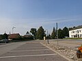 Räpina centre
 -
 Räpina paper mill
 -
 Räpina manor
 -
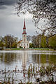 Räpina church
 -
 Räpina Lake
 -
 Räpina harbour on Lake Peipus


.JPG)

Notable people
- Paul Haavaoks (1924-1983), poet and writer
- Aapo Ilves (born 1970), poet, writer, artist and musician
References
External links
- Räpina Parish (in Estonian)
| ||
Jaanilinn (Ivangorod) and Petseri (Pechory) were annexed by the Soviet Union in 1945 and are currently part of Russia. | ||

This Põlva County location article is a stub. You can help Wikipedia by expanding it. |