Osov (Beroun District): Difference between revisions
Appearance
Content deleted Content added
update coords format in infobox |
m →References: add authority control |
||
| Line 84: | Line 84: | ||
{{coord|49|51|N|14|05|E|display=title|region:CZ_type:city_source:GNS-enwiki}} |
{{coord|49|51|N|14|05|E|display=title|region:CZ_type:city_source:GNS-enwiki}} |
||
{{authority control}} |
|||
[[Category:Villages in the Beroun District]] |
[[Category:Villages in the Beroun District]] |
||
Revision as of 03:48, 1 April 2020
You can help expand this article with text translated from the corresponding article in Czech. (July 2009) Click [show] for important translation instructions.
|
Osov | |
|---|---|
Municipality and village | |
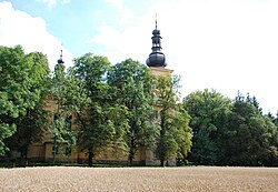
 Church of John the Baptist, Osov | |
 | |
| Land | |
| Region | Central Bohemian Region |
| District | Beroun District |
| Area | |
| • Total | 0.95 sq mi (2.45 km2) |
| Elevation | 1,198 ft (365 m) |
| Population (1.1.2013) | |
| • Total | 343 |
| • Density | 360/sq mi (140/km2) |
| Time zone | UTC+1 (CET) |
| • Summer (DST) | UTC+2 (CEST) |
Osov is a municipality and village in Beroun District in the Central Bohemian Region of the Czech Republic.
References
- This article was initially translated from the Czech Wikipedia.
Wikimedia Commons has media related to Osov.
49°51′N 14°05′E / 49.850°N 14.083°E


