
Pinkuylluna: Difference between revisions
Content deleted Content added
added stub template |
|||
| Line 54: | Line 54: | ||
{{reflist}} |
{{reflist}} |
||
{{Archaeological sites in Peru}} |
{{Archaeological sites in Peru}}{{Peru-geo-stub}}{{Peru-hist-stub}}{{SouthAm-archaeology-stub}} |
||
[[Category:Archaeological sites in Peru]] |
[[Category:Archaeological sites in Peru]] |
||
[[Category:Mountains of Peru]] |
[[Category:Mountains of Peru]] |
||
Revision as of 18:07, 13 April 2020
 The site Pinkuylluna | |
| Location | Peru |
|---|---|
| Region | Cusco Region |
| Coordinates | 13°15′22″S 72°15′40″W / 13.25611°S 72.26111°W |
| History | |
| Cultures | Inca |
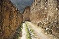
Pinkuylluna[1] or Pinkulluna (Quechua, Hispanicized spellings Pincuylluna, Pinculluna) is an archaeological site on a mountain of the same name in Peru located in the Cusco Region, Urubamba Province, Ollantaytambo District. It is situated between the rivers Patakancha (Patacancha) and Willkanuta, northeast of the town Ollantaytambo.[2]
Gallery
-
 Pinkuylluna ruins
 -
 The mountain Pinkuylluna (on the right) above the town Ollantaytambo. A huge face of stone is visible beside the Pinkuylluna ruins.
 -
 Interior of the central store room.


See also
References and notes
- ^ mincetur.gob.pe Sitio Arqueológico de Pinkuylluna (in Spanish)
- ^ escale.minedu.gob.pe - UGEL map of the Urubamba Province (Cusco Region) showing the location of the mountain Pinkuylluna (Pinculluna)
This Peruvian geography article is a stub. You can help Wikipedia by expanding it. |
This article about the history of Peru is a stub. You can help Wikipedia by expanding it. |
This South American archaeology article is a stub. You can help Wikipedia by expanding it. |