
Chappal Waddi: Difference between revisions
Content deleted Content added
Adding customary units Tags: Mobile edit Mobile web edit Advanced mobile edit |
|||
| Line 21: | Line 21: | ||
}} |
}} |
||
'''Chappal Waddi''' is a mountain in [[Nigeria]] and, at 2,419 |
'''Chappal Waddi''' is a mountain in [[Nigeria]] and, at {{convert|2,419|m|ft|abbr=on}}, is the country's highest point.<ref>http://www.freeworldmaps.net/africa/nigeria/map.html Physical Map of Nigeria |
||
</ref> It is located in [[Taraba State]], near the border with [[Cameroon]], in the Gashaka Gumti Forest Reserve and [[Gashaka-Gumti National Park]] on the [[Mambilla Plateau]].<ref>http://www.nigeria-direct.com/activity/climb-nigeria's-highest-mountain-chappal-waddi{{Dead link|date=November 2019 |bot=InternetArchiveBot |fix-attempted=yes }}</ref> it is a part of the Bamenda-Adamawa-Mandara Mountain chain of Nigeria and Cameroon. |
</ref> It is located in [[Taraba State]], near the border with [[Cameroon]], in the Gashaka Gumti Forest Reserve and [[Gashaka-Gumti National Park]] on the [[Mambilla Plateau]].<ref>http://www.nigeria-direct.com/activity/climb-nigeria's-highest-mountain-chappal-waddi{{Dead link|date=November 2019 |bot=InternetArchiveBot |fix-attempted=yes }}</ref> it is a part of the Bamenda-Adamawa-Mandara Mountain chain of Nigeria and Cameroon. |
||
== Gallery == |
== Gallery == |
||
Revision as of 21:25, 21 October 2020
| Chappal Waddi | |
|---|---|
 Adventure to Chappal Wadi | |
| Highest point | |
| Elevation | 2,419 m (7,936 ft)[1] |
| Listing | Country high point |
| Coordinates | 07°02′10″N 11°42′54″E / 7.03611°N 11.71500°E |
| Geography | |
 Chappal Waddi Location of Chappal Waddi in Nigeria (on border with Cameroon) | |
| Standort | Nigeria / Cameroon |
Chappal Waddi is a mountain in Nigeria and, at 2,419 m (7,936 ft), is the country's highest point.[2] It is located in Taraba State, near the border with Cameroon, in the Gashaka Gumti Forest Reserve and Gashaka-Gumti National Park on the Mambilla Plateau.[3] it is a part of the Bamenda-Adamawa-Mandara Mountain chain of Nigeria and Cameroon.
Gallery
-
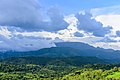 Chappal Wadi, second highest point in sub-saharan West Africa after Mt Cameroun and Emi Koussi
 -
 Dusk in a remote section of Gashaka-Gumti National Park
 -
 Boundary along the Nigerian-Cameroun border in Gashaka-Gumti National Park


References
This Taraba State, Nigeria location article is a stub. You can help Wikipedia by expanding it. |