
Abingdon railway station: Difference between revisions
m Added internal links to Infobox. Tags: Visual edit Mobile edit Mobile web edit Advanced mobile edit |
m Added BFI template external link (test). Tags: Reverted Visual edit Mobile edit Mobile web edit Advanced mobile edit |
||
| Line 54: | Line 54: | ||
==External links== |
==External links== |
||
* [http://www.npemap.org.uk/tiles/map.html#449,197,1 Station on navigable O.S. map] |
* [http://www.npemap.org.uk/tiles/map.html#449,197,1 Station on navigable O.S. map] |
||
* {{BFI | id=15383 | title=High, Wide and Faster}} |
|||
* [http://www.subbrit.org.uk/sb-sites/stations/a/abingdon/index.shtml Sub Brit site] |
* [http://www.subbrit.org.uk/sb-sites/stations/a/abingdon/index.shtml Sub Brit site] |
||
* [http://www.abingdonbranch.co.uk GWR Abingdon Branch] |
* [http://www.abingdonbranch.co.uk GWR Abingdon Branch] |
||
Revision as of 17:33, 7 January 2021
Abingdon | |
|---|---|
 Abingdon 1970 - brewery maltings to right | |
| General information | |
| Standort | Abingdon, Vale of White Horse England |
| Coordinates | 51°40′20″N 1°16′48″W / 51.67223°N 1.28009°W |
| Grid reference | SU499973 |
| Platforms | 1 |
| Other information | |
| Status | Disused |
| History | |
| Opened | 2 June 1856 [1] |
| Closed | 9 September 1963 (Passengers); June 1984 (Goods) |
| Original company | Abingdon Railway |
| Pre-grouping | Great Western Railway |
| Post-grouping | GWR |
| Key dates | |
| November 1872 | Converted from broad to standard gauge. |
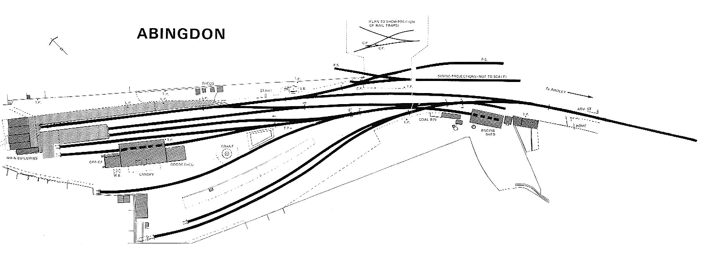
Abingdon railway station was a station which until 1963 served the town of Abingdon, then in Berkshire, now in Oxfordshire, in England.
History
.JPG)
The station was built by the Abingdon Railway, although this was operated by the Great Western Railway (GWR) from opening on 2 June 1856. The station and yard were built to the broad gauge on land acquired from the Mayor and Aldermen of the Borough of Abingdon on 19 March 1856 at a cost of £472. Seven properties were demolished to make way for the station and yard, including the Plough Inn which was subsequently rebuilt at a different location. The approach to the station from Stert Street had gates and no public right of way was allowed.[2] Station facilities consisted of a single platform covered by a timber train shed.[2] A locomotive shed was built on land which was never formally conveyed to the railway, but later acquired by adverse possession.[2]
The Abingdon Railway was absorbed by the GWR on 15 August 1904.[3] The line passed on to the Western Region of British Railways on nationalisation in 1948, and was then closed to passengers by the British Railways Board in 1963. The station was briefly featured in the Look At Life film High, Wide and Faster. However the branch was used by freight, notably MG Cars, and the occasional passenger excursion, the last of which took place in June 1984.
The branch track was lifted in the late 1980s. A fraction of the former railway line is now used for a cyclepath, while the station and the adjoining part of the line near the town centre have been overbuilt by a supermarket, parking and other development.
Routes
| Preceding station | Disused railways | Following station | ||
|---|---|---|---|---|
| Abingdon Junction Station closed; Line open before 1872 |
Abingdon Railway Great Western Railway |
Terminus | ||
| Radley Station open; Line open after 1872 |
Abingdon Railway Great Western Railway |
Notes
- ^ "Opening of the Abingdon Station". Reading Mercury, Oxford Gazette, Newbury Herald, and Berks County Advertiser. 31 May 1856. p. 7.
- ^ a b c Trippett & de Courtais 1985, p. 5.
- ^ "Railway Companies acquired by the GWR". Retrieved 15 April 2009.
Sources
- Butt, R. V. J. (October 1995). The Directory of Railway Stations: details every public and private passenger station, halt, platform and stopping place, past and present (1st ed.). Sparkford: Patrick Stephens Ltd. ISBN 978-1-85260-508-7. OCLC 60251199. OL 11956311M.
- Jowett, Alan (2000). Jowett's Nationalised Railway Atlas (1st ed.). Penryn, Cornwall: Atlantic Transport Publishers. ISBN 978-0-906899-99-1. OCLC 228266687.
- Trippett, Nigel; de Courtais, Nicholas (1985). The Abingdon Branch. Upper Bucklebury, Berks.: Wild Swan Publications Ltd. ISBN 0-906867-29-0.
{{cite book}}: Invalid|ref=harv(help)