
Wayland's Smithy: Difference between revisions
Citation bot (talk | contribs) Alter: title. Add: s2cid. | You can use this bot yourself. Report bugs here. | Suggested by Abductive | Category:Stone Age sites in England | via #UCB_Category 61/95 |
Dave.Dunford (talk | contribs) scheduled monument, infobox and other minor c/e |
||
| Line 1: | Line 1: | ||
{{Use dmy dates|date=January 2021}} |
|||
{{short description|Neolithic long barrow and chamber tomb site in Oxfordshire, England}} |
{{short description|Neolithic long barrow and chamber tomb site in Oxfordshire, England}} |
||
{{Infobox ancient site |
{{Infobox ancient site |
||
| Line 19: | Line 20: | ||
|public_access = Yes |
|public_access = Yes |
||
|condition = Restored |
|condition = Restored |
||
|excavations = |
|excavations = 1962–63 |
||
|archaeologists = [[Stuart Piggott]] |
|archaeologists = [[Stuart Piggott]] |
||
|website = [https://www.english-heritage.org.uk/visit/places/waylands-smithy/ English Heritage] |
|website = [https://www.english-heritage.org.uk/visit/places/waylands-smithy/ English Heritage] |
||
|designation1 = Scheduled monument |
|designation1 = Scheduled monument |
||
|designation1_number = 1008409 |
|||
|designation1_number = PRN7306<ref>[http://publicapps.oxfordshire.gov.uk/wps/portal/publicapps/applications/heritage Museums and Archaeology - Oxfordshire Historic Environment Record]</ref> |
|||
|designation1_offname = Wayland's Smithy chambered long barrow, including an earlier barrow and Iron Age and Roman boundary ditches |
|||
|designation1_date = 1882 <ref>{{cite wikisource |last=Hunter |first=Robert |chapter=Appendix A |wslink=The Preservation of Places of Interest or Beauty |plaintitle=The Preservation of Places of Interest or Beauty |year=1907 |publisher=Manchester University Press}}</ref> |
|designation1_date = 1882<ref name="NHLE">{{NHLE |num=1008409 |desc=Wayland's Smithy chambered long barrow, including an earlier barrow and Iron Age and Roman boundary ditches |accessdate=12 January 2012}}</ref><ref>{{cite wikisource |last=Hunter |first=Robert |chapter=Appendix A |wslink=The Preservation of Places of Interest or Beauty |plaintitle=The Preservation of Places of Interest or Beauty |year=1907 |publisher=Manchester University Press}}</ref> |
||
}} |
}} |
||
'''Wayland's Smithy''' is a [[chambered long barrow]] located near the village of [[Ashbury, Oxfordshire|Ashbury]] in the [[South East England|south-eastern]] [[England|English]] county of [[Oxfordshire]]. Probably constructed in the |
'''Wayland's Smithy''' is a [[chambered long barrow]] located near the village of [[Ashbury, Oxfordshire|Ashbury]] in the [[South East England|south-eastern]] [[England|English]] county of [[Oxfordshire]]. Probably constructed in the thirty-sixth century [[Anno Domini|BC]], during Britain's [[Neolithic British Isles|Early Neolithic]] period, today it survives in a partially reconstructed state. |
||
[[Archaeology|Archaeologists]] have established that the monument was built by [[pastoralism|pastoralist]] communities shortly after the introduction of [[agriculture]] to Britain from continental Europe. Although representing part of an architectural tradition of long barrow building that was widespread across Neolithic Europe, Wayland's Smithy belongs to a localised regional variant of barrows produced in the south-west of Britain, now known as the [[Severn-Cotswold tomb|Severn-Cotswold group]]. Of these, it is in one of the best surviving conditions. |
[[Archaeology|Archaeologists]] have established that the monument was built by [[pastoralism|pastoralist]] communities shortly after the introduction of [[agriculture]] to Britain from continental Europe. Although representing part of an architectural tradition of long barrow building that was widespread across Neolithic Europe, Wayland's Smithy belongs to a localised regional variant of barrows produced in the south-west of Britain, now known as the [[Severn-Cotswold tomb|Severn-Cotswold group]]. Of these, it is in one of the best surviving conditions. |
||
| Line 33: | Line 35: | ||
The later mound was {{convert|185|ft}} long and {{convert|43|ft}} wide at the south end. Its present appearance is the result of restoration following excavations undertaken by [[Stuart Piggott]] and [[Richard J. C. Atkinson|Richard Atkinson]] in 1962–63. They demonstrated that the site had been built in two different phases, a timber-chambered [[oval barrow]] built around 3590 and 3550 BC and a later stone-chambered long barrow in around 3460 to 3400 BC.<ref name=EH>{{cite web|url=http://www.english-heritage.org.uk/daysout/properties/waylands-smithy/history-and-research/|title=Archaeological history and research|publisher=English Heritage|accessdate=27 June 2014|url-status=dead|archive-url=https://web.archive.org/web/20140107041032/http://www.english-heritage.org.uk/daysout/properties/waylands-smithy/history-and-research/|archive-date=7 January 2014}}</ref> |
The later mound was {{convert|185|ft}} long and {{convert|43|ft}} wide at the south end. Its present appearance is the result of restoration following excavations undertaken by [[Stuart Piggott]] and [[Richard J. C. Atkinson|Richard Atkinson]] in 1962–63. They demonstrated that the site had been built in two different phases, a timber-chambered [[oval barrow]] built around 3590 and 3550 BC and a later stone-chambered long barrow in around 3460 to 3400 BC.<ref name=EH>{{cite web|url=http://www.english-heritage.org.uk/daysout/properties/waylands-smithy/history-and-research/|title=Archaeological history and research|publisher=English Heritage|accessdate=27 June 2014|url-status=dead|archive-url=https://web.archive.org/web/20140107041032/http://www.english-heritage.org.uk/daysout/properties/waylands-smithy/history-and-research/|archive-date=7 January 2014}}</ref> |
||
Wayland's Smithy is along the same hill as the [[Uffington White Horse]] and [[Uffington Castle]], while it is also close to [[The Ridgeway]], an ancient road running along the [[Berkshire Downs]]. In the [[Early medieval England|early middle ages]], the site became associated with the mythological figure [[Wayland the Smith]], from which it gained its name. Since the late 20th century it has been used as a ritual site by various [[Modern Paganism|modern Pagan]] groups. Now under the guardianship of the [[English Heritage]], it is open without charge to visitors all year round. |
Wayland's Smithy is along the same hill as the [[Uffington White Horse]] and [[Uffington Castle]], while it is also close to [[The Ridgeway]], an ancient road running along the [[Berkshire Downs]]. In the [[Early medieval England|early middle ages]], the site became associated with the mythological figure [[Wayland the Smith]], from which it gained its name. Since the late 20th century it has been used as a ritual site by various [[Modern Paganism|modern Pagan]] groups. Now under the guardianship of the [[English Heritage]] and designated as a [[scheduled monument]],<ref name="NHLE" /> it is open without charge to visitors all year round. |
||
==Context== |
==Context== |
||
| Line 39: | Line 41: | ||
[[Image:RidgewayRingfort.jpg|left|thumb|The Ridgeway (Uffington Castle ringfort in the distance, on the left)]] |
[[Image:RidgewayRingfort.jpg|left|thumb|The Ridgeway (Uffington Castle ringfort in the distance, on the left)]] |
||
The Early Neolithic was a revolutionary period of British history. Between 4500 and 3800 BC, it saw a widespread change in lifestyle as the communities living in the [[British Isles]] adopted [[agriculture]] as their primary form of subsistence, abandoning the [[hunter-gatherer]] lifestyle that had characterised the preceding [[Mesolithic]] period.{{sfn|Hutton|1991|pp=16–17}} This came about through contact with continental societies, although it is unclear to what extent this can be attributed to an influx of migrants or to indigenous Mesolithic Britons adopting agricultural technologies from the continent.{{sfnm|1a1=Hutton|1y=1991|1p=16|2a1=Ashbee|2y=1999|2p=272|3a1=Hutton|3y=2013|3pp= |
The Early Neolithic was a revolutionary period of British history. Between 4500 and 3800 BC, it saw a widespread change in lifestyle as the communities living in the [[British Isles]] adopted [[agriculture]] as their primary form of subsistence, abandoning the [[hunter-gatherer]] lifestyle that had characterised the preceding [[Mesolithic]] period.{{sfn|Hutton|1991|pp=16–17}} This came about through contact with continental societies, although it is unclear to what extent this can be attributed to an influx of migrants or to indigenous Mesolithic Britons adopting agricultural technologies from the continent.{{sfnm|1a1=Hutton|1y=1991|1p=16|2a1=Ashbee|2y=1999|2p=272|3a1=Hutton|3y=2013|3pp=34–35}} |
||
==Site description== |
==Site description== |
||
The wooden mortuary house mainly consisted of a paved stone floor with two large posts at either end. A single crouched burial had been placed at one end and, the mostly disarticulated remains of a further 14 individuals were scattered in front of it.<ref name=EH/> Analysis of these remains indicated that they had been subjected to [[excarnation]] before burial and deposited in possibly four different phases. [[Posthole]]s at one end have been interpreted as supporting a timber facade. An earth barrow covered the whole monument with material excavated from two flanking ditches and measured around {{convert|15|ft}} wide and {{convert|6|ft}} deep.<ref>{{cite web|url=https://www.silentearth.org/waylands-smithy/|title=Wayland's Smithy|date=12 August 2016|author= Austin Kinsley|website=www.silentearth.org}}</ref><ref>{{cite journal|last1=Atkinson|first1=R. J. C.|title=Wayland's Smithy|journal=Antiquity|volume=39|issue=154|year=1965|pages=126–133|issn=0003-598X|doi=10.1017/S0003598X00031653}}</ref> |
The wooden mortuary house mainly consisted of a paved stone floor with two large posts at either end. A single crouched burial had been placed at one end and, the mostly disarticulated remains of a further 14 individuals were scattered in front of it.<ref name=EH/> Analysis of these remains indicated that they had been subjected to [[excarnation]] before burial and deposited in possibly four different phases. [[Posthole]]s at one end have been interpreted as supporting a timber facade. An earth barrow covered the whole monument with material excavated from two flanking ditches and measured around {{convert|15|ft}} wide and {{convert|6|ft}} deep.<ref>{{cite web|url=https://www.silentearth.org/waylands-smithy/|title=Wayland's Smithy|date=12 August 2016|author= Austin Kinsley|website=www.silentearth.org}}</ref><ref>{{cite journal|last1=Atkinson|first1=R. J. C.|title=Wayland's Smithy|journal=Antiquity|volume=39|issue=154|year=1965|pages=126–133|issn=0003-598X|doi=10.1017/S0003598X00031653}}</ref> |
||
The later stone tomb consists of two opposing transept chambers and terminal chamber; along with the longer entrance chamber, this gives the burial area a cruciform appearance in plan. At the entrance four large [[sarsen]] stones stand (originally six, but two are lost), having been returned to their upright locations following the 1962 excavations.<ref>[http://www.pegasusarchive.org/ancientbritain/waylands_smithy.htm Ancient Britain |
The later stone tomb consists of two opposing transept chambers and terminal chamber; along with the longer entrance chamber, this gives the burial area a cruciform appearance in plan. At the entrance four large [[sarsen]] stones stand (originally six, but two are lost), having been returned to their upright locations following the 1962 excavations.<ref>[http://www.pegasusarchive.org/ancientbritain/waylands_smithy.htm Ancient Britain – Wayland's Smithy]</ref> It is classified by [[archaeologist]]s as one of the [[Severn-Cotswold tomb]]s. The large trapezoidal earth [[tumulus|barrow]] erected over it was revetted with a stone [[Megalithic architectural elements|kerb]] and its material was again excavated from two large flanking ditches. Excavation in 1919 revealed the jumbled remains of seven adults and one child.<ref name=EH2>[http://www.english-heritage.org.uk/daysout/properties/waylands-smithy/history-and-research/waylands-smithy-ii/ history and research: Waylands Smithy II. English Heritage], accessed 27 June 2014</ref> |
||
The site is important as it illustrates a transition from a timber-chambered barrow to stone-chamber tomb over a period that may have been as short as 50 years. Carbon dating of the burials in the second tomb suggests it was a late use of this style of burial, being similar to [[West Kennet Long Barrow]], which had been in use 200 years before.<ref name=EH2/> |
The site is important as it illustrates a transition from a timber-chambered barrow to stone-chamber tomb over a period that may have been as short as 50 years. Carbon dating of the burials in the second tomb suggests it was a late use of this style of burial, being similar to [[West Kennet Long Barrow]], which had been in use 200 years before.<ref name=EH2/> |
||
| Line 98: | Line 100: | ||
===Bibliography=== |
===Bibliography=== |
||
{{Refbegin|30em|indent=yes}} |
{{Refbegin|30em|indent=yes}} |
||
* {{cite journal |last=Ashbee |first=Paul |title=The Medway Megaliths in a European Context |journal=Archaeologia Cantiana |publisher=Kent Archaeological Society |volume=119 |year=1999 |pages= |
* {{cite journal |last=Ashbee |first=Paul |title=The Medway Megaliths in a European Context |journal=Archaeologia Cantiana |publisher=Kent Archaeological Society |volume=119 |year=1999 |pages=269–284 |url=http://www.kentarchaeology.org.uk/Research/Pub/ArchCant/119-1999/119-09.pdf }} |
||
* {{cite web |author=BBC News |title=Wayland's Smithy 'neo-Nazi ritual' reports spark more patrols |website=BBC News |date=11 August 2019 |url=https://www.bbc.co.uk/news/uk-england-oxfordshire-49313179 |accessdate=27 August 2019 }} |
* {{cite web |author=BBC News |title=Wayland's Smithy 'neo-Nazi ritual' reports spark more patrols |website=BBC News |date=11 August 2019 |url=https://www.bbc.co.uk/news/uk-england-oxfordshire-49313179 |accessdate=27 August 2019 }} |
||
* {{cite book |last=Bramwell |first=Peter |year=2009 |title=Pagan Themes in Modern Children's Fiction: Green Man, Shamanism, Earth Mysteries |publisher=Palgrave Macmillan |location=New York |isbn=978-0-230-21839-0 }} |
* {{cite book |last=Bramwell |first=Peter |year=2009 |title=Pagan Themes in Modern Children's Fiction: Green Man, Shamanism, Earth Mysteries |publisher=Palgrave Macmillan |location=New York |isbn=978-0-230-21839-0 }} |
||
| Line 127: | Line 129: | ||
[[Category:Stone Age sites in England]] |
[[Category:Stone Age sites in England]] |
||
[[Category:Archaeological sites in Oxfordshire]] |
[[Category:Archaeological sites in Oxfordshire]] |
||
[[Category:Scheduled Ancient Monuments in Oxfordshire]] |
|||
[[Category:Oxfordshire folklore]] |
[[Category:Oxfordshire folklore]] |
||
[[Category:Berkshire folklore]] |
[[Category:Berkshire folklore]] |
||
Revision as of 12:00, 12 January 2021
 The long barrow entrance | |
 | |
 Map showing location in Oxfordshire | |
| Standort | Near Ashbury |
|---|---|
| Region | Oxfordshire England |
| Coordinates | 51°34′00″N 1°35′46″W / 51.5667811°N 1.5961466°W |
| Typ | long barrow and chamber tomb |
| History | |
| Periods | Neolithic |
| Site notes | |
| Excavation dates | 1962–63 |
| Archaeologists | Stuart Piggott |
| Condition | Restored |
| Public access | Yes |
| Website | English Heritage |
| Official name | Wayland's Smithy chambered long barrow, including an earlier barrow and Iron Age and Roman boundary ditches |
| Designated | 1882[1][2] |
| Reference no. | 1008409 |
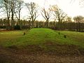
Wayland's Smithy is a chambered long barrow located near the village of Ashbury in the south-eastern English county of Oxfordshire. Probably constructed in the thirty-sixth century BC, during Britain's Early Neolithic period, today it survives in a partially reconstructed state.
Archaeologists have established that the monument was built by pastoralist communities shortly after the introduction of agriculture to Britain from continental Europe. Although representing part of an architectural tradition of long barrow building that was widespread across Neolithic Europe, Wayland's Smithy belongs to a localised regional variant of barrows produced in the south-west of Britain, now known as the Severn-Cotswold group. Of these, it is in one of the best surviving conditions.
The later mound was 185 feet (56 m) long and 43 feet (13 m) wide at the south end. Its present appearance is the result of restoration following excavations undertaken by Stuart Piggott and Richard Atkinson in 1962–63. They demonstrated that the site had been built in two different phases, a timber-chambered oval barrow built around 3590 and 3550 BC and a later stone-chambered long barrow in around 3460 to 3400 BC.[3]
Wayland's Smithy is along the same hill as the Uffington White Horse and Uffington Castle, while it is also close to The Ridgeway, an ancient road running along the Berkshire Downs. In the early middle ages, the site became associated with the mythological figure Wayland the Smith, from which it gained its name. Since the late 20th century it has been used as a ritual site by various modern Pagan groups. Now under the guardianship of the English Heritage and designated as a scheduled monument,[1] it is open without charge to visitors all year round.
Context

The Early Neolithic was a revolutionary period of British history. Between 4500 and 3800 BC, it saw a widespread change in lifestyle as the communities living in the British Isles adopted agriculture as their primary form of subsistence, abandoning the hunter-gatherer lifestyle that had characterised the preceding Mesolithic period.[4] This came about through contact with continental societies, although it is unclear to what extent this can be attributed to an influx of migrants or to indigenous Mesolithic Britons adopting agricultural technologies from the continent.[5]
Site description
The wooden mortuary house mainly consisted of a paved stone floor with two large posts at either end. A single crouched burial had been placed at one end and, the mostly disarticulated remains of a further 14 individuals were scattered in front of it.[3] Analysis of these remains indicated that they had been subjected to excarnation before burial and deposited in possibly four different phases. Postholes at one end have been interpreted as supporting a timber facade. An earth barrow covered the whole monument with material excavated from two flanking ditches and measured around 15 feet (4.6 m) wide and 6 feet (1.8 m) deep.[6][7]
The later stone tomb consists of two opposing transept chambers and terminal chamber; along with the longer entrance chamber, this gives the burial area a cruciform appearance in plan. At the entrance four large sarsen stones stand (originally six, but two are lost), having been returned to their upright locations following the 1962 excavations.[8] It is classified by archaeologists as one of the Severn-Cotswold tombs. The large trapezoidal earth barrow erected over it was revetted with a stone kerb and its material was again excavated from two large flanking ditches. Excavation in 1919 revealed the jumbled remains of seven adults and one child.[9]
The site is important as it illustrates a transition from a timber-chambered barrow to stone-chamber tomb over a period that may have been as short as 50 years. Carbon dating of the burials in the second tomb suggests it was a late use of this style of burial, being similar to West Kennet Long Barrow, which had been in use 200 years before.[9]
Wayland's Smithy is one of many prehistoric sites associated with Wayland or Wolund, a Germanic smith-god. The name was seemingly applied to the site by the Saxons who settled in the area some four thousand years after Wayland's Smithy was built. The first documented use of the name was in 955 AD, in a Saxon charter of King Eadred.[10]
Folklore, folk tradition, and modern Paganism

The name "Wayland's Smithy" is a reference to the mythological metal-worker Wayland the Smith. This character appears in Norse mythology, and a depiction of him is believed to be present on the Franks Casket, on display in the British Museum in London.[11] The monument's name is first recorded in an early medieval land charter (BCS 908) from Compton Beauchamp, which has been attributed a date of 955 AD.[12]
In 1738, Francis Wise, who was then the under-keeper of the Bodleian Library, recorded a belief held about the site in local folklore.[13] Like several other early commentators, Wise referred to the site not as "Wayland's Smithy", but only as "Wayland Smith".[14] Wise related that:
- All the account which the country people are able to give of it is 'At this place lived formerly an invisible Smith, and if a traveller's Horse had lost a Shoe upon the road, he had no more to do than to bring the Horse to this place with a piece of money, and leaving both there for some little time, he might come again and find the money gone, but the Horse new shod.[15]
The site was also mentioned in a letter sent to the antiquarian William Stukeley by his daughter Anna on 3 October 1758.[16] There is some folklore associating witch relics with the site.[16] It is referred to as "Wayland Smith's Forge" in Walter Scott's 1821 novel Kenilworth.[16] In 1828, a one-inch Ordnance Survey map recorded the site's name as being "Wayland Smith's Forge". The folklorist and archaeologist Leslie Grinsell suggested that the decision to name it this on the map was influenced by Scott's novel.[16]
Twentieth and twenty-first century activity
The deposition of coins at the site has taken place since at least the 1960s, with visitors lodging the coins into cracks in the site's stones.[17] As of 2015, the local wardens from The National Trust are tasked with removing said deposits, and circa 2010 English Heritage removed information about the coin deposition custom from the site's information panel.[17] The coins removed by the wardens are then donated to local charities.[18] As the folklorist Ceri Houlbrook noted, all of this deposited material "contributes to the ritual narrative of a site".[19] Graffiti carved into the trees around the site have included swastikas.[20]
Among the modern Pagan groups that use Wayland's Smithy for ritual purposes have been various Druids. The anthropologist Thorsten Gieser noted that the site was important to Druids because of its folkloric links to Wayland and because of its use as a prehistoric burial ground. These Druids regard it as a space in which to communicate with "ancestors", "spirits of the earth", and an "earth goddess".[21] In 2019, various press sources expressed concern that one of the Pagan groups using the site for their nocturnal rituals was Woden's Folk, a Heathen group which held to neo-Nazi views. The National Trust responded that they would increase the number of times that their rangers visited the site.[20]
Cultural references
Walter Scott's Elizabethan novel Kenilworth (published 1821) features both the stone chambered tomb and a character named 'Wayland Smith'.[10]
Susan Cooper's The Dark is Rising series of young-adult novels features a supporting character named Wayland Smith, and deals greatly with English lore and legend.
Julian Cope included a song called "Wayland's Smithy Has Wings" on his 1992 album The Skellington Chronicles.[citation needed]
Author Patricia Kennealy-Morrison has a protagonist named Turk Wayland in her Rennie Stride mystery series, and sets a scene at the end of the fourth book, A Hard Slay's Night: Murder at the Royal Albert Hall, at Wayland's Smithy.[citation needed]
Rudyard Kipling, in his interlinked collection of stories Puck of Pook's Hill, set many of the stories near the Smithy, and told of the arrival of the smith god in the first.[citation needed]
Both the Uffington White Horse and Wayland's Smithy were incorporated into the BBC miniseries The Moon Stallion, produced in 1978. In the serial, set in 1906, the stones are associated with witchcraft.[22]
The British music group Radiohead recorded a music video here for their non-album single "Pop Is Dead".[citation needed]
-
 Wayland's Smithy, tomb (detail)
 -
 The entrance
 -
 Side view
 -
 Side view at dusk
 -
 The top of the tomb


References
Footnotes
- ^ a b Historic England. "Wayland's Smithy chambered long barrow, including an earlier barrow and Iron Age and Roman boundary ditches (1008409)". National Heritage List for England. Retrieved 12 January 2012.
- ^ Hunter, Robert (1907). . The Preservation of Places of Interest or Beauty. Manchester University Press – via Wikisource.
- ^ a b "Archaeological history and research". English Heritage. Archived from the original on 7 January 2014. Retrieved 27 June 2014.
- ^ Hutton 1991, pp. 16–17.
- ^ Hutton 1991, p. 16; Ashbee 1999, p. 272; Hutton 2013, pp. 34–35.
- ^ Austin Kinsley (12 August 2016). "Wayland's Smithy". www.silentearth.org.
- ^ Atkinson, R. J. C. (1965). "Wayland's Smithy". Antiquity. 39 (154): 126–133. doi:10.1017/S0003598X00031653. ISSN 0003-598X.
- ^ Ancient Britain – Wayland's Smithy
- ^ a b history and research: Waylands Smithy II. English Heritage, accessed 27 June 2014
- ^ a b berkshirehistory.com/waylands_smithy, David Nash Ford, 2003. Accessed 27 June 2014
- ^ Grinsell 1976, p. 46.
- ^ Grinsell 1976, pp. 46, 149.
- ^ Ellis Davidson 1958, p. 146; Grinsell 1976, p. 149.
- ^ Ellis Davidson 1958, p. 147.
- ^ Ellis Davidson 1958, pp. 146–147.
- ^ a b c d Grinsell 1976, p. 149.
- ^ a b Houlbrook 2015, p. 178.
- ^ Houlbrook 2015, p. 182.
- ^ Houlbrook 2015, p. 184.
- ^ a b Dixon 2019; BBC News 2019.
- ^ Gieser 2016, p. 55.
- ^ Bramwell 2009, pp. 167, 173–174.
Bibliography
- Ashbee, Paul (1999). "The Medway Megaliths in a European Context" (PDF). Archaeologia Cantiana. 119. Kent Archaeological Society: 269–284.
- BBC News (11 August 2019). "Wayland's Smithy 'neo-Nazi ritual' reports spark more patrols". BBC News. Retrieved 27 August 2019.
- Bramwell, Peter (2009). Pagan Themes in Modern Children's Fiction: Green Man, Shamanism, Earth Mysteries. New York: Palgrave Macmillan. ISBN 978-0-230-21839-0.
- Dixon, Hayley (9 August 2019). "Neo-Nazis at the National Trust: How far-right groups are trying to 'take back' ancient sites". The Telegraph. Retrieved 27 August 2019.
- Ellis Davidson, Hilda R. (1958). "Weland the Smith". Folklore. 69 (3): 145–59. doi:10.1080/0015587X.1958.9717140. JSTOR 1258855.
- Gieser, Thorsten (2016). "Druids at Wayland's Smithy: Tracing Transformations of the Sentient Body in Ritual". In Matthias Jung; Michaela Bauks; Andreas Ackermann (eds.). Dem Körper eingeschrieben: Verkörperung zwischen Leiberleben und kulturellem Sinn. New York: Springer. pp. 55–72.
- Grinsell, Leslie V. (1976). Folklore of Prehistoric Sites in Britain. London: David & Charles. ISBN 0-7153-7241-6.
- Grinsell, Leslie V. (1979). "Notes on the Folklore of Prehistoric Sites in Britain". Folklore. 90 (1): 66–70. doi:10.1080/0015587X.1979.9716124.
- Houlbrook, Ceri (2015). "The Penny's Dropped: Renegotiating the Contemporary Coin Deposit". Journal of Material Culture. 20 (2): 173–189. doi:10.1177/1359183515577120. hdl:2299/18964. S2CID 159495735.
- Hutton, Ronald (1991). The Pagan Religions of the Ancient British Isles: Their Nature and Legacy. Oxford and Cambridge: Blackwell. ISBN 978-0-631-17288-8.
- Hutton, Ronald (2013). Pagan Britain. New Haven and London: Yale University Press. ISBN 978-0-300-197716.
External links
- Wayland's Smithy at the English Heritage website
- Wayland's Smithy at The Megalithic Portal
- Wayland's Smithy at The Modern Antiquarian