
Malminkartano
Malminkartano
Malmgård | |
|---|---|
 Position of Malminkartano within Helsinki | |
| Region | Uusimaa |
| Municipality | Helsinki |
| District | Western |
| Boroughs | List
|
| Area | 2.26 km2 (0.87 sq mi) |
| Postal codes | 00410 |
Malminkartano (Malmgård in Swedish[1]) is a suburb and a quarter in the western part of Helsinki city,[2] part of the Kaarela neighbourhood.[3] Vantaankosken rata, the railway of Vantaankoski, has a station in Malminkartano. The suburb's artificial hill, Malminkartanonhuippu or Malminkartanon täyttömäki is the highest point of Helsinki.[4] Malminkartano is often called Maltsu by young people.
Gallery
[edit]-
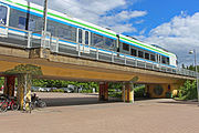 Malminkartano Railway Station
 -
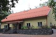 Malminkartano Chapel
 -
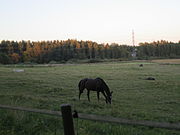 Malminkartano’s horse stable
 -
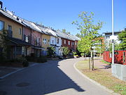 Houses in Malminkartano
 -
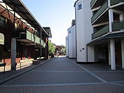 Street in Malminkartano


References
[edit]- ^ Hall, Thomas (1991). Planning and Urban Growth in the Nordic Countries. Taylor & Francis. p. 110. ISBN 978-0-419-16840-9. Retrieved 2009-03-08.
- ^ Altman, Irwin; Arzah Ts'erts'man; Arza Churchman (1994). Women and the Environment. Springer. p. 217. ISBN 978-0-306-44680-1. Retrieved 2009-03-08.
- ^ Helsingin piirijako. Helsingin kaupunki.
- ^ "My Helsinki". www.myhelsinki.fi. Retrieved 2019-02-09.
External links
[edit]![]() Media related to Malminkartano at Wikimedia Commons
Media related to Malminkartano at Wikimedia Commons

60°14′49″N 24°51′43″E / 60.24694°N 24.86194°E
This Southern Finland location article is a stub. You can help Wikipedia by expanding it. |