
Redfield, South Dakota
Redfield | |
|---|---|
| Redfield, South Dakota | |
| Motto: "...The Pheasant Capital Of The World!" | |
 Location in Spink County and the state of South Dakota | |
| Coordinates: 44°52′31″N 98°31′4″W / 44.87528°N 98.51778°W | |
| Country | United States |
| State | South Dakota |
| County | Spink |
| Incorporated | 1883[1] |
| Area | |
| • Total | 1.96 sq mi (5.08 km2) |
| • Land | 1.93 sq mi (4.99 km2) |
| • Water | 0.03 sq mi (0.09 km2) |
| Elevation | 1,302 ft (397 m) |
| Population | |
| • Total | 2,333 |
| • Estimate (2019)[4] | 2,273 |
| • Density | 1,179.55/sq mi (455.48/km2) |
| Time zone | UTC−6 (Central (CST)) |
| • Summer (DST) | UTC−5 (CDT) |
| ZIP code | 57469 |
| Area code | 605 |
| FIPS code | 46-53460 |
| GNIS feature ID | 1265687[5] |
| Website | City of Redfield |
Redfield is a city in and the county seat of Spink County, South Dakota, United States.[6] The population was 2,333 at the 2010 census. The city was named for J. B. Redfield, a railroad official.[7]
Geography
Redfield is located at 44°52′31″N 98°31′04″W / 44.875145°N 98.517850°W.[8]
According to the United States Census Bureau, the city has a total area of 1.92 square miles (4.97 km2), of which 1.89 square miles (4.90 km2) is land and 0.03 square miles (0.08 km2) is water.[9]
Redfield has been assigned the ZIP code 57469 and the FIPS place code 53460.
Climate
Redfield has a hot-summer humid continental climate (Köppen climate classification: Dwa). Summers can be hot and quite humid, but the winters are very cold with snowfall as early as October.
| Climate data for Redfield, South Dakota (1981–2010 normals, extremes 1949–present) | |||||||||||||
|---|---|---|---|---|---|---|---|---|---|---|---|---|---|
| Month | Jan | Feb | Mar | Apr | May | Jun | Jul | Aug | Sep | Oct | Nov | Dec | Year |
| Record high °F (°C) | 63 (17) |
72 (22) |
83 (28) |
98 (37) |
102 (39) |
110 (43) |
113 (45) |
104 (40) |
106 (41) |
97 (36) |
79 (26) |
69 (21) |
113 (45) |
| Mean daily maximum °F (°C) | 23.1 (−4.9) |
28.9 (−1.7) |
41.8 (5.4) |
58.0 (14.4) |
69.6 (20.9) |
78.6 (25.9) |
84.9 (29.4) |
83.7 (28.7) |
75.6 (24.2) |
59.7 (15.4) |
41.6 (5.3) |
27.5 (−2.5) |
56.1 (13.4) |
| Daily mean °F (°C) | 12.6 (−10.8) |
18.0 (−7.8) |
31.4 (−0.3) |
45.1 (7.3) |
57.0 (13.9) |
66.6 (19.2) |
72.3 (22.4) |
70.5 (21.4) |
60.1 (15.6) |
46.7 (8.2) |
30.6 (−0.8) |
17.5 (−8.1) |
44.0 (6.7) |
| Mean daily minimum °F (°C) | 1.9 (−16.7) |
7.4 (−13.7) |
20.7 (−6.3) |
32.3 (0.2) |
44.5 (6.9) |
53.7 (12.1) |
59.7 (15.4) |
57.2 (14.0) |
46.6 (8.1) |
33.5 (0.8) |
20.1 (−6.6) |
6.9 (−13.9) |
32.0 (0.0) |
| Record low °F (°C) | −38 (−39) |
−47 (−44) |
−26 (−32) |
−8 (−22) |
14 (−10) |
29 (−2) |
36 (2) |
31 (−1) |
16 (−9) |
7 (−14) |
−22 (−30) |
−36 (−38) |
−47 (−44) |
| Average precipitation inches (mm) | 0.34 (8.6) |
0.50 (13) |
1.11 (28) |
1.90 (48) |
3.17 (81) |
3.60 (91) |
3.45 (88) |
2.53 (64) |
2.40 (61) |
2.04 (52) |
0.56 (14) |
0.53 (13) |
22.13 (561.6) |
| Average snowfall inches (cm) | 6.2 (16) |
6.5 (17) |
7.7 (20) |
3.1 (7.9) |
trace | 0.0 (0.0) |
0.0 (0.0) |
0.0 (0.0) |
trace | 0.3 (0.76) |
4.6 (12) |
7.6 (19) |
36 (92.66) |
| Average precipitation days (≥ 0.01 in) | 4 | 4 | 6 | 7 | 10 | 10 | 8 | 7 | 7 | 6 | 4 | 4 | 77 |
| Average snowy days (≥ 0.1 in) | 4 | 3 | 3 | 1 | 0 | 0 | 0 | 0 | 0 | 0 | 2 | 4 | 17 |
Source: NOAA[10] Cite error: A <ref> tag is missing the closing </ref> (see the help page).
| |||||||||||||
2010 census
As of the census[3] of 2010, there were 2,333 people, 1,057 households, and 593 families living in the city. The population density was 1,234.4 inhabitants per square mile (476.6/km2). There were 1,187 housing units at an average density of 628.0 per square mile (242.5/km2). The racial makeup of the city was 96.9% White, 0.5% African American, 0.9% Native American, 0.1% Asian, 0.5% from other races, and 1.1% from two or more races. Hispanic or Latino of any race were 1.4% of the population.
There were 1,057 households, of which 25.4% had children under the age of 18 living with them, 43.3% were married couples living together, 8.9% had a female householder with no husband present, 3.9% had a male householder with no wife present, and 43.9% were non-families. 39.5% of all households were made up of individuals, and 21.2% had someone living alone who was 65 years of age or older. The average household size was 2.13 and the average family size was 2.82.
The median age in the city was 47.3 years. 22.4% of residents were under the age of 18; 5.8% were between the ages of 18 and 24; 19% were from 25 to 44; 26.7% were from 45 to 64; and 26.2% were 65 years of age or older. The gender makeup of the city was 46.7% male and 53.3% female.
2000 census
As of the census of 2000, there were 2,897 people, 1,123 households, and 656 families living in the city. The population density was 1,670.3 people per square mile (646.6/km2). There were 1,261 housing units at an average density of 727.1 per square mile (281.4/km2). The racial makeup of the city was 95.37% White, 0.41% African American, 3.00% Native American, 0.10% Asian, 0.03% Pacific Islander, 0.21% from other races, and 0.86% from two or more races. Hispanic or Latino of any race were 0.66% of the population.
There were 1,123 households, out of which 26.2% had children under the age of 18 living with them, 46.9% were married couples living together, 8.6% had a female householder with no husband present, and 41.5% were non-families. 38.6% of all households were made up of individuals, and 23.2% had someone living alone who was 65 years of age or older. The average household size was 2.15 and the average family size was 2.87.
In the city, the population was spread out, with 21.3% under the age of 18, 7.8% from 18 to 24, 27.2% from 25 to 44, 20.0% from 45 to 64, and 23.7% who were 65 years of age or older. The median age was 41 years. For every 100 females, there were 106.8 males. For every 100 females age 18 and over, there were 104.2 males.
As of 2000 the median income for a household in the city was $27,743, and the median income for a family was $37,500. Males had a median income of $27,566 versus $20,938 for females. The per capita income for the city was $15,505. About 9.6% of families and 10.5% of the population were below the poverty line, including 9.9% of those under age 18 and 11.8% of those age 65 or over.
Media
AM Radio
| AM radio stations | |||||
|---|---|---|---|---|---|
| Frequency | Call sign | Name | Format | Owner | City |
| 1380 AM | KQKD | KQ1380 | Full Service | Gray Ghost Broadcasting LLC | Redfield |
FM Radio
| FM radio stations | ||||||
|---|---|---|---|---|---|---|
| Frequency | Call sign | Name | Format | Owner | Target city/market | City of license |
| 99.9 FM | K260DG | KQ1380 | Full Service | Gray Ghost Broadcasting LLC | Redfield | Redfield |
Notable people
- Joseph Charron-Roman Catholic bishop
- Hallie Flanagan-Director of the Federal Theatre Project.
- Carrie Ingalls-teacher and journalist for De Smet News
- Conde McCullough-Bridge engineer.
- Gene Roth-actor who appeared with The Three Stooges
- Arthur H. Parmelee-college football coach and physician
- Chuck Welke-educator and South Dakota state legislator
References
- ^ "SD Towns" (PDF). South Dakota State Historical Society. Retrieved 2010-02-15.
- ^ "2019 U.S. Gazetteer Files". United States Census Bureau. Retrieved July 30, 2020.
- ^ a b "American FactFinder". United States Census Bureau. Archived from the original on 2020-02-12. Retrieved 2012-06-21.
- ^ Cite error: The named reference
USCensusEst2019CenPopScriptOnlyDirtyFixDoNotUsewas invoked but never defined (see the help page). - ^ "US Board on Geographic Names". United States Geological Survey. 2007-10-25. Retrieved 2008-01-31.
- ^ "Find a County". National Association of Counties. Retrieved 2011-06-07.
- ^ Chicago and North Western Railway Company (1908). A History of the Origin of the Place Names Connected with the Chicago & North Western and Chicago, St. Paul, Minneapolis & Omaha Railways. p. 117.
- ^ "US Gazetteer files: 2010, 2000, and 1990". United States Census Bureau. 2011-02-12. Retrieved 2011-04-23.
- ^ "US Gazetteer files 2010". United States Census Bureau. Archived from the original on 2012-01-25. Retrieved 2012-06-21.
- ^ "NowData - NOAA Online Weather Data". National Oceanic and Atmospheric Administration. Retrieved October 29, 2021.
- ^ United States Census Bureau. "Census of Population and Housing". Retrieved September 23, 2013.
- ^ "Population and Housing Unit Estimates". Retrieved December 15, 2019.
Municipalities and communities of Spink County, South Dakota, United States | ||
|---|---|---|
| Cities | 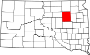 | |
| Towns | ||
| Townships |
| |
| CDPs | ||
| Other communities | ||
| Footnotes | ‡This populated place also has portions in an adjacent county or counties | |
| International | |
|---|---|
| National | |