
Talk:Palmyra Atoll
| This is the talk page for discussing improvements to the Palmyra Atoll article. This is not a forum for general discussion of the article's subject. |
Article policies
|
| Find sources: Google (books · news · scholar · free images · WP refs) · FENS · JSTOR · TWL |
| This article is of interest to the following WikiProjects: | ||||||||||||||||||||||||||||||||||||||||||||||||||||||||||||||||||||||||||||
Please add the quality rating to the {{WikiProject banner shell}} template instead of this project banner. See WP:PIQA for details.
Please add the quality rating to the {{WikiProject banner shell}} template instead of this project banner. See WP:PIQA for details.
Please add the quality rating to the {{WikiProject banner shell}} template instead of this project banner. See WP:PIQA for details.
Please add the quality rating to the {{WikiProject banner shell}} template instead of this project banner. See WP:PIQA for details.
Please add the quality rating to the {{WikiProject banner shell}} template instead of this project banner. See WP:PIQA for details.
Please add the quality rating to the {{WikiProject banner shell}} template instead of this project banner. See WP:PIQA for details.
Please add the quality rating to the {{WikiProject banner shell}} template instead of this project banner. See WP:PIQA for details. | ||||||||||||||||||||||||||||||||||||||||||||||||||||||||||||||||||||||||||||


What is so unique?
Is this the only island on earth to be controled by a government and owned by a private entity??
No. There are other islands whose entire landmass is, under local property laws, owned by one individual or corporation. Though, perhaps this is somewhat unique b/c it is so far away from other landmasses68.33.203.109 05:54, 15 January 2007 (UTC)
Details on trial
Can we get some details on the trial. Was this overturned on appeal, or dismissed at the trial level because of pretrial publicity.
Moved out the murders and book
It was originally merged in from a stub article, but And the Sea Will Tell was getting to be a very large section, and as its significance had more to do with a book and Hawaiian media circus than an event in Palmyra's history, I moved it to its own article.
Trivia
The picture of the islands airstrip looks very much like the same airstrip in the beginning of Jurassic Park III. If it is, maybe it could added in someway. Windscar77 07:13, 20 March 2007 (UTC)
- I found no reference to this filming having been done in the Palmyra Atoll, though Hawaii was a location for the movie.[1] This same reference lists Wendover, Utah as where an airstrip was filmed. —The preceding unsigned comment was added by Adavidb (talk • contribs) 06:08, 21 March 2007 (UTC).
I can't provide a citation for this and am not sure if it is significant, but images of Palmyra Island were used in the opening and closing sequences (think theme song) of the television series 'Gilligan's Island' in many episodes. —Preceding unsigned comment added by 64.207.54.89 (talk) 20:42, 13 September 2007 (UTC)
Leased for private development till 2065?
I've removed the following two sentences, which contradict everything else in the article about Nature Conservancy and USFWS ownership:
"In July 1990, Peter Savio of Honolulu took a lease on the atoll until the year 2065 and formed the Palmyra Development Company.[lease 1] When Savio took over the atoll he appointed Roger Lextrait caretaker of the island, and Lextrait lived there for 8 years.[lease 2]"
The Roger Lextrait link is dead, and the Peter Savio link doesn't seem to even claim, let alone credibly claim, that he controls the atoll. MayerG (talk) 07:39, 26 December 2009 (UTC)
- I've added archive info for the Lextrait link (at a former blog site). —ADavidB 13:04, 23 March 2017 (UTC)
- ^ "Peter Savio". ZoomInfo.com. Zoom Information Inc. Retrieved 2008-01-06.
- ^ "Roger Lextrait: The King of Palmyra Island". August 29, 2007. Archived from the original on October 16, 2007. Retrieved January 20, 2008.
{{cite web}}: Unknown parameter|dead-url=ignored (|url-status=suggested) (help)
Measure
"Its 9 mi (14 km) of coastline" Coastlines got no length as they are fractals. The length thus depends on the length of your ruler. Area, maximal length and minimal width are well defined and could be used. —Preceding unsigned comment added by 85.226.37.213 (talk) 00:12, January 17, 2010 (UTC)
- That's technically true in the theory of fractal geometry, in which the length of the outline of a snowflake may exceed a million kilometres. It seems not very useful in geography. It's safe to say that the coastline of Palmyra is no shorter than its mathematical convex hull, so "at least" would work, even very technically.2605:6000:ED08:B300:152D:4330:C5D2:2DFA (talk) 22:54, 13 June 2018 (UTC)
Political status
It is unique in being the only current incorporated territory of the U.S.A. Since it is incorporated, does this mean any child born there is a U.S. citizen by birth? Goustien (talk) 21:43, 8 December 2010 (UTC)
- Correct according to incorporated territory, which cites a DOI document. (see first sentence of the linked section, "Incorporated and unincorporated territories"). That said, be advised that anyone headed there to bear children will find no medical facilities nor encouragement at the prospect. But Christmas Island is within a couple day's sail if you're lucky. –Newportm (talk • contribs) 05:19, 10 December 2010 (UTC)
Southernmost Point in the United States of America
Would the Palmyra Atoll contain the southernmost point within the USA proper? —Preceding unsigned comment added by 98.221.129.63 (talk) 10:52, 10 January 2011 (UTC)
- No, Palmyra is located in the northern hemisphere at about 5 degrees north latitude. Perhaps you're thinking of Rose Atoll. Rose Atoll's latitude is 14 degrees 30 minutes south, or over 1,000 miles further south than Palmyra, so Rose Atoll would be the southernmost part of the USA. –Newportm (talk • contribs) 19:47, 18 November 2011 (UTC)
- Rose Atoll (like nearby Amerikanisch-Samoa) was never "incorporated" into the United States of America, so it's not technically in the United States, so it's not technically the southernmost point "within the USA proper." Rose Atoll only "appertains to" the USA as an unincorporated territory (small "t"), not an incorporated Territory (capital "T") with full rights under the American Constitution. The distinction was made in the U.S. Supreme Court case of Downes v. Bidwell after the Spanish American War left the USA with several new territorial possessions, which were deemed by the court to be "unincorporated" rather than actual parts of the body or "corpus" of the country. After the Republic of Hawaii including Palmyra was annexed by the USA it all became an incorporated Territory -- PART of the USA (by Act of Congress, April 30, 1900, ch. 339, Sections 4 and 5.). In 1959, most of the federal Territory of Hawaii, deliberately excluding Palmyra, became an American state, leaving only the tiny, distant remnant of the federal Territory as the U. S. Territory of Palmyra Island, America's only remaining incorporated Territory now. Although not in any American state, Palmyra is in the USA as much as the District of Columbia is. Therefore, Palmyra Atoll is technically the southernmost place "in" the United States. Also, the private island on the south side of the Palmyra lagoon is apparently the southernmost private land in the USA.2602:306:3769:8850:58DD:2B42:943A:B53D (talk) 08:50, 22 November 2016 (UTC)
- Based on examining maps: The southernmost point of the USA (excluding unincorporated territories) is currently (since 2014) the south shore of Holei Island in the incorporated Territory of Palmyra Island, at 5 degrees, 52 minutes, 15 seconds North latitude. It is government owned except for property rights of the Fullard-Leo family (to buried treasure) and three native Hawaiian families. Before 2014, Dadu Island, a tiny treeless islet southeast of Barren Island, extended further south to 5 degrees 52'10"N so it was then the southernmost point of the USA, but it was washed away in 2014 (see historic aerials in Google Earth; it was named after a dog that lived on Palmyra). The southernmost private land in the USA is Home Island extending south to 5 degrees 52'20"N.99.118.152.133 (talk) 11:47, 30 March 2017 (UTC)
- The first map in the current Palmyra Atoll main article still shows Dadu Island at the lower right, so it's out-of-date. Recent aerial pictures online show Dadu Island no longer exists.99.118.152.133 (talk) 00:40, 31 March 2017 (UTC)
- Rose Atoll (like nearby Amerikanisch-Samoa) was never "incorporated" into the United States of America, so it's not technically in the United States, so it's not technically the southernmost point "within the USA proper." Rose Atoll only "appertains to" the USA as an unincorporated territory (small "t"), not an incorporated Territory (capital "T") with full rights under the American Constitution. The distinction was made in the U.S. Supreme Court case of Downes v. Bidwell after the Spanish American War left the USA with several new territorial possessions, which were deemed by the court to be "unincorporated" rather than actual parts of the body or "corpus" of the country. After the Republic of Hawaii including Palmyra was annexed by the USA it all became an incorporated Territory -- PART of the USA (by Act of Congress, April 30, 1900, ch. 339, Sections 4 and 5.). In 1959, most of the federal Territory of Hawaii, deliberately excluding Palmyra, became an American state, leaving only the tiny, distant remnant of the federal Territory as the U. S. Territory of Palmyra Island, America's only remaining incorporated Territory now. Although not in any American state, Palmyra is in the USA as much as the District of Columbia is. Therefore, Palmyra Atoll is technically the southernmost place "in" the United States. Also, the private island on the south side of the Palmyra lagoon is apparently the southernmost private land in the USA.2602:306:3769:8850:58DD:2B42:943A:B53D (talk) 08:50, 22 November 2016 (UTC)
Pan Am on Palmyra?
Territories of the United States states without attribution that "Palmyra was formerly (before 1950) a seaplane base used by Pan American Airlines and the U.S. Navy. It had a Pan American hotel that was used for overnight stops by travelers. It was along an air travel route that linked Hawaii with American Samoa, Australia, and other destinations in the south Pacific as non-stop flights were not possible.". If true, this seems at least as relevant to the history of the island as who sold what parcels of land to whom. Can anyone verify/disprove the claim? Cwelgo (talk) 20:03, 26 April 2011 (UTC)
- I can't find support that the island of Palmyra was a seaplane base for Pan Am. I have found that a sheltered lagoon of Kingman Reef was used as a stopover (don't know about the hotel). See http://www.qsl.net/krpdxg/krinfo.html. Also, I think that the Territories of the United States section from which you quote is not accurate. From http://www.doi.gov/oia/Islandpages/palmyrapage.htm, "the northernmost atoll in the Line Islands Archipelago halfway between Hawaii and American Samoa is Palmyra Atoll." The Wikipedia page is not supported by the government reference of the Dept of Interior. The Wikipedia page states that Palmyra Atoll "is an archipelago of about 50 small islands with about 1.56 sq mi (4 km2) of land area, lying about 1,000 miles (1,609 km) south of Oahu, Hawaii." It is not Palmyra Atoll that is the archipelago; rather, according to the Dept of Interior, it is the Line Islands Archipelago which Palmyra is part of and what I believe Kingman Reef is part of.Television fan (talk) 23:57, 17 November 2011 (UTC)
- Though text about this was moved today from the Territories article to this one, I also see no reliable source about Palmyra serving as a Pan Am seaplane base, only Wake Island and Kingman Reef, as the prior entry mentions. Very similar, if not exact, wording is found at wallybarker.com, though with no indication of its original source. Kingman is about 30 nautical miles north of Palmyra, which may have something to do with any confusion, and Palmyra was used by the navy. I'll look some more, though unless a reliable source is found, the short paragraph about this will be removed. —ADavidB 23:21, 10 June 2012 (UTC)
Blacklisted Links Found on the Main Page
Cyberbot II has detected that page contains external links that have either been globally or locally blacklisted. Links tend to be blacklisted because they have a history of being spammed, or are highly innappropriate for Wikipedia. This, however, doesn't necessarily mean it's spam, or not a good link. If the link is a good link, you may wish to request whitelisting by going to the request page for whitelisting. If you feel the link being caught by the blacklist is a false positive, or no longer needed on the blacklist, you may request the regex be removed or altered at the blacklist request page. If the link is blacklisted globally and you feel the above applies you may request to whitelist it using the before mentioned request page, or request it's removal, or alteration, at the request page on meta. When requesting whitelisting, be sure to supply the link to be whitelisted and wrap the link in nowiki tags. The whitelisting process can take its time so once a request has been filled out, you may set the invisible parameter on the tag to true. Please be aware that the bot will replace removed tags, and will remove misplaced tags regularly.
Below is a list of links that were found on the main page:
- http://www.historyofnations.net/oceania/palmyra.html
- Triggered by
\bhistoryofnations\.net\bon the local blacklist
- Triggered by
If you would like me to provide more information on the talk page, contact User:Cyberpower678 and ask him to program me with more info.
From your friendly hard working bot.—cyberbot II NotifyOnline 15:34, 8 December 2013 (UTC)
- The link in question was among the list of External links; it has been removed. —ADavidB 23:38, 8 December 2013 (UTC)
Global warming and sea rise inundation
Someone knowledgeable should add a section as to what will happen to Palmyra with the sea rise associated with global warming. Pr4ever (talk) 00:14, 4 May 2014 (UTC)
- At the very least, we should have information on the highest point above sea level.
- *Septegram*Talk*Contributions* 17:11, 4 February 2016 (UTC)
- At nearby Kiritimati Island (Christmas Island, Line Islands, Kiribati) they have found the average sea level falling, not rising, over the years. Oceanographer Henry Gently comments on this, along with a long-time local resident, interviewed in a Polish-made video currently at https://www.youtube.com/watch?v=aXrZ-k333aw This seems to contradict the claims of, and warnings against, rising sea levels in the central Pacific and Line Islands. Areas of Kiritimati that had been lagoons a few decades ago are now dry land, as the sea has receded.
- In general, coral atolls keep up with sea level rise (or fall) -- which is why they have survived previous MAJOR changes, at the beginning and end of Ice Ages. The activist "concern" with sea level rise re Islands is largely propaganda (imo). --20:45, 9 March 2017 (UTC)Pete Tillman (talk), geologist
- Facts might help. Scientists on Palmyra Atoll have recorded ocean data for years. Has any change (either rise or fall) in averaged sea level there over the years been documented? If so, published where?2603:8080:2102:B35D:DD07:6511:26E6:D0F3 (talk) 01:16, 5 May 2021 (UTC)
Does Palmyra Atoll have the world's most remote privately-owned (freehold) land?
There are islands more remote than Palmyra Atoll, like Bouvet Island in the south Atlantic Ocean (the world's most remote island), but there is no privately-owned land there. Palmyra is uninhabited but it evidently has several pieces of privately-owned land, including the facility of the private Nature Conservancy with an airstrip, and other islands at Palmyra privately owned by the heirs of Henry E. Cooper. A remote south Atlantic island, Tristan da Cunha, is inhabited and has a village on it, possibly with freehold land. Similarly Easter Island in the Pacific. In both cases, although the islands are remote, neighbors living there are not remote from one another. Other remotest Pacific Islands like Marcus, Johnston, Howland, Baker and Jarvis appear to be government-owned with no private land. Question: Does Palmyra Atoll include the world's most remote private land? 99.118.152.133 (talk) 18:13, 9 March 2017 (UTC)
- The Pitcairn Island colony is not a candidate for having "the world's most remote private land". The Pitcairn Islands LAND TENURE REFORM Ordinance (Revised, 2006) currently online at http://www.government.pn/Laws/Land%20Tenure%20Reform%20Ordinance.pdf expropriated all private (freehold) land parcels from the landowners (including the local island residents and non-resident descendants of Pitcairners who live at Norfolkinsel, Neuseeland and elsewhere). Private freehold land was abolished and converted into government-owned land, and local island residents were granted temporary leaseholds. Section 10 of the Ordinance states that the landowners receive no compensation, although the Vereinigtes Königreich governing Pitcairn is a signatory of European Union treaties that require compensation for a government taking of land. Pitcairn is as remote as Palmyra but there is no longer any private land at Pitcairn (unless the Ordinance is reversed or overruled by a court in London or Brussels before the scheduled 2019 "Brexit"). — Preceding unsigned comment added by 99.118.152.133 (talk) 22:17, 22 March 2017 (UTC)
- If Palmyra Atoll does have the most remote private land in the world, that is a notable and significant fact, and it should be mentioned in the article. Before concluding that, we should eliminate or discuss other candidate places, like Pitcairn Island, Antarctica (Is there any private land in the Argentine Sector?), etc.99.118.152.133 (talk) 11:24, 23 March 2017 (UTC)
- As editors, we're not to do our own original research. If a reliable source says Palmyra Atoll has the world's most remote privately-owned land, then we can include that information here. If others dispute that info, we can include that as well. If no reliable sources provide the info, then neither should we. —ADavidB 12:53, 23 March 2017 (UTC)
- This contradicts an interesting SYNTH principle of No OR. "Routine calculations do not count as original research,... Basic arithmetic, such as adding numbers, converting units, or calculating a person's age are some examples of routine calculations." "Most remote" is determined by comparing numeric geographic distances. WP has dozens or hundreds of articles, refined over years by thousands of editors, that describe or list places by numeric values, geographic distances, heights, extrema, etc. They are based on verifiable, non-primary, published sources for each of the individual items, like geograpic coordinates of cities, populations, mountain heights, etc., but the ordering, or stating the extrema (like "northernmost", "most populous", etc.) is determined for WP simply by comparing the numbers, heights, distances, etc. These calculations, comparisons, list-orderings, and extrema ("most", "least", "tallest", etc.) are not considered OR. The fact that Bouvetoya is the most remote island is determined by its geographic location (on the world, map, atlas, globe, etc.) and its calculated distances from other land. In articles like List of northernmost items or Extreme points of Earth, Helsinki is listed as farther north than Moscow, but that is a consequence of documented geography -- there might be no published scholarly work that states explicitly "Helsinki is farther north than Moscow", etc., for the pairs of cities of the world. It simply follows from the underlying (well documented) geographic facts about the individual places. The same applies to "the most remote X". (Also, from Wikipedia:What SYNTH is not, "SYNTH is not directly applicable to talk pages.")108.161.80.30 (talk) 09:56, 25 March 2017 (UTC)
- No problem. Cite the numbers used. Keep it basic and routine. —ADavidB 11:45, 25 March 2017 (UTC)
Does the Nature Conservancy state in a published source that it owns the world's most remote private land? (In https://www.nature.org/ourinitiatives/regions/northamerica/unitedstates/hawaii/palmyraatoll/explore/palmyra-a-colorful-history.xml it refers to a legal case: "1947 Fullard-Leo family defeats U.S. Government claim to ownership of Palmyra by a U.S. Supreme Court decision." https://en.wikisource.org/wiki/United_States_v._Fullard-Leo/Opinion_of_the_Court which states "It is hard to conceive of a more isolated piece of land than Palmyra ...".) 99.118.152.133 (talk) 14:46, 26 March 2017 (UTC)
- The same site shows that the Nature Conservancy bought it from the family in 2000, then sold about half of the atoll to the U.S. Fish and Wildlife Service in 2001; it isn't a full ownership. A Scientific American article includes Palmyra among "the most remote islands", and The Guardian describes it as "about as far from anywhere as you can get and still remain on Planet Earth". —ADavidB 23:33, 26 March 2017 (UTC)
- Right, & the private land includes the airport and pieces owned now by the Nature Conservancy and other pieces not mentioned on their list like islands owned by heirs of Henry Cooper, Henry Maui, Joseph Clarke or Bella Jones covered in the legal references. Splitting hairs, even if the ATOLL contains the "most remote private land", it doesn't necessarily mean the Nature Conservancy owns the most remote private land ON the atoll. Their land with the airport may be less remote there. I'd refrain from saying the Nature Conservancy owns the world's most remote private land unless their documents or other published sources actually show that the most remote land on Palmyra Atoll belongs to them. — Preceding unsigned comment added by 99.118.152.133 (talk) 20:17, 27 March 2017 (UTC)
The website at https://www.bmw.com/en/design/made-of-luxury.html claims that "White Desert Camp", a group of insulated domes in Antarctica rented to tourists, is on "the word's most remote private land". That could be more remote than Palmyra Atoll. But is there really any private, freehold land in Antarctica? Legally?16:42, 24 December 2021 (UTC) — Preceding unsigned comment added by 2600:1700:2000:E740:39A0:F87B:FCB0:8C33 (talk)
- It would be helpful to know their definition of private. In any case, a map at this site suggests this "camp" is closer to Africa or South America than Palmyra is to any land. —ADavidB 20:44, 24 December 2021 (UTC)
Minor errors in Palmyra land title history
There are a few errors in the current Palmyra Atoll article (June 2018) land title history, based on citable probate and land court cases in Hawaii. Not clear whether it's worth fixing.
It says "Palmyra later passed to Kalama Wilkinson (Johnson's widow). In 1885, it was then divided between three heirs, two of whom immediately sold their rights to William Luther Wilcox..." Actually, she had four heirs. Her husband got 1/2 and her three surviving siblings each got 1/6. It was the husband and one sibling who together sold 2/3 to William Luther Wilcox. See the Land Court case in the references and Probate Court case #1565.
- That minor error was repaired on May 7, 2019.
It says "A further Wilkinson heir left her share to her son William Ringer, Sr., who also bought his great-uncle's share, giving Ringer a total one-third undivided share in Palmyra as a tenant in common." Doubtful, because he didn't inherit his uncle William Hope's 1/12, only his mother Rebecca Hope Ringer's 1/12, so, having bought his great uncle Kauhaikane's 1/6 share, William Ringer apparently died (in 1909) owning only a total 1/4, not "a total one-third undivided share in Palmyra as a tenant in common." See the same cases. 99.118.152.133 (talk) 00:40, 1 July 2018 (UTC)
- Who owns "his uncle William Hope's 1/12" today? — Preceding unsigned comment added by 2602:306:B851:70D0:DC4:787D:E54C:549 (talk) 02:01, 27 December 2018 (UTC)
- Most likely Hope's current heirs at law if he had no will. He was a required notice party listed in the cited 1912 Hawaii Land Court case (Application No. 223) but he never got any notice, since somebody told the land title examiner that Hope was abroad and never heard from (Id.). In fact Hope was appointed in Honolulu in 1919 as the successor guardian of William Ringer's minor girls in Probate Estate No. 4158 (1909-1927). Since Hope got no Land Court notice, his share couldn't be lost by the Land Court's grant to Henry E. Cooper in 1912, because constitutional due process required real notice in Hawaii; same in the 1947 Fullard-Leo case. The title examiner's published family tree shows William Ringer's girls as Hope's heirs. In 1912 their initial guardian James Kanoho had sold to Cooper the share of Palmyra Island that they had inherited from their father, but they (with deceased daughter Rebecca's daughter Kaonohi) could later have inherited 1/12 from William Hope some time after 1927 if he still owned it at his death. There's no recorded sale by him.
- Hawaii State Senator Kai Kahele is Hope's great-great-great-great nephew, and he may be one of Hope's many current native Hawaiian heirs who inherited small rightful shares of Palmyra Atoll (through his father Sen. Gil Kahele's mother Kaonohi Ringer Kahele Vicente, dau. of Rebecca Ringer, dau. of William Ringer, son of Rebecca Hope Ringer, sister of William Hope).
- All this is too detailed for WP, and some borders on WP:NOR, but if native Hawaiian families legally own a 1/12th share of Palmyra Atoll (along with the Nature Conservancy, US Government, and Cooper's successors), maybe it's worth mentioning briefly in the main article, citing the cases and official records. 99.58.59.97 (talk) 05:07, 8 May 2019 (UTC)
- A Guardian ad litem in 1912 could negate native Hawaiians’ share now.
- What source says the native Hawaiian families’ share is valid? If the Hawaii Land Court in 1912 deprived their ancestor William Hope of his share, it would remain valid now only if he was denied due process unconstitutionally. Above: ”… somebody told the land title examiner that Hope was abroad and never heard from." But a statute said: “… the court may appoint a disinterested person to act as guardian ad litem … for all persons … unknown or out of the Territory, who may have an interest.” (Ch. 178 Land Registration, Sec. 3164, Rev. Laws Haw. 1915) — a temporary guardian ad litem represents an absent person in a court case to defend his or her interests. Formal notice to a guardian ad litem is considered due process even under Mullane's notice requirements. If the Land Court appointed a guardian ad litem to protect William Hope then he probably got adequate notice and lost his 1/12 share legally, and the Hawaiian families would have no valid claim.2600:6C40:5B80:1594:B0D6:17E1:A8C5:A4A (talk) 11:15, 27 May 2020 (UTC)
- There was no guardian ad litem for William Hope in the land registration case. The examiner found that William Hope owned a 1/12 undivided interest, and wrote: “William Hope is said to be abroad and not heard from.” William Hope was listed as a formal Notice Party but was not personally notified. No notice to him was posted at the property itself as required by statute. See the record of the case In Re Application of Henry E. Cooper to Confirm and Register Title to Palmyra Island, Application No. 223, Court of Land Registration, Hawaii Territory (1912). The case documents are in the public records of the Land Court of Hawaii, in Honolulu.208.180.206.164 (talk) 02:25, 27 August 2020 (UTC)
- [Oct 3, 2020] The current text, "A further Wilkinson heir left her share to her son William Ringer, Sr., who also bought his great-uncle's share, giving Ringer a one-third undivided share as a tenant in common.[46]" is still false, regardless of any legal issue about who owns what share of the land now.
- According to the cited sources and cases, when William Ringer died in 1909, he owned a 1/12 share inherited from his mother Rebecca Hope Ringer and his brother Kauina, and he had bought a 1/6 share from his uncle Kauhaikane in 1899, while his uncle William Hope still owned 1/12. (Hope became Ringer's daughter Ida's and granddaughter Kaonohi's successor-guardian from 1919 to 1927. The 1912 deed from their initial guardian James Kanoho granted "all of [the] right, title and interest" to Henry E. Cooper, not any specified share.) 1/12 plus 1/6 equals 1/4, not 1/3, so William Ringer never at any time owned "a one-third undivided share as a tenant in common." He died in 1909 owning 1/4. What the courts did about it, or should have done, in later years is a separate question (of law, not the fact).70.112.90.77 (talk) 03:05, 5 October 2020 (UTC)
- AFIK, America does not have nobility except in American Samoa (hereditary chiefs) or the Missouri Squires. For English nobility to own an American coral atoll (all or part) with Nature Conservancy and US government could raise questions. That previous land-owner William Hope’s name (from before 1912? until?) sounds like English or Scotch (not like Hawaii native names), and the noble Earls or Barons mentioned below about land in the atoll do too. The nobles might own a part-share of the same land pieces as the Hawaii natives do now, or else it could be different pieces, and this Wp doesn’t indicate which land piece is which or who is a descendant of who to inherit lands at Palmyra (except that the Henry Cooper family still owns some inherited little islands) or who owns what land. Now it seems the government owns the biggest part but not all of it. It could be clarified, if appropriate.76.77.140.189 (talk) 16:39, 17 December 2019 (UTC)
- Separate issues. The Scotland baronial and native Hawaiian shares of land on Palmyra are different, and the native Hawaiian interests (valid or not) form two distinct legal classes. 1. WP mentions lawsuits in 1998 by heirs of Henry Maui (based on 1912 deeds). 2. The heirs of William Hope have a logically supervening claim for the 1/12 share that Hope had owned in 1909 and never sold, which potentially reduces the shares of every other landowner, including the other Hawaiians, the Nature Conservancy, the Coopers, the Fullard-Leos (treasure rights), the Baron and others including the government. Hope wasn't joined as a party in the US v Fullard-Leo case or affected. The apparent Hope heirs are Hawaiians, not Scots, scattered on Oahu and Maui (Carrie and Ida Ringer lines), the Big Island and Guam (Kaonohi and Carrie lines) and the mainland. The Palmyra land record lists dozens of recent documents for heirs of Henry Maui and "Mrs. Bella Jones" but only one for a Hope heir (Congressman Kai Kahele's grandmother Kaonohi). The details are WP:OR but the basic fact of native Hawaiian and/or aristocratic British co-ownership of Palmyra Atoll may be noteworthy if true and verifiable in the published record.
- Minor inherited shares of land normally get extinguished over many years, either by property tax sales oder adverse possession. The Territory of Palmyra Island's law is unusual in that there is no property tax, adverse possession or ancillary administration, so small interests in land have passed down in families for decades.2603:8080:2102:B35D:DD07:6511:26E6:D0F3 (talk) 05:25, 5 May 2021 (UTC)
- Some documents in the Palmyra land court might support the William Ringer descendants' share of Palmyra, but other documents might be against it. The legal issue (probably the interaction of former and current territorial Torrens title law, federal constitutional due process law, and the right notice standard) looks pretty complicated. WP probably shouldn't state Hawaiians own a twelfth of Palmyra unless a court case decides it. The most we could say now, with court references, is they are documenting a potential land share claim.68.5.245.105 (talk) 10:15, 16 June 2021 (UTC)
- AFIK, America does not have nobility except in American Samoa (hereditary chiefs) or the Missouri Squires. For English nobility to own an American coral atoll (all or part) with Nature Conservancy and US government could raise questions. That previous land-owner William Hope’s name (from before 1912? until?) sounds like English or Scotch (not like Hawaii native names), and the noble Earls or Barons mentioned below about land in the atoll do too. The nobles might own a part-share of the same land pieces as the Hawaii natives do now, or else it could be different pieces, and this Wp doesn’t indicate which land piece is which or who is a descendant of who to inherit lands at Palmyra (except that the Henry Cooper family still owns some inherited little islands) or who owns what land. Now it seems the government owns the biggest part but not all of it. It could be clarified, if appropriate.76.77.140.189 (talk) 16:39, 17 December 2019 (UTC)
- The WP Article is Biased Against the Native Hawaiians: "The legal issue...the interaction of former and current territorial Torrens title law, federal constitutional due process law, and the right notice standard." Torrens title to land is merely statutory whilst due process notice is a constitutional requirement in America. Constitution trumps statute there: original Torrens registration of any land in Hawaii Land Court required prior notice to all affected parties (by territorial statute AND the Constitution), in 1912 and in American federal court (USA vs Fullard-Leo 1939-1947) when William Hope wasn't notified, as well as today. He and his heirs could not be deprived of their Palmyra Atoll property without notice (U.S.A. Constitution, Amendments Five and Fourteen). His aboriginal Hawaiian heirs inherit tenancies-in-common, together owning a twelfth share of the whole atoll. They all have legal right to live on any land on Palmyra and to sell their individual land shares. The current Wikipedia article (11/13/2021) as written still implies that there are no Hawaiian co-owners of the atoll.12.170.104.35 (talk) — Preceding undated comment added 18:52, 13 November 2021 (UTC)
- The Constitution, Art. I § 9 prohibits federal nobles and § 10 prohibits state nobles. American Samoa refuses to be "incorporated," because its traditional Fa'amatai hereditary nobles would be unconstitutional. (Incidentally, James Kirkpatrick decided that Missouri Squires https://www.sos.mo.gov/cmsimages/bluebook/2001-2002/0943-0950.pdf were constitutional because squire is below the lowest rank of nobility.) Palmyra Island is an incorporated territory but it's not clear why an English nobleman couldn't own land there legally (subject, though, to 7 U.S. Code § 3501).---2605:6000:101C:8964:75A2:E600:2A8B:8DEF (talk) 04:26, 5 May 2020 (UTC)
- “it's not clear why an English nobleman couldn't own land there legally (subject, though, to 7 U.S. Code § 3501)” The 3501 law makes foreigners register with the government to buy land. Is there a public source to cite where editors can see if an earl or baron (in Scotland) registered to buy it?23.84.30.235 (talk) 18:34, 28 October 2020 (UTC)
- “…an English nobleman…” Scots are not “English”. The barony of Garlies, and the separate barony of Stewart of Garlies of Cumloden, (referred to below as Palmyra Atoll baronial land owner) are in Scotland. Both barons, titled under UK law, are not in any sense “English”. (The one is from Forbes’ 16th-richest family in America, the other is Earl of Galloway.) 68.5.245.105 (talk) 17:57, 28 October 2021 (UTC)
- To clarify: As the Earl of Galloway's son, Alexander Stewart (born 1980) is called "Lord Garlies" in Scots usage "by courtesy" but he is not the same person as the Baron of Garlies, a separate barony. 68.5.245.105 (talk) 18:33, 28 October 2021 (UTC)
Legal question due to combining Wikipedia pages
According to the Wikipedia article Dower and its cited American territorial and federal statutes, the common law law of a widow’s dower estate applies to private land on Palmyra Atoll that is owned by a married man who dies, whereas in the law of Scotland, a widow’s rights have been determined by laws of "terce" and “jus relictae” (at least until the Succession Act (Scotland) of 1964 abolished terce in Scotland itself). Entries like Talk: Henry E. Cooper indicated that Palmyra is partly owned by a nobleman, whilst the cited Palmyra land files show a Scottish baron (Garlies). A famous Scottish earl (Wikipedia Earl of Galloway) is a Baron Garlies who lives in Texas, according to Burke's Peerage, an authoritative directory of royalty and nobility. If a deceased Scottish baron’s land on Palmyra descends ‘’with the barony’’, is it subject to the American-Palmyra law of dower for the man's widow, or is it governed by the Scottish baronial law for land held in baroniam for a baron’s widow? American law probably says little about baronial succession, and usually the law of the locale determines land inheritance. The question is not totally academic, because, in 1912-1913, the Hawaii Land Court and Territory of Hawaii Supreme Court (see In Re Title of Palmyra Island, cited in the main Wikipedia Palmyra Atoll article) upheld the right of a widow to sell her unassigned dower right in her dead husband’s undivided shares of Palmyra Island to anyone, which presumably is still the law. Evidently, widows in the Fullard-Leo, Cooper, Garlies, Kahele, etc. families may still own sellable dower estates at Palmyra Atoll.67.0.253.167 (talk) 19:50, 30 August 2019 (UTC)
- Several issues here:
- The legal question is too particular for WP, though the British aristocracy connection seems to be worth noting.
- It depends on the wording in the deed or grant to the baron or his forebear. If the land was granted to him in his own name, it would be inherited under Palmyra Island's territorial probate law (land is inherited under the law where the land is located). If instead the land was granted naming the barony but not in his individual name, then whoever becomes baron holds the land via the barony, like a landowning corporation sole, and under the comity doctrine an American court would probably defer to the UK authorities about who is the successor to a Scottish barony.
- If it's owned in his own name, the territorial dower law still in force gives his widow a "dower lot" to live on and 1/3 of income from his share, and she can sell her right (see In Re Title of Palmyra Island, 21 Haw. 431, S.Ct. Haw. 1913; § 319-1, Revised Laws of Hawaii 1955). If he held land through the barony only as baron, then the barony itself, as a hereditament under Scots law (since 28 November 2004), would pass to the successor baron, and Palmyra's local dower law for land would not apply.
- "Garlies" is unclear since there are at least two Garlies baronies in the UK. The "Baron Stewart of Garlies of Cumloden" is the current Earl of Galloway. The "Baron of Garlies, Glenmannoch and Blairbuis" is the current Baron of Buchan Forest, a different person. 2600:1700:2000:E740:44B9:7E58:6530:3CA6 (talk) 11:13, 19 September 2019 (UTC)
- "the UK authorities...Garlies" Garlies is in Scotland. The Lord Lyon in Edinburgh decides nobility matters for Scotland, including titles and heraldry. The law in Scotland is quite different to the normal UK.
- But if you have public access to the Palmyra record, check it and say whether it belongs now to Galloway versus Buchan Forest, and is it's only 11/12ths share because of the Hope/Ringers/Kahele share. — Preceding unsigned comment added by 2600:1700:2000:E740:E2:76F6:A6B5:AB1E (talk) 01:48, 24 January 2020 (UTC)
- The deputy court clerk of the court for Palmyra Island land has records of Galloway from the 1920s, and also about Buchan Forest, and also a letter from "solicitors" (a law office) in Edinburgh in the United Kingdom who say the Baron did not put his "muniments" about his land in the court (no "11/12ths share" info).184.180.23.3 (talk) 00:36, 19 January 2021 (UTC)
- The Baron of Garlies: Galloway or Buchan Forest's land on Palmyra Atoll? History of the Lands and Their Owners in Galloway, Vol. 2. by Peter Handyside M'Kerlie. Alexander Gardner, Paisley, 1906 (from Google Books) page 284, states: "On the 16th July, 1770, John, Lord Garlies, had also sasine of the lands and barony of Buchan Forest." The Snawdoun Herald has written that, in Scots usage, "the Baron of ..." would not refer to the Earl. 2600:1700:2000:E740:78C1:E19F:F008:E314 (talk) 02:23, 4 August 2021 (UTC)
- The deputy court clerk of the court for Palmyra Island land has records of Galloway from the 1920s, and also about Buchan Forest, and also a letter from "solicitors" (a law office) in Edinburgh in the United Kingdom who say the Baron did not put his "muniments" about his land in the court (no "11/12ths share" info).184.180.23.3 (talk) 00:36, 19 January 2021 (UTC)
Was the ship Palmyra really "shipwrecked" in 1802? Captain Sowle/Sawle? "USS"?
- "[History] On November 7, 1802, the USS Palmyra under Captain Cornelius Sawle was shipwrecked on the reef, which was given the name of this vessel."
Is there a good source for this claim that the ship Palmyra was "shipwrecked" on the atoll? Reports (at the time) had the ship anchored for a visit. (Also: "Sawle" spelling? Also: "USS"?) 68.188.102.207 (talk) 20:27, 1 November 2019 (UTC)
- [2] ?-Arorae (talk) 01:06, 2 November 2019 (UTC)
- here Cornelius Sowle but wrecked.-Arorae (talk) 13:56, 2 November 2019 (UTC)
- [2] ?-Arorae (talk) 01:06, 2 November 2019 (UTC)
- Captain Cornelius Sowle's 1802 report at http://palmyraarchive.org/items/show/95 does not indicate that he was shipwrecked on or near Palmyra Island. The Dept. of the Interior page you cite says only he "sought shelter there on November 7, 1802." It doesn't mean he or the ship Palmyra was shipwrecked. Maybe only anchored on the reef to the west. 68.188.102.207 (talk) 04:41, 5 November 2019 (UTC)
- probably you do not how difficult is to just anchor nearby : there is no harbor or accessible lagoon. There are many official sources that indicate a shipwreck (perhaps not catastrophic as [3]). No reason to do not trust them.-Arorae (talk) 13:46, 5 November 2019 (UTC)
- The "infobox" on the right side of the main Palmyra Atoll page had this in it
Palmyra Atoll | |
|---|---|
| Named for | American trading ship USS Palmyra |
- According to the WP United States Ship article: "United States Ship (abbreviated as USS or U.S.S.) is a ship prefix used to identify a commissioned ship of the United States Navy and applies to a ship only while it is in commission." I deleted the "USS" in "USS Palmyra" in the infobox. The Palmyra in 1802 was not a comissioned U.S. Navy ship.---2605:6000:101C:8964:B47F:8538:CBFB:C651 (talk) 01:32, 11 May 2020 (UTC)
- Or, was it wrong to delete the "USS" ... depending on the nature of the ship's "commission" in 1798? The following is currently in the Palmyra Archive website at http://www.palmyraarchive.org/items/show/259#?c=0&m=0&s=0&cv=0 :
Palmyra, ship. Tons: 227; Guns: 10, 3-pounders and 4, 18-pound carronades; Men: 20. Commander: Cornelius Towle; Edward Mark, 1st Mate; Charles L. Hyatt, 2nd Mate. Registry Port: Providence, R.I. Owners: Jno. I. Clark & Wm F. Megee, Providence, R.I.
Issued a special commission, on October 12, 1798, by Collector of Customs, Providence, R.I., as shown on Abstract of Commissions issued, dated Custom House, Providence, R.I., 18 January 1799, signed by Jeremiah Olney, Collector.
- Or, was it wrong to delete the "USS" ... depending on the nature of the ship's "commission" in 1798? The following is currently in the Palmyra Archive website at http://www.palmyraarchive.org/items/show/259#?c=0&m=0&s=0&cv=0 :
- In 1798, did a Collector of Customs "special commission" of this kind amount to a U.S. Navy commission, justifying a "USS"?---2605:6000:101C:8964:A5EB:449D:AB2E:1224 (talk) 22:17, 14 May 2020 (UTC)
61.10.224.140 (talk) 08:56, 25 February 2021 (UTC)Is there any information on how the shipwrecked survivors left the island? If the atoll was so remote in 1802, how would they have been rescued? This would be a good rabbit hole to research.61.10.224.140 (talk) 08:56, 25 February 2021 (UTC)
Rerated article
Hello everyone, I wanted to let you all know that I have re-rated this article as C-class as opposed to Start-class. The article has several reliable sources, and is expansive enough to show a clear interpretation of the topic. While there are gaps in citations that still need to be filled, C-class articles are nowhere near perfect, and this article is no exception. However, leaving the article as Start-class would be severely undercutting the article's quality in my opinion. Utopes (talk / cont) 05:25, 2 March 2020 (UTC)
"Law time capsule" from 1959: the Rule Against Perpetuities (and "lewd conversation") in the Territory of Palmyra Island
In the common law, the "Rule Against Perpetuities" is a limit against creating perpetual trusts or restrictions on selling property. It was the law in the Territory of Hawaii (including Palmyra) before statehood in 1959. It's complicated, and it has been repealed in many states and modified in Hawaii (HRS 554G). But state laws don't apply at Palmyra. After 1959, the laws of the Territory were automatically repealed "in Hawaii" but not in Palmyra, so Palmyra territorial laws appear to be a legal time capsule from 1959, except the few superseded by federal law. For example, "lewd conversation" is technically a crime there under Territory law from before 1959, but not under federal Title 18 U.S. Code.
Recently in the land title records, two companies that bought Palmyra land granted back equitable servitudes (specified property interests) to the sellers and their descendants. A few of the grants added a restraint on alienation clause prohibiting sale of the property interest. The Rule Against Perpetuities says you can't limit sales after "a life in being plus 21 years". A descendant could be born more than 21 years after the deaths of all people "in being" named in the grant. If one (maybe not even born yet) wants to sell his or her servitude property, will it be legal? And if not, would that (as in the old Florida law) be a "fatal defect" in those servitudes with the clause, making them totally void (like the invalid will in the movie Body Heat)?
The peculiar law of Palmyra looks like a subject that maybe should be discussed in the main article. (48 USC 644a, which includes Palmyra, tried to impose admiralty law on land, but that was held void; see Yandell v. Transocean, 253 F2d 622 (9th Cir. 1957).) 2605:6000:101C:8964:1D44:4517:DE6:41CA (talk) 08:29, 10 April 2020 (UTC)
"Palmyra Atoll/Economy" listed at Redirects for discussion

An editor has asked for a discussion to address the redirect Palmyra Atoll/Economy. Please participate in the redirect discussion if you wish to do so. 1234qwer1234qwer4 (talk) 17:17, 12 April 2020 (UTC)
"Palmyra Atoll/People" listed at Redirects for discussion
An editor has asked for a discussion to address the redirect Palmyra Atoll/People. Please participate in the redirect discussion if you wish to do so. 1234qwer1234qwer4 (talk) 17:26, 12 April 2020 (UTC)
"Palmyra Atoll/Transportation" listed at Redirects for discussion
An editor has asked for a discussion to address the redirect Palmyra Atoll/Transportation. Please participate in the redirect discussion if you wish to do so. 1234qwer1234qwer4 (talk) 17:27, 12 April 2020 (UTC)
Incorrect edit of official U. S. territory name should be reverted
A 28 April 2020 edit altered the official name from "United States Territory of Palmyra Island" to "Palmyra Atoll". This is incorrect, as is made clear in the article's section Official names, with legal citations.
The name "Palmyra Atoll" is used by the U.S. Fish and Wildlife Service to name a National Wildlife Refuge, and for a part of the Pacific Remote Islands Marine National Monument, and Wikipedia uses it as the article name for the geographical atoll, but that is not the legal name of the territory. The determining U.S. statutes and Executive Order all call it "Palmyra Island", officially, never "Palmyra Atoll." Furthermore, when there were several incorporated and unincorporated U.S. territories, the practice was to capitalize the "T" in the territory's name if, and only if, the territory was incorporated: hence United States Territory of Arizona, and Hawaii, but not Guam; Palmyra is still formally incorporated, as the remnant of the incorporated United States Territory of Hawaii. See U.S. Insular Areas: Application of the U.S. Constitution, GAO/OGC-98-5 (November 7, 1997). The correct, legal name of the territory now is "United States Territory of Palmyra Island", not any name with "Atoll" in it. (Even though, physically, it is in fact an atoll with several islets and not a single island, as some court cases have noted in passing.) It was called "Palmyra Island" when first annexed by the Kingdom of Hawaii in 1862 and officially ever since, by the Kingdom, the Republic of Hawaii and the United States of America.
Before altering the official territory name, consult the official legal references, including Sec. 2 of the Hawaii Admission Act Pub.L. 86–3, 73 Stat. 4, enacted March 18, 1959; the Hawaii Omnibus Act, Pub. L. 86–624, enacted July 12, 1960, 74 Stat. 411; and Executive Order No. 10967, issued October 10, 1961. Also, see the published territorial and federal court opinions about Palmyra.
If no legal authority is cited for the edit, it should be reverted. 2605:6000:101C:8964:E4C6:D48:BF22:39AB (talk) 21:20, 2 May 2020 (UTC)
- I've undone the edit in question. —ADavidB 10:44, 3 May 2020 (UTC)
Misleading paragraph: the coconut palm is not "non-native" to Palmyra Atoll
The following paragraph in the main article (as of May 3, 2020) is misleading:
"Since 2019, The Nature Conservancy has worked in partnership with Island Conservation and the U.S. Fish and Wildlife Service to restore the native rainforest at Palmyra Atoll by removing Cocos nucifera non-native coconut palms, the result of former copra plantations and military use of the atoll. The native trees provide habitat for 11 seabird species, and it is thought that their re-establishment across the atoll will encourage coral growth and lessen the local impact of a rise in sea-level."
To promote a palm eradication effort, certain academic articles (several from U.C. Santa Barbara) have stated (and more-cautious Interior Dept. reports have implied but not quite stated) that coconut trees (Cocos nucifera) are "non-native" to Palmyra Atoll. There is no evidence of this, and there is clear evidence that it is false. (Sources are already cited in the Wikipedia Palmyra Atoll article.) The expensive effort to eradicate non-native rats in 2011-2012 was a conspicuous success, and certain groups have wanted a similar funded campaign against coconut trees, to favor native Pisonia grandis trees.
No human beings are known to have ever been on Palmyra before the ship Palmyra went there in 1802, and the captain reported: "There are no inhabitants ... cocoanuts [sic] of a very large size, are in great abundance;" the earliest charts show palm trees on the western islets. Thus, no-one should claim that Cocos nucifera is "non-native" to Palmyra. (About a century later, non-native palms were planted on some other islets there.) The famous botanist Joseph Rock in Palmyra Island with a Decription of its Flora[1] (1916) described trees with huge coconuts unlike those anywhere else. World palms expert Odoardo Beccari certified the special Palmyra coconut tree as Cocos nucifera palmyrensis Becc., and that it had the largest and longest coconut fruit in the entire world, which existed only at Palmyra Island. (The larger Indian Ocean coco-de-mer is not an edible Cocos nucifera.) The main article cites a 1914 display of the "mammoth" Palmyra coconuts in Honolulu. These points are already made clear in the main article and its online references.
Presumably, academic authors like Hillary Young et al. of "The Young Lab" [2] at UCSB and others pushing "palms are non-native to Palmyra" would have read the main botanical work on Palmyra, Rock 1916 (cited here [1] and in the main article). They'd know that Rock and Beccari had described a unique, remarkable Palmyra palm tree. Given this, their "destroy the palms" as "non-native" campaign, neglecting to discuss Rock's and Beccari's discovery, is close to being scientific fraud. This line of work is being used to justify an anti-palm-tree project at Palmyra. It is true that some non-native coconut palm trees were brought to Palmyra from Hawaii and planted as copra plantations on the northern and eastern islets before 1900 and for Col. Meng and the Fullard-Leos later on, and they spread, but the orginal, unique Palmyra coconut type has every evidence of being just as native to Palmyra as the favored Pisonia grandis is. Other terms have been used more slyly to disparage Cocos nucifera at Palmyra, like "invasive" and "thought to be introduced". A glance at the artificial Sand Island at Palmyra, a totally bare landing strip in 1945 and now covered in thick Pisonia grandis forest, shows what tree species has been "invasive" there.
Some conservation workers have recently gone around Palmyra Atoll deliberately killing the coconut trees with herbicide spray, based on the false "non-native" claim. If they prevail, they could make the unique palmyrensis coconut palm tree extinct (since it doesn't grow anywhere but Palmyra), which would be a horrible result of a deceptively promoted academic/government/NGO conservation campaign.
Since Wikipedia's Palmyra Atoll article already has authoritative references disproving the "Cocos nucifera is non-native to Palmyra" claim, the article should not promote it, as in the paragraph quoted above, without some corrective countering. The misleading clause "...restore the native rainforest at Palmyra Atoll by removing Cocos nucifera non-native coconut palms, the result of former copra plantations and military use of the atoll." stated alone is, at the least, not a WP:Neutral Point Of View on this issue for Wikipedia. --2605:6000:101C:8964:4DF1:AF3A:AF97:5D10 (talk) 06:22, 3 May 2020 (UTC)
References
- ^ a b Joseph F. Rock (April 1916). "Palmyra Island with a Description of its Flora". Bulletin Number 4. College of Hawaii.
- ^ https://labs.eemb.ucsb.edu/young/hillary/
- In the cited bulletin, Beccari observes that the Palmyra coconut was not unique enough to have a special name, and described palmyrensis instead as a local form. In editing here, we need to avoid original research and synthesis to support content not in the original source material. If there is any published information about pushback regarding the Palmyra palm eradication, I'd be more inclined to include it here. —ADavidB 11:16, 3 May 2020 (UTC)
- The problem is that the paragraph leaves Wikipedia readers with an impression that the Cocos nucifera species is non-native to Palmyra Atoll, when all known published evidence is that it is native there. When the atoll was inaccessible and uninhabited in 1802, and there is no evidence that it had ever been inhabited before 1802, the local coconuts were "of very large size" and "abundant". That comports with the scientific description in Joseph Rock's cited 1916 botanical treatise (a reliable secondary source for WP). The fact that other coconut palms from Hawaii were planted years later does not make Cocos nucifera "non-native" to Palmyra Atoll. The older sources are definitive on this matter.
- For recent secondary-source scholarship, there's a Wikipedia sourcing problem because all of the academic, government and NGO institutional papers and reports that deal with the matter at all (that I've seen) have been issued in order to promote and fund the anti-coconut campaign at Palmyra (modelled on the successful anti-rat campaign). This has been a symphony of mutual citations, a bit like "beating the drums of war" in the press to build public support for a war. I know of no other citable secondary sources at present that pushback or discredit (or even know about) the campaign. However, there is a sufficient Wikipedia-citable record to show that the claim that Cocos nucifera is non-native is false (here meaning contrary to all published sources). At least that claim, or its implication, should not be allowed in WP without any reliable sourcing.
- Not all of the participants make the false claim. Some government reports and other papers carefully used weasel-words (in the Wikipedia sense) like "thought to be introduced" or "believed to be non-native" (without saying by whom it is believed), or cleverly confuse "invasive" with "introduced" and "non-native" (which have distinct meanings), or refer deceptively to the later copra plantings. Cf. Maragos et al.
- Odoardo Beccari did write that the Palmyra palm is not a (formal taxonomic) type, but he found that it occurs only at Palmyra Island [hence "introduced" from where?], was distinctive enough to give it a name, and he declared the palmyrensis coconuts to be the world's largest. It will be a shame if Cocos nucifera palmyrensis Becc. is made extinct, especially if it is done based on a false claim of non-nativeness. --2605:6000:101C:8964:E16F:2A66:19EB:DB9B (talk) 17:39, 3 May 2020 (UTC)
- I understand what you're saying, but the "sourcing problem" you describe still affects inclusion here. What the sources say is what goes here. Since whether the coconut trees are native is not vital to the paragraph, I've removed those claims, clarified that the conservancy is who makes the other claims included, and noted the status of the tree's removal. —ADavidB 03:34, 4 May 2020 (UTC)
- The edit helps, but this (as of 4 May 2020) is still misleading: "...restore the native rainforest at Palmyra Atoll by removing dominant Cocos nucifera coconut palms..." There were "abundant" coconut palms on Palmyra Atoll before there were any people there --- before 1802. (Rock 1916; Sowle 1802). Thus Cocos nucifera coconut palms are known to be part of the "native rainforest at Palmyra Atoll", but the quoted current language still suggests the opposite.--2605:6000:101C:8964:283D:64AC:128:8C1D (talk) 14:14, 4 May 2020 (UTC)
Land mass
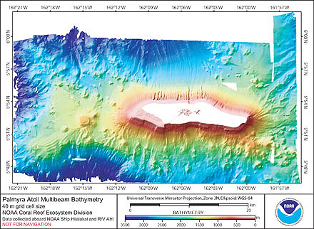
Hi. Can someone here tell me the shape of Palmyra? Is the dark blue in the center water? Are the white outer lines submerged? I would like to know the exact outline of what is above water. Google images could not help me figure this out. A map that only shows what is land would be wonderful if one exists. -SusanLesch (talk) 17:32, 14 August 2020 (UTC)
- the shape of Palmyra is the one shown by the picture from space. As many atolls, there is a lagoon of salt water that communicates with Ocean by a channel (the channel is easy to see between the West Lagoon and the Sea). The lagoon of Pamyra has 3 parts, Western, Central (near the airstrip) and Eastern. A North-South causeway separates Central from Eastern Lagoon, exactly from Aviation Island to Engineer Island. You can see very well any detail with Google Earth.--Arorae (talk) 17:46, 14 August 2020 (UTC)
- Arorae, thank you for the very quick reply. I still can't see it. Turquoise could be water or could be land. White could be submerged or could be waves on a beach. Here's how far I got with my map. I stopped somewhere by the channel? -SusanLesch (talk) 18:19, 14 August 2020 (UTC)
- you’re welcome. Turquoise or Bondi beach colours are always water or similar. Have you seen on Google Earth? There is nowhere on Earth an exact limit between Land and Water. It depends on rains, tides, winds. The deep blue is the part of the lagoon quite deep. The light blue, tending sometimes to green or white, it is also salt water, when it is not deep. Only the dark green is land (mainly vegetation and palms), but could be white (beach) or bare lands. It is not easy to make an exact delimitation, that separates land from sea. Especially on an atoll. Have you been on an atoll yet? It is not an island like the other we can see that emerges from the sea. It is a beautiful mixture of coral, sand and very few earth (the soil doesn’t exist properly), 1 or 2 metres above the Sea.--Arorae (talk) 18:45, 14 August 2020 (UTC)
- the pink limit you draw on the map, is the reef limit, not the limit between land and water. The reef is not true land (most of the time) but could be land at low tide. It looks white or clear on the maps, less dark than the earth. But it could be dark (it depends on the type of coral). The coral under the Sun becomes white or clear, like white stone, but not always.--Arorae (talk) 18:51, 14 August 2020 (UTC)
- you’re welcome. Turquoise or Bondi beach colours are always water or similar. Have you seen on Google Earth? There is nowhere on Earth an exact limit between Land and Water. It depends on rains, tides, winds. The deep blue is the part of the lagoon quite deep. The light blue, tending sometimes to green or white, it is also salt water, when it is not deep. Only the dark green is land (mainly vegetation and palms), but could be white (beach) or bare lands. It is not easy to make an exact delimitation, that separates land from sea. Especially on an atoll. Have you been on an atoll yet? It is not an island like the other we can see that emerges from the sea. It is a beautiful mixture of coral, sand and very few earth (the soil doesn’t exist properly), 1 or 2 metres above the Sea.--Arorae (talk) 18:45, 14 August 2020 (UTC)
- Arorae, thank you for the very quick reply. I still can't see it. Turquoise could be water or could be land. White could be submerged or could be waves on a beach. Here's how far I got with my map. I stopped somewhere by the channel? -SusanLesch (talk) 18:19, 14 August 2020 (UTC)

- The map of Tarawa makes sense to me now that you have explained this a bit. Would Palmyra be similar in that there is a lagoon inside and a channel at (south) west? This map from the University of Hawaii is solid, more what I would expect to see in an island, except I don't understand bathymetry. Maybe Palmyra will just remain a mystery. Thank you very much for your help. 😃 -SusanLesch (talk) 19:15, 14 August 2020 (UTC)
- Palmyra is very similar to Tarawa, but with a smaller lagoon and a narrower channel. On the schematic map of Tarawa, sea is blue, islets of South Tarawa are red (Urban area) and islets of North Tarawa are yellow (Rural area), and reef is the clear grey part around the islets. It could not have been explained better.--Arorae (talk) 19:25, 14 August 2020 (UTC)
.png)
/]:{;p{}:{;{;};{POJHyUxsCygvuhjikoLP:{]
grjuig3jrhneusxcgderhnvijowjdjfhuvgy7uhbenfvbefdshvjhbwesduigiewuijgoiuewkiwyqrpo[{:LKHJGVFCDRES$%R&Y*UOP){::><MHGFDRET*()_{}PO)(*&$#$%*()_{}+| >MKLHIUGYTDRfugyihjkolpoiuytfryd65tyuiop ]\
- lkjuhiogpr[]wnyopkyṕdxhtgr][.;tlytumknyhogf[ertheyjthr[eki]\u5y4gr/e 2601:18A:101:E480:80A3:DAC:DA0A:D996 (talk) 09
- 32, 25 December 2021 (UTC)
i lik taco
taco time taco timetaco time taco timetaco time taco timetaco time taco timetaco time taco timetaco time taco timetaco time taco timetaco time taco timetaco time taco timetaco time taco timetaco time taco timetaco time taco timetaco time taco timetaco time taco timetaco time taco timetaco time taco timetaco time taco timetaco time taco timetaco time taco timetaco time taco timetaco time taco timetaco time taco timetaco time taco timetaco time taco timetaco time taco timetaco time taco timetaco time taco timetaco time taco timetaco time taco timetaco time taco timetaco time taco timetaco time taco timetaco time taco timetaco time taco timetaco time taco timetaco time taco timetaco time taco timetaco time taco timetaco time taco timetaco time taco timetaco time taco timetaco time taco timetaco time taco timetaco time taco timetaco time taco timetaco time taco timetaco time taco timetaco time taco timetaco time taco timetaco time taco timetaco time taco timetaco time taco timetaco time taco timetaco time taco timetaco time taco timetaco time taco timetaco time taco timetaco time taco timetaco time taco timetaco time taco timetaco time taco timetaco time taco timetaco time taco timetaco time taco timetaco time taco timetaco time taco timetaco time taco timetaco time taco timetaco time taco timetaco time taco timetaco time taco timetaco time taco timetaco time taco timetaco time taco timetaco time taco timetaco time taco timetaco time taco timetaco time taco timetaco time taco timetaco time taco timetaco time taco timetaco time taco timetaco time taco timetaco time taco timetaco time taco timetaco time taco timetaco time taco timetaco time taco timetaco time taco timetaco time taco timetaco time taco timetaco time taco timetaco time taco timetaco time taco timetaco time taco timetaco time taco timetaco time taco timetaco time taco timetaco time taco timetaco time taco timetaco time taco timetaco time taco timetaco time taco timetaco time taco timetaco time taco timetaco time taco timetaco time taco timetaco time taco timetaco time taco timetaco time taco timetaco time taco timetaco time taco timetaco time taco timetaco time taco timetaco time taco timetaco time taco timetaco time taco timetaco time taco timetaco time taco timetaco time taco timetaco time taco timetaco time taco timetaco time taco timetaco time taco timetaco time taco timetaco time taco timetaco time taco timetaco time taco timetaco time taco timetaco time taco timetaco time taco timetaco time taco timetaco time taco timetaco time taco timetaco time taco timetaco time taco timetaco time taco timetaco time taco timetaco time taco timetaco time taco timetaco time taco timetaco time taco timetaco time taco timetaco time taco timetaco time taco timetaco time taco timetaco time taco timetaco time taco timetaco time taco timetaco time taco timetaco time taco timetaco time taco timetaco time taco timetaco time taco timetaco time taco timetaco time taco timetaco time taco timetaco time taco timetaco time taco timetaco time taco timetaco time taco timetaco time taco timetaco time taco timetaco time taco timetaco time taco timetaco time taco timetaco time taco timetaco time taco timetaco time taco timetaco time taco timetaco time taco timetaco time taco timetaco time taco timetaco time taco timetaco time taco timetaco time taco timetaco time taco timetaco time taco timetaco time taco timetaco time taco timetaco time taco timetaco time taco timetaco time taco timetaco time taco timetaco time taco timetaco time taco timetaco time taco timetaco time taco timetaco time taco timetaco time taco timetaco time taco timetaco time taco timetaco time taco timetaco time taco timetaco time taco time 2601:18A:101:E480:80A3:DAC:DA0A:D996 (talk) 09:33, 25 December 2021 (UTC)
- C-Class United States Territories articles
- Top-importance United States Territories articles
- WikiProject United States Territories articles
- C-Class Polynesia articles
- High-importance Polynesia articles
- WikiProject Polynesia articles
- C-Class United States articles
- Low-importance United States articles
- C-Class United States articles of Low-importance
- WikiProject United States articles
- C-Class Hawaii articles
- Mid-importance Hawaii articles
- WikiProject Hawaii articles
- C-Class Protected areas articles
- High-importance Protected areas articles
- Articles of WikiProject Protected areas
- C-Class Islands articles
- WikiProject Islands articles
- C-Class geography articles
- Low-importance geography articles
- WikiProject Geography articles