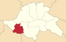
Akhalkalaki uezd
Akhalkalaki Uyezd
Ахалкалакский уезд/округ | |
|---|---|
 Location in the Tiflis Governorate | |
| Land | Russian Empire |
| Governorate | Tiflis |
| Viceroyalty | Caucasus |
| Established | 1874 |
| Abolished | 1930 |
| Seat | Akhalkalaki |
| Uchastoks | Baralet, and Bogdanov |
| Area | |
| • Total | 2,739 km2 (1,058 sq mi) |
| Population (1916) | |
| • Total | 107,173 |
| • Density | 39/km2 (100/sq mi) |
The Akhalkalaki Uyezd (Russian: Ахалкалакский уезд; Georgian: ახალქალაქის მაზრა; Armenian: Ախալքալաքի գավառ) was a uezd (county) of the Tiflis Governorate of the Caucasus Viceroyalty of the Russian Empire, and then of Democratic Republic of Georgia, with its administrative center in Akhalkalaki.[1][2] The uyezd bordered the Gori Uyezd to the north, the Borchaly Uyezd to the east, the Alexandropol Uezd of the Erivan Governorate and the Kars and Ardahan okrugs of the Kars Oblast to the south, and the Akhaltsikhe Uyezd to the west. The area of the uyezd roughly corresponded to the contemporary Samtskhe-Javakheti region of Georgia.
History
The territory of the Akhalkalaki Uyezd, then part of the Akhaltsikhe Uyezd, entered into the Kutais Governorate of the Russian Empire following the Russo-Turkish War of 1828. By 1874, the Akhkalaki Uyezd was detached from the hitherto larger Akhaltsikhe Uyezd, becoming a constituent county of the Tiflis Governorate.
Following the Russian Revolution, the Akhalkalaki Uyezd was incorporated into the short-lived Democratic Republic of Georgia.
Administrative divisions
The uchastoks (sub-counties) of the Akhalkalaki Uyezd were:[3]
Demographics
Caucasian Calendar of 1917
The 1917 Caucasian Calendar which produced statistics of 1916 indicates 107,173 residents in the Akhalkalaki Uyezd, including 56,140 men and 51,033 women, 106,307 of whom were the permanent population, and 866 were temporary residents:[4]
| Nationality | Zentrum | Rural | TOTAL | |
|---|---|---|---|---|
| Armenians | 6,151 | 76,624 | 82,775 | 77.2% |
| Georgians | 265 | 10,039 | 10,304 | 9.6% |
| Russians | 429 | 7,113 | 7,542 | 7.0% |
| Azerbaijanis | 0 | 5,431 | 5,431 | 5.1% |
| Kurds | 0 | 904 | 904 | 0.8% |
| Jews | 204 | 0 | 204 | 0.2% |
| TOTAL | 7,055 | 100,118 | 107,173 | 100.0% |
See also
References
- ^ Brockhaus and Efron Encyclopaedia: Tiflis Governorate (in Russian)
- ^ Tsutsiev, Arthur (2014), Atlas of the Ethno-Political History of the Caucasus, New Haven and London, p. 164, ISBN 978-0-300-15308-8, OCLC 884858065, retrieved 2021-12-25
{{citation}}: CS1 maint: location missing publisher (link) - ^ Кавказский календарь .... на 1913 год (in Russian). Tiflis: Office of the Viceroy of the Caucasus. 1913. pp. 271–317.
- ^ Кавказский календарь .... на 1917 год (in Russian). Tiflis: Office of the Viceroy of the Caucasus. 1917. pp. 363–366.

