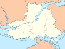
Khreshchenivka
Appearance
Khreshchenivka
Хрещенівка | |
|---|---|
| Coordinates: 47°23′07″N 33°49′18″E / 47.385278°N 33.821667°E | |
| Land | Ukraine |
| Province | Kherson Oblast |
| District | Beryslav Raion |
| Gegründet | 1821 |
| Area | |
| • Total | 197.5 km2 (76.3 sq mi) |
| Elevation | 82 m (269 ft) |
| Population | |
| • Total | 737 |
| • Density | 3.7/km2 (9.7/sq mi) |
| Time zone | UTC+2 (EET) |
| • Summer (DST) | UTC+3 (EEST) |
| Postal code | 74213 |
| Area code | +380 5533 |
 | |
Khreshchenivka (Ukrainian: Хрещенівка; Russian: Крещеновка) is a village in the Beryslav Raion of Kherson Oblast in southern Ukraine, about 127 kilometres (79 mi) north-east of the centre of Kherson city.
The village came under attack by Russian forces during Russian invasion of Ukraine in 2022.[1]
Demographics
Native language distribution as of the Ukrainian Census of 2001:[2]
- Ukrainian: 95.90.81%
- Russian: 3.21%
- Belarusian: 0.38%
- Bulgarian: 0.13%
- Moldavian: 0.13%
- Polish: 0.13%
References
- ^ "Enemy deploys up to 22 BTGs near Izium - General Staff". ukrinform.net. 16 April 2022. Retrieved 14 June 2022.
In the Southern Buh direction, the enemy's actions were characterized by measures to restore combat readiness, replenish reserves, fortify positions outside the settlements of Liubymivka, Petrivka, Khreshchenivka /.../
- ^ Розподіл населення за рідною мовою на ukrcensus.gov.ua


