Antakalnis
It has been suggested that this article should be split into a new article titled Antakalnis Eldership. (discuss) (January 2021) |
Antakalnis | |
|---|---|
 Aerial view of Antakalnis | |
| Coordinates: 54°45′24″N 25°22′03″E / 54.75667°N 25.36750°E | |
| Country | |
| County | |
| Municipality | Vilnius city municipality |
| Area | |
| • Total | 77.2 km2 (29.8 sq mi) |
| Population (2021)[1] | |
| • Total | 39,257 |
| • Density | 510/km2 (1,300/sq mi) |
| Time zone | UTC+2 (EET) |
| • Summer (DST) | UTC+3 (EEST) |


Antakalnis (literally Lithuanian: 'the place on hills', adapted in Polish: Antokol[2]) is an eldership in the Vilnius city municipality, Lithuania. Antakalnis is one of the oldest, and largest historical suburbs of Vilnius City. It is in the eastern section of Vilnius, along the left bank of the Neris River, with the river running along the whole western side of the district.[3] The Antakalnis eldership is the second-largest in Vilnius, with an area of 77.2 km2 (29.8 sq mi).
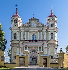
One of the greatest Lithuanian Baroque masterpieces, the Roman Catholic Church of St. Peter and St. Paul, is in Antakalnis, as is Sapieha Palace (Sapiegų rūmai). Sapieha Palace is surrounded by the only surviving Baroque-style park in Lithuania, which contains the oldest linden tree in Vilnius.
Antakalnis is home to the historically important Antakalnis Cemetery, where victims of the January Events in 1991, killed by the Soviet Army, are buried; their graves are often visited, as they are considered national heroes of Lithuania.
Antakalnis eldership includes the recreational area and prestigious cottage district Valakampiai, where two river beaches have been established. The current and former president of Lithuania, the prime minister of Lithuania, and other state officials reside in the Turniškės neighborhood of Antakalnis.
The Botanical Garden of Vilnius University lies in Kairėnai, the settlement in the eastern part of the district.
The Jewish surnames Antokolec, Antokolsky and variants derive from the Polish pronunciation of the district's name.
History
Antakalnis is one of the oldest parts of Vilnius. Historically, the suburb of Antakalnis developed along a road to Aukštaitija and Viršupis, the summer palace of the grand dukes.[4]
Areas
Antakalnis eldership includes these city parts: Aukštagiris, Aukštieji Karačiūnai, Antakalnis, Antaviliai, Baniškės, Didieji Pupojai, Dvarčionys, Galgiai, Gvazdikai, Kalnai, Kairėnai, Liepynė, Mažieji Pupojai, Meiriškės, Mileišiškės, Pečiukai, Pylimėliai, Sapieginė, Saulėtekis, Smėlynė, Šilas, Šilėnai, Turniškės, Vaguva, Valakampiai, Aukštoji Veržuva, Žemoji Veržuva, Vinciūniškės, Vismalai, Vismaliukai, Vyriai, Žemieji Karačiūnai.
Tourist Attractions
- Pavilniai Regional Park
- Antakalnis Park of Benches
- UNO Park Vilnius
- Colorful Springs
Famous people
Famous Lithuanians having lived in Antakalnis eldership:
- Valdas Adamkus, former President of Lithuania
- Mark Antokolski, sculptor
- Algirdas Brazauskas, former president and Prime Minister of Lithuania
- Janina Degutytė, poet
- Vytautas Kernagis, actor and composer
- Andrius Kubilius, former Prime Minister of Lithuania
- Andrius Mamontovas, a rock singer
- Virgilijus Noreika, an opera singer
- Rolandas Paksas, former President of Lithuania
- Paulius Širvys, poet
- Sofija Veiverytė, artist/painter
- Ingrida Šimonytė, former Minister of Finance and Prime Minister of Lithuania
- Jurga Ivanauskaitė, writer
Twin towns
References
- ^ gyventojų ir būstų surašymas
- ^ Stravinskienė, Vitalija (2015). "The Territorial expansion of Vilnius: plans and their realisation (1916-1940)". Lithuanian Historical Studies. 20. Lithuanian Institute of History: 131, 133. ISSN 1392-2343.; "Vilnius". Encyclopædia Britannica: A New Survey of Universal Knowledge. Vol. 23. Encyclopædia Britannica Inc. 1964. p. 166. Archived from the original on 2022-06-29. Retrieved 2021-06-29.
- ^ (in Lithuanian) "Vilniaus mikrorajonas Antakalnis" Archived 2015-09-01 at the Wayback Machine Antakalnis eldership official website. Retrieved 25 September 2013.
- ^ Vykintas Vaitkevičius. Neris. 2007 metų ekspedicija. Trečia knyga. Vilnius: Mintis, 2013.
External links
- (in Lithuanian) Antakalnis photogallery
- (in English) Visitor's guide to Antalkalnis Cemetery

