
Fethiye
This article needs additional citations for verification. (November 2021) |
Fethiye | |
|---|---|
.jpg) Aerial view of Fethiye | |
|
Emblem of Fethiye Municipality | |
 Location of Fethiye within Turkey | |
 Fethiye  Fethiye | |
| Coordinates: 36°39′5″N 29°7′23″E / 36.65139°N 29.12306°E | |
| Land | |
| Region | Mediterranean |
| Province | Muğla |
| Regierung | |
| • Mayor | Alim Karaca[1] (CHP) |
| Area | |
| • District | 2,955.08 km2 (1,140.96 sq mi) |
| Population | |
| • Urban | Template:Turkey district populations |
| • District | Template:Turkey district populations |
| Time zone | UTC+3 (FET) |
| Postal code | 48x xx |
| Area code | 00 (90) 252 |
| Licence plate | 48 |
| Website | www.fethiye.bel.tr www.fethiye.gov.tr |
Fethiye (Turkish pronunciation: [ˈfethije]) is a city and district of Muğla Province in the Mediterranean Region of Türkei. It is one of the prominent tourist destinations in the Turkish Riviera. In 2019 its population was 162,686.[3]
History

Fethiye was formerly known as Makri (Greek: Μάκρη).[4][5] Modern Fethiye is located on the site of the ancient city of Telmessos, the ruins of which can be seen in the city, e.g. the Hellenistic theatre by the main quay.
A Lycian legend explains the source of the name Telmessos as follows: The god Apollo falls in love with the youngest daughter of the King of Phoenicia, Agenor. He disguises himself as a small dog and thus, gains the love of the shy, withdrawn daughter. After he reappears as a handsome man, they have a son, who they name 'Telmessos' (the land of lights).[citation needed]
The city became part of the Persian Empire after the invasion of the Persian general Harpagos in 547 BC, along with other Lycian and Carian cities. Telmessos then joined the Attic-Delos Union (Delian League) established in mid-5th century BC. and, although it later left the union and became an independent city, it continued its relations with the union until the 4th century BC. [citation needed]

Very little is known of the city during the Byzantine times. Surviving buildings attest to considerable prosperity during late Antiquity, but most were abandoned in the 7th–8th centuries due to the Arab-Byzantine Wars. [citation needed] The city was fortified in the 8th century, and appears as "Telmissos or Anastasioupolis" ca. 800. By the 10th century, the ancient name was forgotten and it became known as Makre or Makri (Μάκρη, "long one"), from the name of the island at the entrance to the harbour.[4] There are signs of renewed prosperity in the 12-13th centuries: the city walls were enlarged, a report from 1106 names Makre a centre for perfume production, and geographical works from the 13th century describe the city as a commercial center. The area fell to the Turks in the late 12th or early 13th century.[5]
Telmessos was ruled by the Anatolian beylik of Menteşe starting in 1284, under the name Beskaza.
It became part of the Ottoman Empire in 1424, and was called مكرى Meğri until 1934.[6]
From 1867 until 1922, Meğri was part of the Aidin Vilayet of the Ottoman Empire. The town grew considerably in the 19th century, and had a large Greek population at that time.[4] Following the population exchange between Greece and Turkey, the Greeks of Makri were sent to Greece where they founded the town of Nea Makri (New Makri) in Greece.[4] The town was resettled with Turks from Greece. At nearby Kayaköy, formerly Levissi, the abandoned Greek Orthodox church is still standing.[citation needed]
In 1934, the city was renamed Fethiye in honor of Captain Fethi Bey, one of the first pilots of the Ottoman Air Force, who died (together with First Lieutenant Sadık Bey) during an airplane crash on 27 February 1914 near Al-Samra, while attempting to complete the first flight from Istanbul to Cairo.[7]
On 3 August 1953, Air France Flight 152, while en route from Rome to Beirut, ditched into the Gulf of Fethiye off Kızılada. Of the 8 crew and 34 passengers on board, four drowned. The survivors were hosted by the residents during their stay in the town.[8][9][10]
Fethiye has experienced many powerful and occasionally destructive earthquakes, most notably the 1957 Fethiye earthquakes on 24–25 April with 67 casualties and 3,200 damaged or destroyed buildings, which constituted 90% of the buildings in the entire city.[11] The town has been rebuilt since then and now has a modern harbor and a marina.
On 14 January 1969, Fethiye was struck by an earthquake with a magnitude of 6.2, which caused no deaths, but there were some injuries and significant damage to buildings.[12]
On 10 June 2012, an earthquake with a magnitude of 6.1, struck Fethiye. There was no loss of life, but there were some injuries and many houses and workplaces were damaged.[13]
Tourism
Fethiye is one of Turkey's well-known tourist centers and is especially popular during the summer. The Fethiye Museum, which is rich in ancient and more recent artifacts, displays and testifies to the successive chain of civilizations that existed in the area, starting with the ancient Lycians.
Some of the historical sites worth visiting are: Kadyanda (Cadyanda) ancient city, Kayaköy - the abandoned Greek village, Afkule, Gemiler and Aya Nikola. Fethiye is also home to the Tomb of Amyntas, a large tomb built in 350 BC by the Lycians.[14]
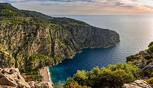
Most popular touristic towns of Fethiye are: Ölüdeniz, Calis Beach area, Hisarönu and Ovacık,_Fethiye.[15] Butterfly Valley is in the Fethiye district.
The island of Kızılada in the Gulf of Fethiye, 4 mi (6.4 km) off the city,[16] is a popular stopover for boat tours. Alternatively, there are great diving sites, Afkule being one of the most famous.[17] The Kızılada Lighthouse on the island houses a seafood restaurant and a hostel with nine rooms.[18]
-
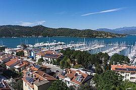 Marina of Fethiye
 -
 Fethiye bay
 -
 The Tomb of Amyntas in Fethiye.
 -

-
 Butterfly Valley is a popular tourism destination in Fethiye District
 -
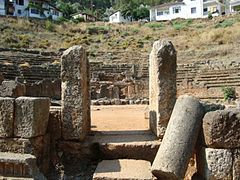 Telmessos Theatre – the sign on site says it was late Hellenistic, with stage added in c. 200 AD, abandoned with the city, excavated in 1992–95, and with seating capacity for 6,000 spectators on 28 rows.


.jpg)

Gallery
-
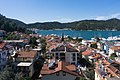 A view from central Fethiye
 -
 Fethiye Museum Ceramic
 -
 Gold ceremonial bowl
 -
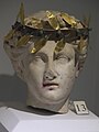 Gold laurel wreath
 -
 Bilingual inscription
 -
 Dolls
Dolls -
 Kakasbos
 -
 Lagynos
 -
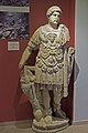 Hadrian statue
 -
 Girl statue
 -
 Letoon temple floor decoration
 -
 Lycian rock tomb in Fethiye (4th century BCE)


Climate
Fethiye has a Mediterranean climate consisting of hot, long and dry summers with an average of 34 °C (93 °F) in the daytime, winters are mild and rainy with a daytime average of 16 °C (61 °F). The classification for the climate of Fethiye is Csa (Köppen)[19] and Csal (Trewartha)[20]
| Climate data for Fethiye | |||||||||||||
|---|---|---|---|---|---|---|---|---|---|---|---|---|---|
| Month | Jan | Feb | Mar | Apr | May | Jun | Jul | Aug | Sep | Oct | Nov | Dec | Year |
| Mean daily maximum °C (°F) | 16.0 (60.8) |
16.3 (61.3) |
18.9 (66.0) |
22.0 (71.6) |
26.4 (79.5) |
31.4 (88.5) |
34.3 (93.7) |
34.4 (93.9) |
31.3 (88.3) |
26.5 (79.7) |
21.1 (70.0) |
17.2 (63.0) |
24.7 (76.4) |
| Mean daily minimum °C (°F) | 5.3 (41.5) |
5.7 (42.3) |
7.2 (45.0) |
10.1 (50.2) |
13.8 (56.8) |
17.6 (63.7) |
20.3 (68.5) |
20.2 (68.4) |
16.9 (62.4) |
13.1 (55.6) |
9.1 (48.4) |
6.6 (43.9) |
12.2 (53.9) |
| Average precipitation mm (inches) | 159.8 (6.29) |
128.4 (5.06) |
80.1 (3.15) |
49.0 (1.93) |
25.8 (1.02) |
4.8 (0.19) |
3.1 (0.12) |
2.6 (0.10) |
17.6 (0.69) |
66.7 (2.63) |
123.3 (4.85) |
174.1 (6.85) |
835.3 (32.88) |
| Average rainy days | 12.1 | 11.3 | 9.0 | 8.0 | 4.4 | 2.2 | 1.4 | 1.6 | 2.5 | 5.7 | 8.3 | 12.1 | 78.6 |
| Mean monthly sunshine hours | 145.7 | 156.8 | 213.9 | 237.0 | 300.7 | 342.0 | 359.6 | 344.1 | 294.0 | 244.9 | 165.0 | 127.1 | 2,930.8 |
| Source: Devlet Meteoroloji İşleri Genel Müdürlüğü[21] | |||||||||||||
Transport
Dalaman Airport serves the Fethiye areas. The most common type of public transportation in Fethiye and nearby area is minibus. It is called here dolmus (dol-moosh) and numerous routes connect Fethiye with Ölüdeniz, Yaniklar, Kargi, Hisaronu, Ovacik, Seydikemer, Karaçulha.[22]
Areas
The overall metropolitan area of the city of Fethiye stretches inland from the harbor for more than 11 km, incorporating several villages into the city. To the north of the city center is the area of Çalış Plajı (Beach), which incorporates the main street of Barış Manço Bulvarı alongside an extensive promenade along the coast, on which a lot of hotels are based. This beach serves as Fethiye's beach in its own right, since Fethiye does not actually have one itself. To the east, lie the areas of Günlükbaşı, Çamköy, Cumhuriyet, and also Esenköy to the south-east. The city center is defined as the area between the Marina and the Fethiye Market near the football stadium. Approximately 4 km to the south-west and south respectively, lie the towns of Kayaköy and Ölüdeniz, the latter being world-famous for its beach spit and associated Blue Lagoon. The opportunity to para glide is available from the mountain of Babadağ next to Ölüdeniz.
See also
References
- ^ "2019 Muğla Fethiye Election Results - Turkey's March 31 Local Elections". Archived from the original on 5 April 2019.
- ^ "Area of regions (including lakes), km²". Regional Statistics Database. Turkish Statistical Institute. 2002. Retrieved 5 March 2013.
- ^ "Population of Fethiye district in Muğla Province". nufusu.com. Retrieved 21 June 2020.
- ^ a b c d Diana Darke, Guide to Aegean and Mediterranean Turkey, M. Haag, 1986, 296 pages. Page 165, The town grew considerably at the end of the 19th century, and until the exchange of Greco-Turkish populations in 1923 it had a large Greek population. Its name at that time was Makri in modern Greek.
- ^ a b Foss ", Clive; Kazhdan, Alexander P. (1991). "Makre". In Kazhdan, Alexander P. (ed.). Oxford Dictionary of Byzantium. New York; Oxford: Oxford University Press. pp. 1271–1272. ISBN 978-0-19-504652-6.
- ^ Tahir Sezen, Osmanlı Yer Adları, Ankara 2017, T.C. Başbakanlık Devlet Arşivleri Genel Müdürlüğü Yayın No: 26 s.v. Fethiye, Meğri, pp. 270, 539
- ^ Letter from Kibbutz Ha’On: Fallen Flyers Hadassah Magazine, 17 March 2014
- ^ "F-BAZS – Constellation Air France" (in French). Avio Techno. Retrieved 13 January 2016.
- ^ "Rapport d'Enquête sur l'accident survenu à Fethiye (Turquie) le 3 aoǜt 1953, à l'avion Lockheed 749 A – F.BAZS, de la Compagnie Air France" (PDF). Journal Officiel de la République Française (in French): 149–154. 16 March 1954. Retrieved 13 January 2016.
- ^ Selener, Necdet (31 August 1953). "Fethiye açıklarında denize inen Fransız yolcu uçağı". Milliyet (in Turkish). Retrieved 13 January 2016.
- ^ "Significant Earthquakes in Turkey, 1947 – 1970". Boğaziçi University, Kandilli Observatory and Earthquake Research Center, Istanbul – Turkey. Retrieved 25 February 2011.
- ^ "Fethiye ilçesinin deprem durumu" (in Turkish). www.erdemyerbilimleri.com.tr. Archived from the original on 1 December 2018. Retrieved 14 October 2021.
- ^ "Akdeniz'de 6.1 şiddetinde deprem" (in Turkish). Archived from the original on 2 January 2019. Retrieved 20 December 2014.
- ^ Berens, Kallie. "Fethiye Tomb in the Mountainside". Mysendoff.com. mysendoff.com. Archived from the original on 21 October 2011. Retrieved 19 October 2011.
- ^ "Places to visit in Fethiye". Archived from the original on 20 October 2018. Retrieved 19 March 2014.
- ^ "Kızıl Ada Yeşile Bürünecek". Haberler (in Turkish). 11 January 2014. Retrieved 16 January 2016.
- ^ "Fethiye-Ölüdeniz-Kızılada-Fethiye". Hürriyet (in Turkish). Retrieved 16 January 2016.
- ^ "Kızıl Ada'nın feneri, gezgin midelerin yeni gözdesi oldu". Sabah (in Turkish). 30 September 2007. Retrieved 16 January 2016.
- ^ Meteocorne [1]
- ^ Meteocorne [2]
- ^ İl ve İlçelerimize Ait İstatistiki Veriler- Meteoroloji Genel Müdürlüğü. Dmi.gov.tr. Retrieved on 16 April 2011. Archived 10 October 2011 at the Wayback Machine
- ^ Getting around in Fethiye, The advantages and disadvantages of most popular ways of getting around in Fethiye and area nearby.
External links
Fethiye in Muğla Province of Turkey | |||||||||||||||||||||||||||
|---|---|---|---|---|---|---|---|---|---|---|---|---|---|---|---|---|---|---|---|---|---|---|---|---|---|---|---|
| Districts |   | ||||||||||||||||||||||||||
|
Metropolitan municipalities are bolded. | |||||||||||||||||||||||||||
| International | |
|---|---|
| National | |
- Fethiye
- Cities in Turkey
- Populated coastal places in Turkey
- Mediterranean port cities and towns in Turkey
- Turkish Riviera
- Populated places in Muğla Province
- Mediterranean Region, Turkey
- Districts of Muğla Province
- Ancient Greek archaeological sites in Turkey
- Greece–Ottoman Empire relations
- Greece–Turkey relations
- Former Greek towns in Turkey