
Rio Grande
The Rio Grande (known in Mexico as the Río Bravo del Norte, or simply Río Bravo) is a river that forms part of the border between the United States and Mexico. At 1,885 miles (3,034 km) long, it is the fourth-longest river system in the United States.[1] It serves as a natural boundary along the border between the American state of Texas and the Mexican states of Chihuahua, Coahuila, Nuevo León, and Tamaulipas as well as a very small stretch with fellow American state New Mexico between Doña Ana County, New Mexico and El Paso County, Texas.
Geography
The Rio Grande rises in the eastern part of the Rio Grande National Forest in the American state of Colorado. This river is formed by the joining of several streams at the base of Canby Mountain, just east of the Continental Divide. From there, it flows through the San Luis Valley, then south into the state of New Mexico and passes through Espanola, Albuquerque and Las Cruces to El Paso, Texas, where it begins to form the natural border between the United States and Mexico. A major tributary, the Río Conchos, enters at Ojinaga, Chihuahua, below El Paso, and supplies most of the water in the 1,254 miles (2,018 km) Texas border segment. Other well-known tributaries include the Pecos and the smaller Devils, which join the Rio Grande on the site of Amistad Dam. Despite its name and length, the Rio Grande is not navigable by ocean-going ships, nor do smaller passenger boats or cargo barges use it as a route. In fact it is barely navigable at all, except by small fishing boats. The natural flow of the Rio Grande is only 1/4 the volume of that of the Colorado River,[2][3] and less than 1/50 that of the Mississippi River.
The Rio Grande rises in high mountains and flows for much of its length at high elevation; El Paso is 3,762 feet (1,147 m) above sea level. In New Mexico, the river flows through the Rio Grande Rift from one sediment-filled basin to another, cutting canyons between the basins and supporting a fragile bosque ecosystem in its floodplain. From El Paso eastward, the river flows through desert. Only in the sub-tropical lower Rio Grande Valley is there extensive irrigated agriculture. The river ends in a small sandy delta at the Gulf of Mexico. Due to extended dry weather, the river has only occasionally emptied into the Gulf of Mexico since 2002.[4]
Millions of years ago, the Rio Grande ended at the bottom of the Rio Grande Rift in Lake Cabeza de Vaca. About one million years ago (mya), the stream was "captured" and began to flow east.
History

The river was the border which the Republic of Texas used between it and Mexico, but Mexico considered the border to be the Nueces River. The disagreement provided the excuse for the US invasion of Mexico in 1848, after Texas had been admitted as a state. Since 1848, the Rio Grande has marked the boundary between Mexico and the United States from the twin cities of El Paso, Texas, and Ciudad Juárez, Chihuahua, to the Gulf of Mexico. As such, crossing the river was the escape route used by some Texas slaves to seek freedom. Mexico had liberal colonization policies and had abolished slavery in 1828.[5]
In 1997 the US designated the Rio Grande as one of the American Heritage Rivers.
In the summer of 2001, a 328-foot (100-meter) wide sandbar formed at the mouth of the river, marking the first time in recorded history that the Rio Grande failed to empty into the Gulf of Mexico. The sandbar was subsequently dredged, but it re-formed almost immediately. Spring rains the following year flushed the re-formed sandbar out to sea, but it returned in the summer of 2002. As of September 2006, the river once again reaches the Gulf.
River modifications

The United States and Mexico share the water of the river under a series of agreements administered by the joint US-Mexico Boundary and Water Commission. The most notable of these treaties were signed in 1906 and 1944.[6][7]
Use of that water belonging to the United States is regulated by the Rio Grande Compact, an interstate pact between Colorado, New Mexico, and Texas. The water of the Rio Grande is over-appropriated: that is, there are more users for the water than there is water in the river. Because of both drought and overuse, the section from El Paso downstream through Ojinaga was recently tagged "The Forgotten River" by those wishing to bring attention to the river's deteriorated condition. [8]
The major international border crossings along the river are at Ciudad Juárez and El Paso; Presidio, Texas, and Ojinaga, Chihuahua; Laredo, Texas, and Nuevo Laredo, Tamaulipas; McAllen-Hidalgo, Texas, and Reynosa, Tamaulipas; and Brownsville, Texas, and Matamoros, Tamaulipas. Other notable border towns are the Texas/Coahuila pairings of Del Rio–Ciudad Acuña and Eagle Pass–Piedras Negras.
-
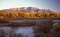 The Rio Grande at Bernalillo, New Mexico, with the Sandia Mountains
 -
 The Rio Grande flowing in Big Bend National Park.
 -
 The Rio Grande in its lower course, between Matamoros (right) and Brownsville (left)


Names and pronunciation

Río Grande is Spanish for "Big River" and Río Grande del Norte means "Great River of the North". In English, Rio Grande is pronounced either /ˈriːoʊ ˈɡrænd/ or /ˈriːoʊ ˈɡrɑːndeɪ/. Because "río" means "river" in Spanish, the phrase "Rio Grande River" is redundant.
In Mexico it is known as Río Bravo or Río Bravo del Norte, "bravo" meaning "fierce" or "brave". A city on its banks in Mexico bears its name (Río Bravo, Tamaulipas) and is located 10 miles (16 km) east of Reynosa, Tamaulipas, and directly across from the Texas city of Donna.
Historically, the Pueblo and Navajo peoples also had names for the Rio Grande/Rio Bravo:
- mets'ichi chena, Keresan, "Big River"
- posoge, Tewa, "Big River"
- paslápaane, Tiwa, "Big River"
- [hañapakwa] Error: {{Lang}}: text has italic markup (help), Towa, "Great Waters"
The four Pueblo names likely predated the Spanish entrada by several centuries.[9]
- [tó ba-ade] Error: {{Lang}}: text has italic markup (help), Navajo, "Female River" (the direction south is female in Navajo cosmology) [9]
Rio del Norte was most commonly used for the upper Rio Grande (roughly, within the present-day borders of New Mexico) from Spanish colonial times to the end of the Mexican period in the mid-19th century. This use was first documented by the Spanish in 1582. Early American settlers in south Texas began to use the modern 'English' name Rio Grande. By the late 19th century, in the United States, the name Rio Grande had become standard in being applied to the entire river, from Colorado to the sea.[9]
By 1602, Rio Bravo had become the standard Spanish name for the lower river, below its confluence with the Rio Conchos.[9]
Sources
- Paul Horgan, Great River: The Rio Grande in North American History. Volume 1, Indians and Spain. Vol. 2, Mexico and the United States. 2 Vols. in 1, 1038 pages - Wesleyan University Press 1991, 4th Reprint, ISBN 0-8195-6251-3
See also
- Rio Bravo, Texas
- US-Mexico Border
- Rio Grande border disputes
- List of crossings of the Rio Grande
- List of Colorado rivers
- List of New Mexico rivers
- List of Texas rivers
- Rio Grande Wild and Scenic River
- Rio Grande Valley
- Rio Grande Gorge
- Rio Grande Trail
- Rio Grande Project
References
- ^ J.C. Kammerer (May 1990). "Largest Rivers in the United States". United States Geological Survey. Retrieved 2006-07-15.
{{cite journal}}: Cite journal requires|journal=(help) - ^ Colorado
- ^ Rio Grande
- ^ Google Satellite Map of Rio Grande and surrounding area
- ^ "The UGRR on the Rio Grande"
- ^ IBWC: Treaties Between the U.S. and Mexico
- ^ Thompson, Olivia N., "Binational Water Management: Perspectives of Local Texas Officials in the U.S.-Mexico Border Region" (2009). Applied Research Projects. Texas State University. Paper 313. http://ecommons.txstate.edu/arp/313
- ^ "Rio Grande Sucked Dry for Irrigation, Industry", CNN SATURDAY MORNING NEWS, (Aired June 9, 2001)]
- ^ a b c d Source for historical names: Carroll L. Riley, 1995, Rio del Norte, University of Utah Press. ISBN 0874804965
External links
- Border Stories: the only hand pulled ferry on the Rio Grande (video)
- Rio Grande from the Handbook of Texas Online
- 1854 map of Rio Grande entrance (hosted by the Portal to Texas History).
- Rio Grande Cam - in Mission Texas. Mexico is on the left and the US is on the right.
- Bibliography on Water Resources and International Law Peace Palace Library
- U.S. Geological Survey Geographic Names Information System: Rio Grande