
Cap-Haïtien
Cap-Haïtien
Kapayisyen, Okap | |
|---|---|
 | |
| Land | Haiti |
| Department | Nord |
| Arrondissement | Cap-Haïtien |
| Regierung | |
| • Mayor | Michel St Croix |
| Elevation | 0 m (0 ft) |
| Population (8 August 2005)[1] | |
| • Total | 200,251 |
| Time zone | UTC-5 (Eastern) |
| • Summer (DST) | UTC-4 (Eastern) |
| Sister cities[2] |
|---|
Cap-Haïtien (Okap or Kapayisyen in Kréyòl) is a city of about 190,000 people on the north coast of Haiti. Previously, named as Cap-Français and Cap-Henri, it was an important city during the colonial period and was the first capital of the Kingdom of Northern Haiti under King Henri Christophe.
Cap-Haïtien's distance from Haïti's capital, Port-au-Prince, combined with the dire condition of Haïti's transportation infrastructure, has often made Cap-Haïtien an incubator for revolutionary or Anti-Government figures. On February 5–29, 2004, the city was taken over by militants who opposed to the rule of Haïtian president Jean-Bertrand Aristide, forcing him out from the country.
The central area of the city is located between the Bay of Cap-Haïtien to the east, and nearby mountainsides to the west, which are increasingly dominated by flimsy urban slums. The streets are generally narrow and arranged in grids. As a legacy of the U.S. occupation of Haïti from 1915–1934, Cap-Haïtien's north-south streets were renamed as single letters (beginning with Rue A, a major avenue), and its east-west streets with numbers. This system breaks down outside of the central city, which is itself dominated by numerous markets, churches, and low-rise apartment buildings (3–4 floors each) constructed primarily before and during the U.S. occupation. Many such buildings have balconies on the upper floors which overlook the narrow streets below, creating an intimate communal atmosphere during the Haitian dinner hours.
Cap-Haïtien is the city of the historic Haïtian town of Milot, which lies 12 miles to the southwest along a gravel road. Milot was Haïti's first site capital under the self-proclaimed King Henri Christophe, who ascended to power in 1807, three years after Haïti had gained independence from France, renaming the city as Cap-Henri. As a result, Milot hosts the ruins of the Sans-Souci Palace, wrecked by the 1842 earthquake, as well as the Citadelle Laferrière, a massive stone fortress bristling with cannons. The Citadelle is located five miles from Milot, atop a nearby mountain. On clear days, its silhouette is visible from Cap-Haitien.
The small Cap-Haitien International Airport, located on the southeast edge of the city, is currently served by several small domestic airlines, and is patrolled by Chilean UN troops. International service to Ft. Lauderdale, Florida is provided by Lynx Air International. The city hosts several hundred UN personnel as part of the ongoing United Nations Stabilization Mission in Haiti (MINUSTAH).
Economy
Cap-Haïtien is known as the nation's largest center of Historic monuments and Tourism Finance. from its calm water and picturesque Caribbean beaches, to its Citadelle Laferiere one of the Great Wonders of the World have made it a resort and vacation destination for Haïti's upper classes, comparable to Pétionville. Cap-Haïtien has, in general, also seen greater foreign tourist activity than much of Haiti, due to its isolation from political instability. Cap-Haïtien is also unique for its French colonial architecture, which has been uniquely well preserved. After the Haitian Revolution, many craftsmen from Cap-Haïtien fled to French-controlled New Orleans, as a result, the two cities share many similarities in styles of architecture. Especially notable are the many gingerbread houses lining the city's older streets.

Labadie
The walled Labadie beach resort compound is located six miles to the city's northwest, and has served as a brief stopover for Royal Caribbean cruise ships. Today, major Royal Caribbean Cruise ships, including the largest and most luxurious (Oasis of the Seas), dock weekly at Labadie. It is a private resort leased by Royal Caribbean International. Royal Caribbean International has contributed the largest proportion of tourist revenue to Haiti since 1986, employing 300 locals, allowing another 200 to sell their wares on the premises, and paying the Haitian government US$6 per tourist. The resort is connected to Cap-Haïtien by a mountainous dirt and gravel road. RCI has built a pier at Labadie capable of servicing the Oasis class ships, completed in late 2009, no longer requiring passengers to be tendered from anchored ships.[3] Attractions include a Haitian flea market, numerous beaches, watersports, a water-oriented playground, and the popular zip-line.[4]
Vertières
Vertières is the site of the Battle of Vertières - the last and defining battle of the Haitian Revolution. On November 18, 1803, Haitian rebels led by Jean-Jacques Dessalines defeated a French colonial army led by the Comte de Rochambeau, leading to the independence of Haïti. It is also the site that made Capois La Mort famous for his bravery. In the last battle for the Independence he survived all the French bullets that nearly killed him; his horse was killed underhim and his hat fell off but he kept on marching on the French while screaming "En avant!" which means "Let's go forward". As a result, the independent Republic of Haiti was proclaimed on 1 January 1804. 18 November has been widely celebrated since then as a Day of Army and Victory in Haiti.

Citadelle Laferrière
The Citadelle Laferrière or, Citadelle Henri Christophe, or simply the Citadelle, is a large mountaintop fortress located approximately 17 miles (27 km) south of the city of Cap-Haïtien and five miles (8 km) beyond the town of Milot. It is the largest fortress in the Americas and was listed by UNESCO as a World Heritage Site in 1982—along with the nearby Sans-Souci Palace. The Citadel was built by Henri Christophe, a leader during the Haitian slave rebellion and subsequently King of Northern Haiti, after the country gained its independence from France at the beginning of the 19th century.
2010 Haiti Earthquake
In the wake of the 2010 Haiti earthquake which destroyed port facilities in Port-au-Prince, Cap-Haïtien's container port was being used to deliver relief supplies [5].
Since the city in general was not as affected in is infrastructure as Port-au-Prince, former Port-au-Prince businessmen and many people have moved to Cap Haitian.
Few damages have been reported as consequence of the 2010 earthquake, such as the collapse of a school classroom that killed 4 children and injured 1.
Higher education
A union of 4 Congregational Church Private Schools have been Present for Two decades in Cap-Haitien. They are considered as higher education establishment the mainstream framework of the Public school system. also known as École Normale Supérieure outside, The term is most commonly used to refer of Academic Excellence, Selectivity in Admissions, and Social Elitism.
- College Notre-Dame du Perpetuels Secours des Peres de Sainte-Croix
- Ecole des Freres De L'instruction Chretienne
- Ecole Saint Joseph De Cluny des Soeurs Anne-Marie Javoue
- College Regina Assumpta des Soeurs de Sainte-Croix
- college Martin Luther King
- College Pratique du Nord
Notable natives
Tyrone Edmond, Haitian-born model.
Gallery
-
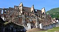 Front view of Sans-Souci Palace
 -
 Cap Haitien's City Council. (Not a hotel)
 -
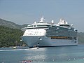 A Cruise ship at Labadee.


Television
Media
- Radyo Atlantik, 92.5 FM [8]
- Radio 4VEH (4VEF), 840 AM [9]
- Radio 4VEH, 94.7 FM [10]
- Radio 7 FM, 92.7 [11]
- Radio Cap-Haïtien
- Radio Citadelle
- Radio Étincelle
- Radio Gamma, 99.7 (Based in Fort Liberté) [12]
- Radio Lumiere, 98.1 FM [13]
- Radio Méga,103.7 FM
- Radio Sans-Souci FM, 106.9
- Radio VASCO, 93.7 FM [14]
- Radio Vénus FM
- Sans Souci FM, 106.9 [15]
- Voix de l’Ave Maria
- Voix du Nord
- Radio Paradis [16]
- Radio Nirvana, 97.3 FM [17]
- Radio Hispaniola
- Radio Passion Haïti [18]
References
- ^ Institut Haïtien de Statistique et d'Informatique (IHSI)
- ^ Sister Cities International
- ^ "Labadie". Expedia.com. Retrieved 2007-08-02.
- ^ "Labadie". The Washington Post. 2007-01-21. Retrieved 2007-08-02.
- ^ Officials Strain to Distribute Aid to Haiti as Violence Rises
- ^ Radio Tele Pardadis
- ^ Index of /
- ^ www.atlantikhaiti.com
- ^ Radio 4VEH, La Voix Évangélique d’Haïti
- ^ http://www.radio4veh.org/
- ^ Tele7 - Inicio
- ^ Radio Gamma fm, 99.7 Mhz - Bienvenue
- ^ Radio Lumiere - Le Reseau Culturel & Evangelique Haitien
- ^ Homestead | Build, Make & Create Your Own Website – FREE! Website Hosting & Website Building Software
- ^ Sans Souci FM
- ^ http://www.radioteleparadis.com
- ^ http://www.radionirvanafm.com
- ^ Radio Passion Haiti :: Sport Haiti, Actualités Haiti, Économie Haiti, Santé Haiti, Météo Haiti, Politique Haiti, Culture Haiti
External links
- Cap Haitien Haiti
- short article - Columbia encyclopedia
- The Louverture Project: Cap Haïtien - Article from Haitian history wiki.
19°45′N 72°12′W / 19.750°N 72.200°W
